

History of the Former Trails & Historic Route 66
Grants–Milan has been shaped for centuries by the routes that crossed this landscape — from early Indigenous pathways and Spanish colonial trails to the rise of Route 66.
This page explores the evolution of these roads, the people who traveled them, and the ways they connected our community to the wider Southwest.
Early Pathways Across the High Desert
(c. 2000 BCE – 1850 CE)

Indigenous Trade Routes Southwest Map
“Every major transportation corridor in Grants & Milan began as an Indigenous pathway shaped over thousands of years.”
A Landscape Shaped by Movement
Long before Grants existed, the high desert around Mt. Taylor was crossed by generations of travelers who followed routes shaped by water, terrain, and tradition. These pathways were not roads in the modern sense — they were corridors of memory, linking communities, resources, and sacred places across the region. The land itself guided movement: the volcanic flows of El Malpaís, the forested slopes of Mt. Taylor, and the open valleys of the Rio San José created natural channels that people followed for thousands of years.
Footpaths of the Puebloan World
By 2000 BCE, established footpaths connected the Acoma, Laguna, Zuni, and Hopi homelands. These routes carried more than goods — they carried stories, ceremonies, and relationships. Travelers moved along mesa edges, across high desert plains, and around the rugged lava fields, using landmarks like Mt. Taylor to orient themselves. These pathways formed the earliest transportation network in what would one day become the Grants–Milan corridor.
Trade and Exchange Networks
The region was part of a vast trade system stretching across the Southwest. Turquoise, salt, pottery, obsidian, macaw feathers, and shell traveled along these routes, linking the Puebloan world with communities as far away as Mesoamerica. The high desert around Grants was not an isolated place — it was a crossroads where cultures met and exchanged ideas for centuries.
Sacred Geography
For the Indigenous peoples of the region, movement was inseparable from meaning. Mt. Taylor — Tsoodził, the Blue Bead Mountain — is one of the four sacred mountains of the Diné and a place of deep spiritual significance for Acoma, Laguna, and Zuni. Travelers moved with respect, following routes shaped by tradition and ceremony. The pathways across this landscape were not simply practical; they were part of a living cultural geography.
Spanish and Early Colonial Roads
Beginning in the 1600s, Spanish explorers, missionaries, and traders entered the region, often following existing Indigenous routes. While the main Camino Real passed to the east, side routes and mission trails connected Acoma and Laguna with the broader colonial world. These early roads introduced new patterns of movement but continued to rely on the same landmarks and corridors that had guided travelers for millennia.
Toward a Territorial Landscape
By the early 1800s, the region was part of the northern frontier of New Spain and later Mexico. When the United States arrived in 1846, military surveyors mapped the area for the first time, recording the mountains, mesas, and valleys that had shaped travel for thousands of years. These early territorial maps mark the transition from ancient pathways to the beginnings of a documented transportation system — setting the stage for the roads, rails, and highways that would follow

1778 Miera y Pacheco Map of New Mexico Territory
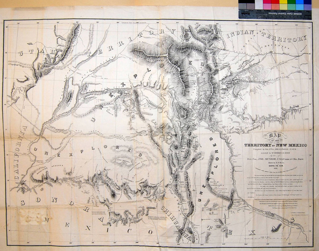
Political Map Of New Mexico Territory in the 1880s

Pathways Through the High Desert
For thousands of years, movement across the Grants–Milan region followed patterns shaped by the land, its landmarks, and the people who knew it best. These pathways connected communities, supported trade, and guided travelers long before modern roads existed. The themes below highlight the major systems of movement that shaped the high desert.


These pathways formed the foundation for the territorial roads, rail lines, and highways that would later shape the modern Grants–Milan region.
Spanish Movement Across the High Desert
(ca. 1600s–Early 1800s)
When Spanish travelers entered the region in the 1600s, they followed the same ancient paths that Puebloan communities had been navigating for thousands of years. These routes formed the earliest colonial travel corridors across the high desert and shaped how newcomers understood the land.
Indigenous Knowledge Guiding Newcomers
Spanish expeditions relied heavily on Indigenous guides and long‑established Puebloan trails. These routes threaded through the lava flows of El Malpaís, skirted the foothills of Mount Taylor (Tsoodzil), and connected mission communities such as Acoma and Laguna.
Without this deep local knowledge, movement across the region’s canyons, mesas, and volcanic terrain would have been nearly impossible. For Pueblo communities, these pathways were not only practical routes but connections between cultural landscapes, seasonal cycles, and sacred places.
Caminos of the Colonial Era
As Spanish settlements expanded, informal footpaths evolved into caminos—travel routes linking missions, ranches, and early mining areas. These were not engineered roads but adapted Indigenous trails chosen for:
• access to water
• manageable grades
• visibility of major landmarks
• safe crossings around lava fields
The corridor between Acoma and Laguna became one of the most traveled routes in the region, used by missionaries, traders, and later Territorial officials.
These caminos formed the first European‑documented routes through the Grants & Milan region, connecting the Rio Grande corridor to western pueblos and outlying communities.
Movement Between Early Communities
By the 1700s, travel increased between nearby settlements such as San Mateo, San Rafael, and Cubero. These routes supported mission activity, seasonal travel, and early ranching.
Spanish cartographers—including Bernardo de Miera y Pacheco—recorded these corridors in early maps that blended Indigenous knowledge with colonial perspectives.
After 1821, these same caminos continued under Mexican governance, linking pueblos, ranches, and mining areas until the U.S. takeover in 1846.
The Transition Toward Territorial Roads
By the early 1800s, Spanish‑era caminos had become the foundation for later transportation systems. As New Mexico entered its U.S. Territorial period (1846–1912), these long‑used routes adapted to new forms of movement:
• stagecoach transport
• wagon roads
• mining routes
• early settlement corridors
Many modern highways in the Grants–Milan region still follow these same pathways, preserving centuries of movement across the high desert.
As the 1800s progressed, these established caminos directly influenced where Territorial officials placed new wagon roads, stage lines, and eventually rail lines.

Territorial Roads Across the High Desert
(1846–1912)
When the United States took control of New Mexico in 1846, the Grants–Milan region entered a new era of movement. The long‑established Indigenous, Spanish, and Mexican routes remained the backbone of travel, but they began to adapt to new forms of mobility: military patrols, freight wagons, stage lines, mining transport, and early settlement traffic. These corridors connected remote communities to emerging Territorial centers and laid the foundation for the transportation systems that would shape the late 1800s.


“Territorial roads did not erase earlier pathways — they built upon them.”
From the original Fort Wingate at Gallinas to the arrival of the railroad, each new system of movement followed the logic of the land and the knowledge of the people who traveled it first.
Wagons & Coaches Across the High Desert
(ca. 1600s–1800s)
Long before automobiles or highways, wagon roads and stagecoach routes shaped movement across the Grants–Milan basin. These corridors followed the same Indigenous and Spanish pathways that came before them — tracing ridgelines, following draws and flats, and linking scarce water sources across the high desert.
Wagon Roads Shaping the Region
As New Mexico developed as a U.S. territory, a network of informal wagon routes emerged. Neighboring villages, mail carriers, and community travelers relied on these paths to move between destinations.
These routes were not arbitrary — they followed terrain that had guided movement for thousands of years:
• following arroyos and ridges
• skirting steep mesas or flood zones
• navigating buttes, mesas, and river benches
• mapping paths where surface water was available
• aligning with earlier Indigenous and Spanish travel corridors
The result was a landscape of practical, well‑worn routes long before any roads were formally surveyed or paved.
Stagecoach Lines and Regional Travel
By the mid‑1800s, stage lines connected communities such as:
• Santa María
• Cubero
• San Rafael
• San Mateo
and the early homesteads that would become Grants.
Stagecoaches carried passengers, mail, and freight across the basin. These routes strengthened long‑established patterns of travel, linking settlements to military forts, territorial capitals, and regional trading centers.
Freight and Commerce on the Move
By the late 1800s, wagon routes from the Zuni Mountains brought timber, ore, and goods from western settlements into Milan and Grants. Supplies moved outward to homesteads, ranches, and mining camps.
These wagon and stagecoach corridors helped shape Grants as a regional hub of commerce. Many of these routes later influenced the alignments of early territorial roads — and eventually, the first highways.
Laying the Groundwork for Modern Roads
By the early 1900s, many wagon and coach routes were:
• graded
• widened
• or formally surveyed as territorial roads
These alignments became the basis for the National Old Trails Road, and later, the alignment of U.S. Route 66 through the Grants–Milan corridor.
Roads of the Territorial Era
The arrival of the Atlantic & Pacific Railroad in the 1880s reshaped the Grants basin long before automobiles or highways arrived. Steel rails brought new industries, new workers, and new patterns of movement — transforming the region from a landscape of wagon roads into a transportation corridor that would later support Route 66 and the modern communities of Grants and Milan.


Atchison, Topeka & Santa Fe Railways Depot "Grants"


Blueprint: Santa Fe Railway Depot Modification Proposal (July 10, 1945)
These paired drawings show AT&SF’s plan to convert the 1912 two‑story depot into a modern single‑story structure. The elevation and floor plan together illustrate the proposed redesign — including new eave brackets, a simplified roofline, and a reconfigured interior.
The remodel was never carried out; instead, the depot was demolished and replaced with a new building in the late 1940s.
The National Old Trails Road
(1900s–1920s)
In the early 1900s, the National Old Trails Road brought the first wave of automobile travel through the Grants & Milan region, following earlier wagon and territorial routes across the high desert.
A Coast‑to‑Coast Dream Takes Shape
The National Old Trails Road (NOTR) was one of America’s earliest transcontinental highways, stretching from Maryland to California. As automobiles became more common, national boosters, local communities, and early road associations worked together to create a continuous route across the country.
Following the Logic of Older Trails
When NOTR reached western New Mexico, its alignment followed the same terrain logic that had shaped movement for centuries. The road skirted the lava flows of El Malpais, traced the foothills of Mount Taylor, and connected long‑established communities such as Acoma, Laguna, Cubero, and San Rafael.
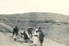
Grants & Milan on the Early Auto Map
By the 1910s, the Grants & Milan region became a recognized stop along the NOTR. Travelers passed through on rough dirt roads, stopping for fuel, water, repairs, and supplies. Early auto tourists often camped along the roadside, turning the region into a small but important waypoint on the growing national highway network.
A Precursor to Route 66
The success of the National Old Trails Road laid the groundwork for the creation of U.S. Route 66 in 1926. Much of Route 66’s original alignment in western New Mexico followed or paralleled the NOTR, making this early highway a direct ancestor of the road that would define Grants & Milan for decades.
Early Auto Travel Across the High Desert
In the early 1900s, automobile travelers crossed the Grants & Milan region on rough dirt roads shaped by earlier wagon and territorial routes. These early motorists helped place the region on the national map long before Route 66 was created.
Route 66 in the Grants–Milan Region
(1926 –1985)
How Trails, Settlements, Railroads, and Realignments Shaped the Mother Road
Route 66 officially entered the national highway system on November 11, 1926, but the corridor it followed through Grants and Milan had already been shaped by centuries of movement — from Indigenous trails and Spanish caminos to wagon roads, logging railroads, and the Atlantic & Pacific mainline. For nearly sixty years, Route 66 defined daily life, business, and identity in the region.
Early Trails, Los Alamitos, and the First Roads (Pre‑1872 to Early 1900s)
Long before Route 66 or the railroad, movement through the Grants–Milan region followed ancient Indigenous trails connecting the Zuni and Acoma Pueblos. In 1872, the agricultural settlement of Los Alamitos was founded along the Rio San José, becoming the earliest non‑Native community in the area. Early wagon roads naturally passed through Los Alamitos, forming the basis of the region’s first formal road network.
One of these early routes later became State Road 54, the predecessor to modern NM 53. This road approached Grants from San Rafael, passed the area of today’s KOA Campground, descended Zuni Canyon Road, entered Los Alamitos along San Jose Drive, continued onto El Morro Street, and finally joined what would become Santa Fe Avenue. This southern approach predates both the railroad and Route 66 and explains why the oldest residential and civic structures in Grants cluster around San Jose and El Morro.
Railroad Era and the Naming of Bluewater (1880s–1910s)
The arrival of the Atlantic & Pacific Railroad (1880–1883) transformed the region. Railroad sidings and water stops created new communities, including Bluewater Station, which had earlier appeared on Territorial and Spanish‑era maps as Blue Water and Agua Azul. The naming sequence reflects the region’s layered cultural history:
• Agua Azul — Spanish and early Territorial maps
• Blue Water — English Territorial usage
• Bluewater Station — A&P/ATSF railroad era
• Bluewater — modern form
These communities became the backbone of early automobile travel and later Route 66.
The 1926 Alignment of Route 66
When Route 66 was officially designated on November 11, 1926, the highway followed the railroad corridor through the Grants–Milan region. The original alignment passed through:
• Horace
• McCartys
• San Fidel
• Cubero
• Budville
• Bluewater Station
• Prewitt
• Thoreau
• Continental Divide
• Wingate
• Church Rock
• Gallup
This alignment closely paralleled the A&P/ATSF mainline and earlier Territorial roads.
Modernization: Paving, Widening, and Realignment (1930s–1960s)
Santa Fe Avenue, the local stretch of Route 66, was paved in 1938, marking the beginning of the modern highway era in Grants. Traffic increased rapidly, and by the late 1940s and 1950s, the road was widened to four lanes and equipped with median streetlights.
In 1956–1958, a major east‑spur realignment straightened Route 66 east of town, shifting traffic toward the corridor that would later become Interstate 40. This realignment replaced the original 1926 approach along what is now NM 117, still known locally as “the Old Road.”
During the late 1950s and early 1960s, Route 66 through Milan was widened again — including a short six‑lane section built to handle uranium‑era truck traffic and the heavy daily commuter flow to Planes Electric and Tri‑State Generation & Transmission. At the same time, the highway was widened westward toward Bluewater, Prewitt, and Thoreau, with improvements continuing through the 1960s as the corridor evolved toward interstate standards.
The 1957 Ghost Alignment and the South‑Side Civic Corridor
In 1957, the state began constructing a new straightened alignment of Route 66 on the south side of what is now Interstate 40. When federal engineers shifted the future interstate corridor slightly north, the 1957 roadway was abandoned mid‑project, leaving behind a paved but unused “ghost alignment.”
Instead of being removed, this abandoned segment became the foundation of a small civic and service district. On the west side, the National Guard Armory (now the Cibola County 911 Dispatch Center), the Dinosaur Museum (now the Cibola Senior Center), Lavaland RV Park, and the new Continental Divide Electric Cooperative headquarters developed along the corridor, leading locals to call the area “the Industrial Park.”
On the east side, the corridor later became home to the Grants Visitors Center, anchoring the entrance to town and continuing the pattern of civic use along this abandoned Route 66 alignment.
Interstate 40 and the End of Route 66 (1972–1985)
Interstate 40 opened through the Grants–Milan area in 1972, diverting nearly all through‑traffic away from Santa Fe Avenue and Highway 66. Although Route 66 remained federally designated until 1985, the practical end of the Mother Road here came the moment I‑40 opened. The old alignments, frontage roads, and abandoned segments now serve as reminders of the layered transportation history that shaped the region.
Regional Roads That Shaped the Corridor
Beyond Route 66 itself, the Grants–Milan region was shaped by a network of older roads that connected the towns to the surrounding mesas, mountains, and communities. These routes—some now state highways, others surviving as rural or forest roads—linked Grants to San Mateo, San Rafael, Bluewater Lake, McGaffey, the Zuni Mountains, Ambrosia Lake, Haystack, and the high desert toward Thoreau and Farmington. Long before Interstate 40, these corridors carried ranchers, miners, loggers, travelers, and families, forming the deeper transportation landscape that supported and surrounded the Mother Road.
Beyond Route 66 itself, the Grants–Milan region was shaped by a network of older roads that connected the towns to the surrounding mesas, mountains, and communities. These routes—some now state highways, others surviving as rural or forest roads—linked Grants to San Mateo, San Rafael, Bluewater Lake, McGaffey, the Zuni Mountains, Ambrosia Lake, Haystack, and the high desert toward Thoreau and Farmington. Long before Interstate 40, these corridors carried ranchers, miners, loggers, travelers, and families, forming the deeper transportation landscape that supported and surrounded the Mother Road.


Boom, Bust, and the Road to Preservation
The story of Grants–Milan is one of dramatic rises, sudden changes, and enduring resilience. As Route 66 brought travelers through the valley, the uranium boom transformed the region into one of the fastest‑growing communities in the Southwest. When both eras faded, the towns faced economic decline and shifting identities. Yet the landmarks, roads, and memories of these periods continue to shape the community today, inspiring new preservation efforts and a renewed appreciation for the region’s layered history.
The story of Grants–Milan is one of dramatic rises, sudden changes, and enduring resilience. As Route 66 brought travelers through the valley, the uranium boom transformed the region into one of the fastest‑growing communities in the Southwest. When both eras faded, the towns faced economic decline and shifting identities. Yet the landmarks, roads, and memories of these periods continue to shape the community today, inspiring new preservation efforts and a renewed appreciation for the region’s layered history.


Credits & Sources
Historic Photographs & Postcards
• Grants Café (Postcard) Original postcard; photographer unknown. Regional Route 66 postcard collections.
• Hillcrest Center Construction Photograph by Carroll Gunderson. Courtesy of the Gunderson family collection / Center for Southwest Research, University of New Mexico.
• Wayside Motel Photographer unknown. Sourced from regional Route 66 photographic archives.
• Charlie’s Radiator Service Photographer unknown. Contemporary photograph used with permission.
• Hotel Woodward (Postcards & Photographs) Mixed sources including early postcards and regional photographic collections; photographers unknown. Regional New Mexico historical collections.
Historic Maps & Cartographic Materials
• Mapa de la Provincia de Nuevo México (1778) Created by Bernardo de Miera y Pacheco, 1778. Source: Library of Congress, Geography & Map Division.
• Early Routes Across New Mexico (c. 1910–1920) Created by the U.S. Geological Survey. Source: New Mexico Digital Collections.
• AT&SF Railroad Depot Blueprint — Grants (c. 1910–1920) Created by the Atchison, Topeka & Santa Fe Railway. Source: Arizona Memory Project.
• AT&SF Railroad Depot Blueprint — Milan/Grants Area (c. 1910–1920) Created by the Atchison, Topeka & Santa Fe Railway. Source: Arizona Memory Project.
Research Materials & Archival Sources
• Grants Public Library (Mother Whiteside Memorial Library) — local history collections, regional archives, and community reference materials
• Cibola Historical Society — historical documents, photographs, oral histories, and regional research
• Grants MainStreet Project — downtown revitalization archives, historic building documentation, and Route 66 corridor materials
• Cibola Arts Council — cultural programming archives, community arts history, and regional creative documentation
• Grants Chamber of Commerce — business history, tourism materials, and community development records
Forest & Land‑Management Sources
• Cibola National Forest — Mt. Taylor Ranger District — archival photographs, forest‑management records, early logging documentation, and regional land‑use materials
• New Mexico Forestry Division — state forestry records, wildfire history, land‑use documentation, and regional forest‑management materials
• U.S. Forest Service — Cibola National Forest & Grasslands — historical forest management records and early timber operations
• U.S. Forest Service — Zuni Mountains District — archival maps, photographs, and documentation of recreation and timber development
• U.S. Department of Agriculture (USDA) — forest and land‑use reports relevant to the Grants–Milan region
State, Federal & Digital Archives
• New Mexico Digital Collections — maps, photographs, territorial documents, and early transportation materials
• Center for Southwest Research (University of New Mexico) — regional archives, manuscripts, and photographic collections
• Library of Congress — Geography & Map Division — historic maps and cartographic materials
• Arizona Memory Project — AT&SF railroad blueprints and regional transportation documents
• U.S. Geological Survey (USGS) — early route mapping, topographic surveys, and geological documentation
• National Archives and Records Administration (NARA) — federal transportation, infrastructure, and land‑management records
Route 66 & Regional History Sources
• New Mexico Route 66 Association — statewide preservation, documentation, and historical research
• Grants/Cibola County Route 66 Preservation Partners — local Route 66 heritage, business history, and corridor documentation
• Route 66 Road Ahead Partnership — national preservation and historical resources
• Route 66 Historical Societies & Community Archives — documentation of historic businesses, alignments, and cultural heritage
• Regional New Mexico Historical Collections — mixed photographic and documentary materials
• Contemporary Photographs Provided with Permission