

Santa Fe Avenue / US 66
(1926 Alignment)
Santa Fe Avenue carried the very first Route 66 alignment through Grants when the highway was designated in 1926.
This early corridor followed the town’s original street grid, passing small stores, garages, and homes long before the mid‑century boom. The 1926 alignment shows what Grants looked like in its earliest highway era—before neon, before motels, and before the interstate reshaped the town.
The 1926 Route 66 Path Through Grants
The original Route 66 path through Grants
-
When Route 66 was created in 1926, it followed the most direct path through Grants: straight down Santa Fe Avenue, parallel to the railroad. This alignment:
-
Entered Grants from the east along Santa Fe Ave
-
Continued through the early downtown grid
-
Passed the railroad corridor and early commercial buildings
-
Exited west toward Milan before later realignments shifted traffic
-
This was the original Mother Road through the community, long before the 1937 realignment and the later 1950s–60s expansion.
These pathways formed the foundation for the territorial roads, rail lines, and highways that would later shape the modern Grants–Milan region.
Puebloan Footpaths
For thousands of years, Puebloan communities across the ancient Southwest established trails that linked their culturally diverse villages. Many of these routes followed the natural contours of the land — skirting the lava flows of El Malpais, climbing the gentle slopes near Mount Taylor (Tsoodził), and tracing the edges of the Zuni Mountains. These paths connected homes, fields, gathering places, and water sources such as the Rio San José, forming a network of movement shaped by generations who knew the land intimately.
These footpaths endured through the Spanish conquest, the Mexican period, and into the modern era. European colonists almost certainly followed these same routes when establishing settlements and travel corridors. The trails Puebloan people forged across their homeland became the foundation for later transportation networks, and the traces left behind by generations help illuminate the region’s deep history.

Trade and Exchange Networks
The Grants & Milan region sat at the crossroads of a vast Indigenous trade world. Puebloan communities exchanged turquoise, pottery, salt, cotton, shells, and woven goods along routes that passed landmarks such as Acoma Pueblo, Laguna Pueblo, and the San Rafael Valley. These pathways linked the high desert to distant regions — reaching into what is now Mexico, the Plains, and the Great Basin.
Travelers often navigated by prominent features like Mount Taylor, which served as a constant visual guide across the landscape.
These exchanges were not only economic — they strengthened social relationships, ceremonial obligations, and diplomatic ties between communities. Over centuries, these well‑traveled routes became some of the most reliable corridors across the high desert. Later cultures, including Spanish and American travelers, adopted many of these same pathways because they represented the most efficient ways to move through the terrain.

Sacred Geography
The landscape surrounding Grants, Milan, and San Rafael is dense with spiritually significant places.
Mount Taylor (Tsoodził) rises above the region as a sacred mountain for multiple Indigenous nations.
The El Malpais lava fields, with their caves, flows, and ancient fissures, hold ceremonial meaning and appear in oral histories.
Trails often followed ridgelines near the Zuni Mountains, passed springs and seeps in the San Rafael Valley, and connected communities to sacred mesas such as Acoma and Laguna.
For many Indigenous peoples, these routes were more than simple paths — they marked the sacred geography of the land. They connected places of ritual importance and served as conduits for pilgrimage, prayer, and ceremony.
Even today, many Indigenous communities maintain these ancestral pathways, preserving their cultural and spiritual significance. The sacred geography of the region continues to inspire respect and reverence, reminding travelers that the land itself holds memory.

Spanish and Early Colonial Roads
When Spanish explorers and settlers arrived in the region in the 1600s, they relied heavily on Indigenous routes to navigate unfamiliar terrain. Many colonial caminos followed the same alignments that skirted the El Malpais lava fields, passed through the San Rafael Valley, and connected mission communities near Acoma and Laguna. These roads were shaped by the same logic that guided the original footpaths: access to water, manageable terrain, and visibility of major landmarks like Mount Taylor.
By the 1800s, as the region transitioned into U.S. territorial control, those ancient trails guided the placement of wagon roads, military routes, and eventually the alignments chosen for the first railway and automobile roads. Every major transportation corridor that would later define Grants & Milan traces its origins to these earliest Indigenous pathways.

Spanish Movement Across the High Desert
(ca. 1600s–Early 1800s)
When Spanish travelers entered the region in the 1600s, they followed the same ancient paths that Puebloan communities had been navigating for thousands of years. These routes formed the earliest colonial travel corridors across the high desert and shaped how newcomers understood the land.
Indigenous Knowledge Guiding Newcomers
Spanish expeditions relied heavily on Indigenous guides and long‑established Puebloan trails. These routes threaded through the lava flows of El Malpaís, skirted the foothills of Mount Taylor (Tsoodzil), and connected mission communities such as Acoma and Laguna.
Without this deep local knowledge, movement across the region’s canyons, mesas, and volcanic terrain would have been nearly impossible. For Pueblo communities, these pathways were not only practical routes but connections between cultural landscapes, seasonal cycles, and sacred places.
Caminos of the Colonial Era
As Spanish settlements expanded, informal footpaths evolved into caminos—travel routes linking missions, ranches, and early mining areas. These were not engineered roads but adapted Indigenous trails chosen for:
• access to water
• manageable grades
• visibility of major landmarks
• safe crossings around lava fields
The corridor between Acoma and Laguna became one of the most traveled routes in the region, used by missionaries, traders, and later Territorial officials.
These caminos formed the first European‑documented routes through the Grants & Milan region, connecting the Rio Grande corridor to western pueblos and outlying communities.
Movement Between Early Communities
By the 1700s, travel increased between nearby settlements such as San Mateo, San Rafael, and Cubero. These routes supported mission activity, seasonal travel, and early ranching.
Spanish cartographers—including Bernardo de Miera y Pacheco—recorded these corridors in early maps that blended Indigenous knowledge with colonial perspectives.
After 1821, these same caminos continued under Mexican governance, linking pueblos, ranches, and mining areas until the U.S. takeover in 1846.
The Transition Toward Territorial Roads
By the early 1800s, Spanish‑era caminos had become the foundation for later transportation systems. As New Mexico entered its U.S. Territorial period (1846–1912), these long‑used routes adapted to new forms of movement:
• stagecoach transport
• wagon roads
• mining routes
• early settlement corridors
Many modern highways in the Grants–Milan region still follow these same pathways, preserving centuries of movement across the high desert.
As the 1800s progressed, these established caminos directly influenced where Territorial officials placed new wagon roads, stage lines, and eventually rail lines.

Territorial Roads Across the High Desert
(1846–1912)
When the United States took control of New Mexico in 1846, the Grants–Milan region entered a new era of movement. The long‑established Indigenous, Spanish, and Mexican routes remained the backbone of travel, but they began to adapt to new forms of mobility: military patrols, freight wagons, stage lines, mining transport, and early settlement traffic. These corridors connected remote communities to emerging Territorial centers and laid the foundation for the transportation systems that would shape the late 1800s.
🌄 A Region in Transition
In the early Territorial period, the first major transportation networks were military and emigration roads stretching across the high desert. These routes followed the logic of the land—skirting lava flows, tracing ridges, and linking water sources—just as earlier Indigenous and Spanish caminos had done.
As new settlements emerged, these roads became essential corridors for communication, trade, and movement across the Grants–Milan region.

🐎 Wagon Roads, Military Routes, and the First Fort Wingate
One of the most significant developments of the era was the establishment of the original Fort Wingate at Gallinas (San Rafael) in 1862.
Located just east of present‑day Grants, the fort served as a military outpost, supply depot, and patrol base for regional routes.
The U.S. Army widened long‑used Indigenous and Spanish trails into wagon roads to support troop movement, supply trains, and early settlement. Many of these routes later influenced the placement of Territorial highways.

🚃 Stage Lines and Regional Travel
By the mid‑1800s, stage lines connected communities such as San Rafael, San Mateo, Cubero, and Laguna. These routes carried passengers, mail, and freight across the high desert, linking the region to Albuquerque, Santa Fe, and western New Mexico.
Stage stations—often located near springs or established settlements—served as rest stops, relay points, and hubs of local activity.
These lines strengthened economic ties and supported the growth of ranching, mining, and early commerce.

⛏️ Mining Roads and Local Industry
As mining expanded around Mount Taylor and the surrounding mesas, new roads were cut to reach timber stands, ore deposits, and work camps.
These rugged, seasonal routes played a crucial role in transporting ore, supplies, and workers between remote areas and regional markets.
Many of today’s backroads and forest routes trace their origins to these early mining corridors.

🛤️ The Coming of the Railroad
By the late 1800s, the arrival of the Atlantic & Pacific Railroad transformed movement across the high desert.
Rail lines followed many of the same pathways as earlier trails—avoiding lava flows, staying close to water, and threading through natural passes.
The railroad established new towns, including what would become Grants, and shifted the region’s economy toward timber, mining, and transportation.

🛣️ Toward the Age of Highways
Early automobile in front of the Yucca Hotel, Grants, New Mexico, ca. 1920s.
This postcard captures one of the earliest known views of motor travel in Grants. As automobiles began arriving in the early 20th century, hotels like the Yucca became essential stops for travelers crossing the high desert. These early cars marked the beginning of a new era of mobility that would eventually lead to the creation of Route 66.
Automobiles became common after World War I, and New Mexico’s first highway system emerged during the early 20th century. The arrival of the automobile transformed travel across the high desert, turning earlier wagon, mining, and stage routes into recognizable automobile corridors.
As New Mexico entered statehood in 1912, Territorial roads began to formalize into mapped automobile routes. These new alignments followed the same pathways that linked mining areas, ranching communities, and railroad service hubs. The transitions of the Territorial period guided the placement of early highways — including the future alignment of Route 66 across the Grants–Milan–San Rafael region.
As New Mexico approached statehood in 1912, Territorial roads began to formalize into early automobile routes.
These new roads often followed the same alignments as:
• wagon roads
• stage lines
• mining roads
• railroad service routes
The transitions of the Territorial period guided the placement of early highways — and eventually Route 66 — across the Grants–Milan–San Rafael region.

“Territorial roads did not erase earlier pathways — they built upon them.”
From the original Fort Wingate at Gallinas to the arrival of the railroad, each new system of movement followed the logic of the land and the knowledge of the people who traveled it first.
Wagons & Coaches Across the High Desert
(ca. 1600s–1800s)
Long before automobiles or highways, wagon roads and stagecoach routes shaped movement across the Grants–Milan basin. These corridors followed the same Indigenous and Spanish pathways that came before them — tracing ridgelines, following draws and flats, and linking scarce water sources across the high desert.
Wagon Roads Shaping the Region
As New Mexico developed as a U.S. territory, a network of informal wagon routes emerged. Neighboring villages, mail carriers, and community travelers relied on these paths to move between destinations.
These routes were not arbitrary — they followed terrain that had guided movement for thousands of years:
• following arroyos and ridges
• skirting steep mesas or flood zones
• navigating buttes, mesas, and river benches
• mapping paths where surface water was available
• aligning with earlier Indigenous and Spanish travel corridors
The result was a landscape of practical, well‑worn routes long before any roads were formally surveyed or paved.
Stagecoach Lines and Regional Travel
By the mid‑1800s, stage lines connected communities such as:
• Santa María
• Cubero
• San Rafael
• San Mateo
and the early homesteads that would become Grants.
Stagecoaches carried passengers, mail, and freight across the basin. These routes strengthened long‑established patterns of travel, linking settlements to military forts, territorial capitals, and regional trading centers.
Freight and Commerce on the Move
By the late 1800s, wagon routes from the Zuni Mountains brought timber, ore, and goods from western settlements into Milan and Grants. Supplies moved outward to homesteads, ranches, and mining camps.
These wagon and stagecoach corridors helped shape Grants as a regional hub of commerce. Many of these routes later influenced the alignments of early territorial roads — and eventually, the first highways.
Laying the Groundwork for Modern Roads
By the early 1900s, many wagon and coach routes were:
• graded
• widened
• or formally surveyed as territorial roads
These alignments became the basis for the National Old Trails Road, and later, the alignment of U.S. Route 66 through the Grants–Milan corridor.
Roads of the Territorial Era
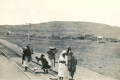
The arrival of the Atlantic & Pacific Railroad in the 1880s reshaped the Grants basin long before automobiles or highways arrived. Steel rails brought new industries, new workers, and new patterns of movement — transforming the region from a landscape of wagon roads into a transportation corridor that would later support Route 66 and the modern communities of Grants and Milan.
A Railroad Through the High Desert
When surveyors for the Atlantic & Pacific Railroad crossed the high desert in the early 1880s, they followed the same logic that had guided earlier travelers: ridgelines, passes, and reliable water sources. The rail line cut across the basin at a natural east–west corridor, linking Albuquerque to Gallup and the wider transcontinental network.
The construction of the line brought crews, camps, and new economic activity to the area — including the Grant brothers, whose railroad contract camp would soon give rise to the town of Grants.
Grants: A Railroad Community Emerges
Grants began as a railroad camp and quickly grew into a small but important stop along the line. The railroad enabled:
• shipment of timber from the Zuni Mountains
• transport of agricultural goods from new farms
• movement of supplies to mining districts
• steady passenger travel across the region.
With rail access, Grants became a hub for freight, commerce, and regional labor — decades before the highway era.

Logging Railroads and Mountain Industry
Short‑line and logging railroads extended into the Zuni Mountains, hauling:
• timber
• railroad ties
• mine timbers
• milled lumber
These spurs fed directly into the main line at Grants, strengthening the town’s role as a regional shipping point. The railroad tied the mountain economy to national markets and supported early settlement patterns across the basin.

A Region Transformed — But Milan Not Yet Founded
During the railroad era, Milan did not yet exist.
There was:
• no settlement
• no siding
• no depot
• no community identity
Milan would not be founded until the 1950s, when Salvador Milan established the community during the uranium boom and the height of Route 66 travel.
The railroad era shaped Grants — and created the transportation spine that Milan would later grow beside — but Milan itself is a mid‑20th‑century community, not a railroad town.
Setting the Stage for Early Highways
By the early 1900s, the railroad corridor influenced the placement of territorial roads and early automobile routes. Travelers often followed the rail line because it provided:
• predictable grades
• access to water
• nearby services
• a clear east–west path across the basin
These early roads eventually became part of the National Old Trails Road, the direct predecessor to U.S. Route 66.

Atchison, Topeka & Santa Fe Railways Depot "Grants"


Blueprint: Santa Fe Railway Depot Modification Proposal (July 10, 1945)
These paired drawings show AT&SF’s plan to convert the 1912 two‑story depot into a modern single‑story structure. The elevation and floor plan together illustrate the proposed redesign — including new eave brackets, a simplified roofline, and a reconfigured interior.
The remodel was never carried out; instead, the depot was demolished and replaced with a new building in the late 1940s.
The National Old Trails Road
(1900s–1920s)
In the early 1900s, the National Old Trails Road brought the first wave of automobile travel through the Grants & Milan region, following earlier wagon and territorial routes across the high desert.
A Coast‑to‑Coast Dream Takes Shape
The National Old Trails Road (NOTR) was one of America’s earliest transcontinental highways, stretching from Maryland to California. As automobiles became more common, national boosters, local communities, and early road associations worked together to create a continuous route across the country.
Following the Logic of Older Trails
When NOTR reached western New Mexico, its alignment followed the same terrain logic that had shaped movement for centuries. The road skirted the lava flows of El Malpais, traced the foothills of Mount Taylor, and connected long‑established communities such as Acoma, Laguna, Cubero, and San Rafael.
Grants & Milan on the Early Auto Map
By the 1910s, the Grants & Milan region became a recognized stop along the NOTR. Travelers passed through on rough dirt roads, stopping for fuel, water, repairs, and supplies. Early auto tourists often camped along the roadside, turning the region into a small but important waypoint on the growing national highway network.
A Precursor to Route 66
The success of the National Old Trails Road laid the groundwork for the creation of U.S. Route 66 in 1926. Much of Route 66’s original alignment in western New Mexico followed or paralleled the NOTR, making this early highway a direct ancestor of the road that would define Grants & Milan for decades.
Early Auto Travel Across the High Desert
In the early 1900s, automobile travelers crossed the Grants & Milan region on rough dirt roads shaped by earlier wagon and territorial routes. These early motorists helped place the region on the national map long before Route 66 was created.
Rough Roads and Early Motorists
Automobile travel across western New Mexico was challenging. Drivers navigated rutted dirt roads, sandy stretches, and steep grades, often carrying extra fuel, water, and spare tires. Despite the difficulties, early motorists brought new attention to the region.
Roadside Stops and Local Services
Communities along the National Old Trails Road offered essential services for travelers: water, repairs, food, and places to camp. These early roadside stops laid the groundwork for the motels, cafés, and service stations that would flourish during the Route 66 era.
Boosters and Road Associations
Local leaders and national road boosters promoted the NOTR as a reliable coast‑to‑coast route. Their efforts brought signage, basic improvements, and increased traffic through the Grants & Milan area, helping integrate the region into the growing national highway network.
A Pathway to Route 66
By the 1920s, the success of the National Old Trails Road influenced the alignment of U.S. Route 66. Many stretches of the NOTR were upgraded, straightened, or incorporated directly into the new federal highway, making it the true predecessor of the road that would define the region.
Route 66 in the Grants–Milan Region
(1926 –1985)
How Trails, Settlements, Railroads, and Realignments Shaped the Mother Road
Route 66 officially entered the national highway system on November 11, 1926, but the corridor it followed through Grants and Milan had already been shaped by centuries of movement — from Indigenous trails and Spanish caminos to wagon roads, logging railroads, and the Atlantic & Pacific mainline. For nearly sixty years, Route 66 defined daily life, business, and identity in the region.
How Trails, Settlements, Railroads, and Realignments Shaped the Mother Road
Route 66 officially entered the national highway system on November 11, 1926, but the corridor it followed through Grants and Milan had already been shaped by centuries of movement — from Indigenous trails and Spanish caminos to wagon roads, logging railroads, and the Atlantic & Pacific mainline. For nearly sixty years, Route 66 defined daily life, business, and identity in the region.
Early Trails, Los Alamitos, and the First Roads (Pre‑1872 to Early 1900s)
Long before Route 66 or the railroad, movement through the Grants–Milan region followed ancient Indigenous trails connecting the Zuni and Acoma Pueblos. In 1872, the agricultural settlement of Los Alamitos was founded along the Rio San José, becoming the earliest non‑Native community in the area. Early wagon roads naturally passed through Los Alamitos, forming the basis of the region’s first formal road network.
One of these early routes later became State Road 54, the predecessor to modern NM 53. This road approached Grants from San Rafael, passed the area of today’s KOA Campground, descended Zuni Canyon Road, entered Los Alamitos along San Jose Drive, continued onto El Morro Street, and finally joined what would become Santa Fe Avenue. This southern approach predates both the railroad and Route 66 and explains why the oldest residential and civic structures in Grants cluster around San Jose and El Morro.
Railroad Era and the Naming of Bluewater (1880s–1910s)
The arrival of the Atlantic & Pacific Railroad (1880–1883) transformed the region. Railroad sidings and water stops created new communities, including Bluewater Station, which had earlier appeared on Territorial and Spanish‑era maps as Blue Water and Agua Azul. The naming sequence reflects the region’s layered cultural history:
• Agua Azul — Spanish and early Territorial maps
• Blue Water — English Territorial usage
• Bluewater Station — A&P/ATSF railroad era
• Bluewater — modern form
These communities became the backbone of early automobile travel and later Route 66.
The 1926 Alignment of Route 66
When Route 66 was officially designated on November 11, 1926, the highway followed the railroad corridor through the Grants–Milan region. The original alignment passed through:
• Horace
• McCartys
• San Fidel
• Cubero
• Budville
• Bluewater Station
• Prewitt
• Thoreau
• Continental Divide
• Wingate
• Church Rock
• Gallup
This alignment closely paralleled the A&P/ATSF mainline and earlier Territorial roads.
Modernization: Paving, Widening, and Realignment (1930s–1960s)
Santa Fe Avenue, the local stretch of Route 66, was paved in 1938, marking the beginning of the modern highway era in Grants. Traffic increased rapidly, and by the late 1940s and 1950s, the road was widened to four lanes and equipped with median streetlights.
In 1956–1958, a major east‑spur realignment straightened Route 66 east of town, shifting traffic toward the corridor that would later become Interstate 40. This realignment replaced the original 1926 approach along what is now NM 117, still known locally as “the Old Road.”
During the late 1950s and early 1960s, Route 66 through Milan was widened again — including a short six‑lane section built to handle uranium‑era truck traffic and the heavy daily commuter flow to Planes Electric and Tri‑State Generation & Transmission. At the same time, the highway was widened westward toward Bluewater, Prewitt, and Thoreau, with improvements continuing through the 1960s as the corridor evolved toward interstate standards.
The 1957 Ghost Alignment and the South‑Side Civic Corridor
In 1957, the state began constructing a new straightened alignment of Route 66 on the south side of what is now Interstate 40. When federal engineers shifted the future interstate corridor slightly north, the 1957 roadway was abandoned mid‑project, leaving behind a paved but unused “ghost alignment.”
Instead of being removed, this abandoned segment became the foundation of a small civic and service district. On the west side, the National Guard Armory (now the Cibola County 911 Dispatch Center), the Dinosaur Museum (now the Cibola Senior Center), Lavaland RV Park, and the new Continental Divide Electric Cooperative headquarters developed along the corridor, leading locals to call the area “the Industrial Park.”
On the east side, the corridor later became home to the Grants Visitors Center, anchoring the entrance to town and continuing the pattern of civic use along this abandoned Route 66 alignment.
Interstate 40 and the End of Route 66 (1972–1985)
Interstate 40 opened through the Grants–Milan area in 1972, diverting nearly all through‑traffic away from Santa Fe Avenue and Highway 66. Although Route 66 remained federally designated until 1985, the practical end of the Mother Road here came the moment I‑40 opened. The old alignments, frontage roads, and abandoned segments now serve as reminders of the layered transportation history that shaped the region.
Regional Roads That Shaped the Corridor
Beyond Route 66 itself, the Grants–Milan region was shaped by a network of older roads that connected the towns to the surrounding mesas, mountains, and communities. These routes—some now state highways, others surviving as rural or forest roads—linked Grants to San Mateo, San Rafael, Bluewater Lake, McGaffey, the Zuni Mountains, Ambrosia Lake, Haystack, and the high desert toward Thoreau and Farmington. Long before Interstate 40, these corridors carried ranchers, miners, loggers, travelers, and families, forming the deeper transportation landscape that supported and surrounded the Mother Road.
Beyond Route 66 itself, the Grants–Milan region was shaped by a network of older roads that connected the towns to the surrounding mesas, mountains, and communities. These routes—some now state highways, others surviving as rural or forest roads—linked Grants to San Mateo, San Rafael, Bluewater Lake, McGaffey, the Zuni Mountains, Ambrosia Lake, Haystack, and the high desert toward Thoreau and Farmington. Long before Interstate 40, these corridors carried ranchers, miners, loggers, travelers, and families, forming the deeper transportation landscape that supported and surrounded the Mother Road.
San Mateo Road (NM 53)
The Old Road to San Rafael, San Mateo, and the Zuni Mountains
Long before it became NM 53, this corridor was known locally as San Mateo Road, the main route linking Grants to San Rafael, San Mateo, and the north side of Mount Taylor. It carried ranchers, loggers, miners, and travelers into the Zuni Mountains and the
Ambrosia Lake uranium district. During the uranium boom, San Mateo Road also served as a major industrial corridor, providing access to Kerr‑McGee, Homestake, Ambrosia Lake, and Haystack mining operations. F
arther west, the road connected to the White Horse and Chaco Slope region and long‑distance routes toward Thoreau, Crownpoint, and Farmington. Importantly, San Mateo Road linked to Route 66 in two places—entering Grants through Los Alamitos and reconnecting with the Mother Road again at Bluewater via NM 122—making it one of the region’s most significant historic corridors.

First Street and the North–South Connector (NM 547)
A State Road Hidden in Plain Sight
First Street is designated as NM 547, a quiet but essential state highway linking Route 66 to the neighborhoods north of the railroad tracks and to the Zuni Mountains via Lobo Canyon Road. As NM 547 climbs into the canyon, it reaches the Lobo Canyon Picnic Area—the spot locals call “the Square”—which also serves as a Continental Divide Trail access point. Farther up the road are facilities of the New Mexico Corrections Department and the former access route to the gypsum mine, whose material was once hauled to the
Grants plant for sheetrock production. Continuing higher into the mountains, NM 547 provides access to Mount Taylor, Lobo Canyon Campground, The Oaks, and Coal Mine Campground, making it one of the region’s most important historic and recreational corridors.
Golden Acres and the Early Road to Bluewater Lake
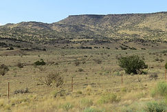
The First Access Route to the Lake and Canyon Country. Before the modern NM 612 entrance existed, the earliest road to Bluewater Lake branched from Route 66 and passed through Golden Acres, following older ranch and construction roads toward the canyon and the Bluewater Dam site.
This route predates the lake’s designation as a state park in 1954 and also connected to an older south‑side road leading toward Zuni. Golden Acres served as a small but important junction linking Route 66 to canyon communities, early recreation areas, and the high desert west of Grants.

Sawmill Road, McGaffey, and the Southern Zuni Mountains
A Historic Corridor Through Mount Sedgwick and Post Office Flats
West of Golden Acres, the old access route followed what is now Sawmill Road, passing near Mount Sedgwick, crossing Post Office Flats, and continuing toward McGaffey, a major logging and recreation hub.
This corridor provided the earliest southern access to the Bluewater Lake area and connected Route 66 to sawmills, CCC sites, Forest Service stations, and the high mesas of the Zuni Mountains.
Long before the interstate era, this road carried workers, families, and travelers into one of the region’s most important mountain landscapes.

El Malpaís and the South‑Side Landmarks
A Volcanic Landscape of Arches, Lava, and Deep History South of Grants lie El Malpaís, a vast volcanic landscape of lava flows, cinder cones, sandstone cliffs, and ancient travel routes.
Within this region stand some of the area’s most iconic landmarks. La Ventana Arch, one of New Mexico’s largest natural sandstone arches, rises dramatically above the valley floor. The Sandstone Bluffs Overlook offers sweeping views across the rugged lava fields, revealing the volcanic forces that shaped the region.
Farther west, the historic Ice Caves and Bandera Volcano preserve a rare natural ice chamber and one of the youngest volcanic features in the state. Accessed from the south‑side roads leading out of Grants, these sites form the heart of the El Malpaís landscape—a place where geology, history, and culture converge.

Boom, Bust, and the Road to Preservation
The story of Grants–Milan is one of dramatic rises, sudden changes, and enduring resilience. As Route 66 brought travelers through the valley, the uranium boom transformed the region into one of the fastest‑growing communities in the Southwest. When both eras faded, the towns faced economic decline and shifting identities. Yet the landmarks, roads, and memories of these periods continue to shape the community today, inspiring new preservation efforts and a renewed appreciation for the region’s layered history.
The story of Grants–Milan is one of dramatic rises, sudden changes, and enduring resilience. As Route 66 brought travelers through the valley, the uranium boom transformed the region into one of the fastest‑growing communities in the Southwest. When both eras faded, the towns faced economic decline and shifting identities. Yet the landmarks, roads, and memories of these periods continue to shape the community today, inspiring new preservation efforts and a renewed appreciation for the region’s layered history.
The Route 66 Era — A Town Comes Alive (1930s–1950s)
When Route 66 arrived in Grants, it transformed a small railroad community into a bustling roadside town. The highway brought travelers, truckers, families, and tourists — and with them came a wave of new businesses that lined Santa Fe Avenue.
🎬 Theaters & Entertainment
The LUX Theater became one of the earliest cultural anchors downtown, offering movies, newsreels, and a gathering place for locals. As the town grew, the West Theater opened, giving Grants a second major movie house and creating a lively entertainment district along Route 66.
🍽️ Cafés, Hotels & Early Commerce
The Hollywood Café / Hollywood Diner, Hotel Yucca & Café, and the Bernalillo Mercantile anchored the early business district.
During the aftermath of the 1958 Mike Todd plane crash, the Hollywood Diner became the temporary press room, where reporters and investigators gathered as the story unfolded — briefly placing Grants at the center of national news.
Nearby, the Grants Beacon Building (early 1920s) housed a rotating series of businesses and survives today as Serenade Music Co.
🔧 Service Stations & Motels
Charlie’s Radiator Service, a former Mobil station and now a registered historic landmark, kept travelers moving along the Mother Road.
Next door, the Los Alamitos Motel began life as a service station before converting to lodging as Route 66 traffic increased.
🍦 Early Franchises & Roadside Refreshments
On the 700 block of East Santa Fe, the early‑1950s Dairy Queen became one of the first national franchises in Grants. Local stories recall visits from Elvis Presley, who stopped there during his travels.
A second Dairy Queen opened in Milan on the 1300 block of Highway 66, serving the growing west‑side communities and travelers heading toward Bluewater and Gallup.

The Uranium Boom — A Town Explodes with Growth
(1950s–1960s)
A State Road Hidden in Plain SightThe discovery of uranium north of Grants triggered one of the most dramatic population booms in New Mexico history. Route 66 became the main artery feeding workers, families, and freight into the region.
🛍️ Hillcrest Center — Grants’ First Shopping Center (1958)
Built by Carroll Gunderson, Hillcrest Center opened in 1958 as Grants’ first true shopping center, introducing modern mid‑century retail design with multiple storefronts and large parking lots.
Before construction, a Gunderson Co. building on the site was moved to First Street, where it later became the original Checker Auto — a rare example of a commercial building being relocated rather than demolished.
🏭 Industrial Edge of Route 66
On the 300 East block, Croteau’s Trading Post stood across from the gypsum plant, serving workers, ranchers, and travelers entering Grants from the industrial corridor.
🏫 Community Infrastructure
At Anderman, High, and Stephens, the St. Teresa Community Center supported parish life, youth programs, and community events during the boom years.
🏨 Sands Motel — Elvis Stayed Here (Room 123)
The Sands Motel became one of Grants’ most recognizable mid‑century motels. Local accounts recall that Elvis Presley stayed at the Sands, and today Room 123 is dedicated to him — a living reminder of the town’s connection to one of America’s most iconic performers.

Decline & Transition — The Interstate Era
(1970s–1990s)
When I‑40 bypassed Route 66, traffic evaporated almost overnight. Businesses that had thrived for decades struggled or closed. Motels emptied. Cafés went dark. Theaters shuttered.
🍗 KFC on the 200 Block — Colonel Sanders’ Visit (Early 1970s)
In the early 1970s, Colonel Harland Sanders visited Grants while preparing to open the town’s first Kentucky Fried Chicken on the 200 block of East Santa Fe Avenue.
The restaurant was built on the site of the former Grants Mobil station and motel, reflecting the shift from classic Route 66 service businesses to modern fast‑food franchises.
🕰️ A Site That Tells the Story of Change
One location along Santa Fe Avenue captures the corridor’s evolution:
• Dairy King — early ice‑cream stand
• City of Grants Municipal Court — later civic use
• Route 66 Drive‑Thru — added much later as a nostalgic roadside feature
This single site mirrors the broader story of Route 66: growth, repurposing, decline, and revival.

Preservation & Renewal — Keeping the Mother Road Alive
(1990s–Present)
As nostalgia for Route 66 grew nationwide, Grants began reclaiming its roadside heritage. Historic buildings were stabilized, murals appeared, and community groups worked to preserve what remained of the Mother Road.
🏛️ Landmarks That Survived
• Charlie’s Radiator Service — protected landmark
• Grants Beacon Building — still in use as Serenade Music Co.
• Hillcrest Center — reminder of mid‑century prosperity
• Sands Motel — Room 123 dedicated to Elvis
• Route 66 Drive‑Thru — modern nod to the past.
🌄 The Road to Preservation
Today, Grants is preparing for the Route 66 Centennial, using its surviving buildings, stories, and community pride to reconnect with its identity as a historic highway town.

1930s–1940s:
Early Route 66
The First Travelers Across the High Desert
Before Route 66 became a major highway, this corridor already carried local agriculture and timber — including the well‑known carrot farms of the Grants basin and the long‑running logging operations from the Zuni Mountains. These industries relied on the early road network and continued shipping along Route 66 once it arrived.
When Route 66 reached the Grants–Milan region in the 1930s, it brought a steady flow of travelers across the high desert. Early motorists stopped for fuel, food, and repairs as the road stitched together small communities across New Mexico. Local businesses adapted quickly, offering essential services to drivers navigating the rugged terrain.
This era laid the foundation for the region’s identity as a welcoming stop along the Mother Road.
1940s–1950s:
Post‑War Boom
The Rise of Roadside Culture
After World War II, Route 66 saw a dramatic increase in traffic as families traveled west in search of opportunity. Motels, cafés, and service stations flourished along the corridor.
In Grants and Milan, neon signs, modern architecture, and new businesses transformed the once‑quiet stretch of highway into a lively commercial strip.
This period defined the classic Route 66 look that travelers still remember today.
1950s–1960s:
Uranium & Expansion
Industry, Workers, and a Changing Landscape
The discovery of uranium in the 1950s reshaped the Grants–Milan region. Workers, families, and new industries arrived rapidly, creating a booming local economy.
Route 66 became a vital artery for transporting goods, workers, and supplies.
Motels expanded, restaurants stayed open late, and the highway buzzed with activity. The road served as both a commercial lifeline and a cultural meeting point during this transformative era.
1970s–Present:
Decline & Preservation
From Bypass to Community Revival
When I‑40 bypassed Route 66 in the late 1970s, many businesses struggled or closed. Yet the spirit of the Mother Road endured. Local preservation groups, historians, and community members worked to protect surviving landmarks and celebrate the region’s Route 66 heritage.
Today, restored buildings, interpretive signage, and community projects keep the story alive for new generations of travelers.
Credits & Sources
Historic Photographs & Postcards
• Grants Café (Postcard) Original postcard; photographer unknown. Regional Route 66 postcard collections.
• Hillcrest Center Construction Photograph by Carroll Gunderson. Courtesy of the Gunderson family collection / Center for Southwest Research, University of New Mexico.
• Wayside Motel Photographer unknown. Sourced from regional Route 66 photographic archives.
• Charlie’s Radiator Service Photographer unknown. Contemporary photograph used with permission.
• Hotel Woodward (Postcards & Photographs) Mixed sources including early postcards and regional photographic collections; photographers unknown. Regional New Mexico historical collections.
Historic Maps & Cartographic Materials
• Mapa de la Provincia de Nuevo México (1778) Created by Bernardo de Miera y Pacheco, 1778. Source: Library of Congress, Geography & Map Division.
• Early Routes Across New Mexico (c. 1910–1920) Created by the U.S. Geological Survey. Source: New Mexico Digital Collections.
• AT&SF Railroad Depot Blueprint — Grants (c. 1910–1920) Created by the Atchison, Topeka & Santa Fe Railway. Source: Arizona Memory Project.
• AT&SF Railroad Depot Blueprint — Milan/Grants Area (c. 1910–1920) Created by the Atchison, Topeka & Santa Fe Railway. Source: Arizona Memory Project.
Research Materials & Archival Sources
• Grants Public Library (Mother Whiteside Memorial Library) — local history collections, regional archives, and community reference materials
• Cibola Historical Society — historical documents, photographs, oral histories, and regional research
• Grants MainStreet Project — downtown revitalization archives, historic building documentation, and Route 66 corridor materials
• Cibola Arts Council — cultural programming archives, community arts history, and regional creative documentation
• Grants Chamber of Commerce — business history, tourism materials, and community development records
Forest & Land‑Management Sources
• Cibola National Forest — Mt. Taylor Ranger District — archival photographs, forest‑management records, early logging documentation, and regional land‑use materials
• New Mexico Forestry Division — state forestry records, wildfire history, land‑use documentation, and regional forest‑management materials
• U.S. Forest Service — Cibola National Forest & Grasslands — historical forest management records and early timber operations
• U.S. Forest Service — Zuni Mountains District — archival maps, photographs, and documentation of recreation and timber development
• U.S. Department of Agriculture (USDA) — forest and land‑use reports relevant to the Grants–Milan region
State, Federal & Digital Archives
• New Mexico Digital Collections — maps, photographs, territorial documents, and early transportation materials
• Center for Southwest Research (University of New Mexico) — regional archives, manuscripts, and photographic collections
• Library of Congress — Geography & Map Division — historic maps and cartographic materials
• Arizona Memory Project — AT&SF railroad blueprints and regional transportation documents
• U.S. Geological Survey (USGS) — early route mapping, topographic surveys, and geological documentation
• National Archives and Records Administration (NARA) — federal transportation, infrastructure, and land‑management records
Route 66 & Regional History Sources
• New Mexico Route 66 Association — statewide preservation, documentation, and historical research
• Grants/Cibola County Route 66 Preservation Partners — local Route 66 heritage, business history, and corridor documentation
• Route 66 Road Ahead Partnership — national preservation and historical resources
• Route 66 Historical Societies & Community Archives — documentation of historic businesses, alignments, and cultural heritage
• Regional New Mexico Historical Collections — mixed photographic and documentary materials
• Contemporary Photographs Provided with Permission