
Downtown Grants
1100 W. Santa Fe Avenue &
Central Avenue (Railroad Ave)
Latham's General Store Parcel
Route Shields of Grants-Milan and Surrounding Area
The 1100 block of West Santa Fe Avenue represents one of the earliest developed areas of Grants, tracing its origins back to the original settlement of Los Alamitos, established in 1872 prior to the arrival of the railroad. The corridor later expanded during the railroad era following the arrival of the Atlantic & Pacific Railroad in 1881, developing along a long-established travel route.
Santa Fe Avenue serves as the town’s primary main street and historic Route 66 corridor, reflecting Grants’ transition from early settlement into a regional service center. Over time, this route evolved from early regional trails into the National Old Trails Road, eventually becoming the central commercial artery of the community.


1912-1926

1912-1926

1926-1948

1948-1961

1961-1971

1971-1985

1912-1927

1927-Present

1972-Present

1985-Present

1937-Present

1985-Present

1985-Present

1985-Present

1991-Present

1998-Present

1998-Present

2010-Present
Yucca Hotel & Cafe
1909 - 1966
Owner: George Ades
Manager: Charles Katzung (1911-1913)
The Yucca Hotel was developed beginning in 1909 through the partnership of George A. Ades and stonemason Joseph “Joe” Capelli, marking a major step in the transformation of the 1100 block of West Santa Fe Avenue into a structured commercial district. The project required the demolition of Latham’s Stockman’s Store, the original Latham location established on this site in 1882, which remained in operation here until 1910. The business later relocated within Grants before eventually returning to this original location in 1968.
Positioned directly across from the S. Bibo Brothers Mercantile (1105–1115 W), and within close proximity to the Atlantic & Pacific Railroad depot located behind the mercantile, the Yucca was strategically placed at the center of Grants’ early economic activity. This location allowed the hotel to serve railroad workers, traveling salesmen, and early automobile traffic moving through the corridor.
Working together, Ades and Capelli combined development and construction expertise to create a building that functioned as both a lodging establishment and a commercial hub. Their work reflects the shift from early settlement structures to more permanent business buildings, signaling the continued growth of Grants from its Los Alamitos origins into a functioning regional service center.
Building Spec List for the Yucca Hotel
● Designed by: ○ George Ades (owner/developer) ○ Joseph “Joe” Capelli (stonemason / craftsman / installer)
● Built by: ○ George Ades (owner/builder) ○ Joseph “Joe” Capelli (stonemason / construction and fabrication)
● Building / Sign Style: ○ Two‑story Spanish‑style exterior ○ Frame and stucco construction
● Built: ○ Construction began 1909 ○ Building completed 1910
● Opened: ○ 1910 (hotel begins operation) ○ 1911 — Charles Katzung becomes first confirmed manager
○ Earlier employment possible but undocumented
● Units / Rooms / Dimensions:
○ 13 upstairs guest rooms
○ 7 downstairs business rooms ○ 20 rooms total
● Amenities: ○ Pool: ○ None ○ Playground: ○ None
● Materials: ○ Wood framing ○ Stucco exterior ○ Early storefront façade elements
● Colors: ○ Period‑appropriate neutral stucco tones ○ Dark trim (per early photos)
● Mounting / Construction: ○ Traditional early‑20th‑century frame‑and‑stucco build
○ Street‑facing façade with early signage mount
Era Covered: ○ 1909–1912 (construction through early operation)
Operational Notes: ○ Lodging and dining operation ○ Served railroad workers, early auto travelers, and locals ○ Stable early operation under Katzung (from 1911)
● Identification Method: ○ Painted horizontal sign mounted at roof edge
● Period Context: ○ Territorial‑to‑statehood transition (NM statehood 1912) ○ Early automobile travel era
● Regional / Community Role: ○ Early anchor business in the Grants commercial core ○ Provided meals and lodging for local workforce
● Years in Service: ○ 56 years (1910–1966)
● Demolished / Fate:
○ Demolished 1966
Sign Spec List for the Yucca Hotel
● Designed by: ○ George Ades (owner/developer) ○ Joseph “Joe” Capelli (stonemason / craftsman / installer)
● Built by: ○ George Ades (owner/builder) ○ Joseph “Joe” Capelli (stonemason / construction and fabrication)
● Built: ○ Construction began 1909 ○ Installed by 1910 at hotel opening
● Installation: ○ In use by 1910
○ Still in use under Katzung by 1911
○ Earlier employment possible but undocumented
● Dimensions / Physical Characteristics:
○ Exact panel dimensions undocumented
○ Mounted above the roofline for visibility
○ Supported by metal frame and guy wires
○ Slightly offset from center
● Materials: ○ Painted wood sign face
○ Metal rear bracing
○ Metal support frame
○ Brackets, bolts, fasteners
○ Raw metal components
● Colors:
○ Case Color:
○ Forest Green
○ Lettering:
○ Cream White
○ Border:
○ Black
○ Metal components:
○ Raw/unpainted
Era Covered:
○ 1909–1912 (construction through early operation)
Mounting / Construction:
○ Lodging and dining operation ○ Served railroad workers, early auto travelers, and locals ○ Stable early operation under Katzung (from 1911)
● Identification Method: ○ Painted horizontal sign mounted at roof edge
● Period Context: ○ Territorial‑to‑statehood transition (NM statehood 1912) ○ Early automobile travel era
● Regional / Community Role: ○ Early anchor business in the Grants commercial core ○ Provided meals and lodging for local workforce
● Years in Service: ○ 56 years (1910–1966)
● Demolished / Fate:
○ Removed and lost during demolition 1966
Hotel Yucca & Cafe (Before and After)

COMING SOON
(No surviving pre‑Yucca block photo)

Earliest 1928–1929 horizontal sign photo
-
Same‑day bus photo
-
Horizontal sign installed
-
Pole removed
-
Lamp posts visible
-
Scaffold mount visible
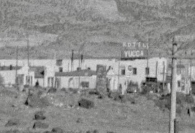
YUCCA
1910–1927 Yucca Hotel Rooftop Sign (Recreation)
Artifact: Recreation of the 1910–1927 Yucca Hotel rooftop sign based on later photographic evidence
Source: Cibola County Historical Museum — earliest 1928–1929 Yucca Hotel horizontal sign photograph (lamp posts visible, pole removed, scaffold mount)
Retrieved from: Cibola County Historical Museum photo archives; 1928–1929 streetscape reference materials
Caption: Rooftop sign recreation informed by the 1928–1929 horizontal sign photo showing lamp posts, scaffold mount, and the earliest surviving evidence of the hotel’s signage evolution
Ades & Capelli Development Network
Santa Fe Avenue Commercial Corridor
🔷 1100 BLOCK
📍 1100 W. Santa Fe Ave
Yucca Hotel (1909–1911 | Rebuild 1916)
-
Dev: George A. Ades
-
Build: Joseph Capelli
-
Lot: Block 11, Lot 1
-
Prev: Latham’s Store (1882–1910)
-
Features: 2-story, stucco, basalt foundation
-
Systems: well, water tower, steam boiler
Interior / Ground Floor:
-
Yucca Café (Ades)
-
Cocktail Lounge
-
Western Union
-
Blue Bell Telephone
-
Grants Barber Shop (Art Baca)
-
Western Auto
-
City Bakery (Masons)
-
Graham’s Jewelers
-
Grants Review (J.M. Chapman)
-
Brown’s Shoes & Repair
-
Grants State Bank (temporary office)
-
Ticket Stand / Depot Counter
Second Floor — Professional Offices
Occupants:
-
Physician (Doctor’s Office)
-
Dentist Office
📍 1112 W
Grants Theater (1910 | c.1915–1920 structure phase)
-
Dev: Ades
📍 1114 W
White Arrow Garage (1913)
-
Dev: Ades
-
Masonry: Capelli
📍 1116 W
Ades Commercial Building (c.1920)
-
Tenants: Laundromat (Garcias), Radio Repair
📍 1120 W
Ades Liquor Store (1940s)
📍 1100 Block (Rear)
Service / Utility Structures (c.1912–1915)
-
Dev: Ades
-
Build: Capelli
🔷 1000 BLOCK
📍 1018 W
Lux Theatre (1937)
-
Dev: Ades
-
Build: Capelli
-
Partner: Souris
📍 1020 W
Grants State Bank (1947)
-
Dev: Ades
📍 1022 W
Carridine’s Drug Store (1944)
-
Dev: Ades
-
Owner: W.E. Carridine
-
Build: Capelli
-
Structure: masonry + frame
-
Facade: stucco + brick
📍 1000 Block
Abe’s Liquor Store
-
Dev: Ades
🔷 900 BLOCK
📍 915 W
Ades Professional Building (c.1930s)
🔷 800 BLOCK
📍 800–810 W
Utility Annex / Rental Units (c.1930s)
🔷 700 BLOCK
📍 712 W
Variety Store Building (c.1928–1932)
🔷 600 BLOCK
📍 600–610 W. Santa Fe Ave
Structure: Commercial Building
Built: c.1925–1930
Developed By:
-
George A. Ades
Constructed By:
-
Joseph Capelli
Use:
-
Retail / commercial storefronts
🔷 500 BLOCK
📍 500 W. Santa Fe Ave
Structure: Chamber of Commerce Building
Built: 1940s
Developed By:
-
George A. Ades
📍 501 W. Santa Fe Ave
Structure: Modern Cleaners
Built: c.1935
Developed By:
-
George A. Ades
📍 508 W. Santa Fe Ave
Structure: Grants Hardware
Developed By:
-
George A. Ades
Constructed By:
-
Joseph Capelli
Operated By:
-
Walker Family
📍 512 W. Santa Fe Ave
Structure: Westerner Shop
Built: 1940s
Developed By:
-
George A. Ades
📍 515 W. Santa Fe Ave
Structure: Multi-Unit Retail Building
Built: 1940s
Developed By:
-
George A. Ades
🔷 400 BLOCK
📍 400 W. Santa Fe Ave
Structure: Grants Lumber & Sun Valley
Developed By:
-
George A. Ades
📍 408 W. Santa Fe Ave
Structure: Trade Shop Building
Built: 1940s
Developed By:
-
George A. Ades
Use:
-
Shoe repair
-
trade services
📍 421 W. Santa Fe Ave
Structure: Utility Warehouse
Built: 1940s
Developed By:
-
George A. Ades
🔷 300 BLOCK
📍 300–310 W. Santa Fe Ave
Structure: City Hall / Jail / Fire Department
Associated With:
-
George A. Ades
📍 312 W. Santa Fe Ave
Structure: Retail Units
Developed By:
-
George A. Ades
Use:
-
Tailor
-
Cobbler
📍 320 W. Santa Fe Ave
Structure: Post Office Lot
🔷 200 BLOCK
📍 200 W. Santa Fe Ave
Structure: Grants Garage / Chevrolet Garage
Built: c.1910 | Expanded 1918
Developed By:
-
George A. Ades
📍 204 W. Santa Fe Ave
Structure: Grants Mercantile
Built: c.1910
Developed By:
-
George A. Ades
📍 210 W. Santa Fe Ave
Structure: Orange Front Soda Shop
Built: c.1920
Developed By:
-
George A. Ades
Manager:
-
Claude Bowlin
📍 212–214 W. Santa Fe Ave
Structure: Grants Hall (formerly Valencia Hall)
Built: 1929
Developed By:
-
George A. Ades
Constructed By:
-
Joseph Capelli
📍 218 W. Santa Fe Ave
Structure: Red Ball Garage
Built: c.1930
Developed By:
-
George A. Ades
🔷 100 BLOCK
📍 100 Block W. Santa Fe Ave
Context:
-
Earliest commercial core of Grants
-
Developed following 1912 depot relocation to 101 W
-
Comprised of wood-frame structures prior to later masonry development
📍 c.1916 — Hotel Woodard
-
Wood-frame hotel
-
Railroad-era lodging
📍 c.1917 — Grants Drug
-
Pharmacy / retail
-
Served hotel corridor
📍 114 W. Santa Fe Ave — Whiteside Hotel & Café
Built: 1918
Owner / Operator:
-
Whiteside
Structure:
-
Wood-frame
Function:
-
Hotel + café
Construction Context:
-
Part of early builder/trade network preceding Ades–Capelli system
🔥 📍 1936 — THE GREAT FIRE OF 1936
Destroyed:
-
Woodard Hotel
-
Whiteside Hotel & Café
-
Grants Drug
-
Surrounding early commercial structures
🔍 IMPACT
-
Removed original downtown core
-
Transition to masonry + planned development
⚡💧 INFRASTRUCTURE (PLACE AT BOTTOM OR FULL WIDTH)
📍 1928 — POWER & WATER SYSTEMS
Power Provided By:
-
Carroll Gunderson
Water System Developed By:
-
George A. Ades
🔧 FUNCTION
-
Enabled modern commercial expansion
-
Supported theaters, hotels, utilities, and retail
🧠 SIGNIFICANCE
-
Marks transition to modern Grants infrastructure
-
Foundation for full corridor development
🪨 MALPAIS BASALT QUARRY
Owned By:
-
George A. Ades
-
Joseph Capelli
Purpose:
-
Structural material for corridor buildings
The 100 block of West Santa Fe Avenue represents the earliest phase of commercial development in Grants, established following the 1912 relocation of the Atchison, Topeka & Santa Fe Railway depot to 101 W. Santa Fe Avenue. Early businesses, including the Woodard Hotel, Grants Drug, and the Whiteside Hotel & Café at 114 W., served railroad workers, travelers, and the growing local population from wood-frame structures typical of the period. Construction within this block was part of the early development activity involving George A. Ades and stonemason Joseph “Joe” Capelli, whose work contributed to the formation of the town’s initial commercial core. This early district was largely destroyed in the Great Fire of 1936, marking a turning point in the corridor’s development. In the years surrounding this transition, infrastructure improvements played a critical role, as Carroll Gunderson established electrical service while George A. Ades controlled the water system, together enabling the expansion of more permanent, masonry-built commercial structures westward along Santa Fe Avenue.
Founders & Builders (1909-1910)
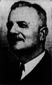
George A. Ades
1845 - 1922
🏗 George A. Ades George A. Ades, a Greek immigrant active in Grants by 1908, emerged as one of the most influential commercial and civic figures in the early development of the Grants–Milan region. Unlike many early settlers whose livelihoods were tied directly to the railroad, ranching, or mining industries, Ades established himself as a builder, merchant, and commercial strategist. Through property acquisition, construction, and infrastructure control, he positioned himself at the center of the town’s evolving business corridor along Santa Fe Avenue. His influence was not limited to a single structure or enterprise. Instead, Ades operated across multiple levels of development — land ownership, building construction, tenant placement, and utility control — forming what can best be understood as an interconnected commercial network spanning several blocks of the town. 🔷 Early Foundations & The Latham Connection Before the Yucca Hotel defined the corner of 1100 W. Santa Fe Avenue, the site was occupied by the Latham family’s Stockman’s Store, one of the earliest known commercial establishments in Grants. This establishes a direct and traceable lineage of development: Latham → Stockman’s Store → Parcel Transfer → Ades → Yucca Hotel The transfer of this property to Ades represents more than a simple land transaction. It reflects a shift in the structure of the local economy — from early, small-scale frontier commerce to more organized and strategically developed commercial space. Through this acquisition, Ades became directly tied to the earliest established business footprint on the block, anchoring his later developments in the town’s foundational history. 🔷 Construction of the Yucca Hotel (1909–1911) In 1909, Ades began construction of the Yucca Hotel, completing and opening it in 1910. At a time when much of Grants was still characterized by temporary wood-frame structures, the Yucca represented one of the first substantial and permanent commercial buildings in the town. By 1911, the first confirmed manager, Katzung, appears in the historical record — correcting a long-standing gap in documentation surrounding the hotel’s early operation. The Yucca was not simply a place of lodging. It functioned as a central hub of activity, combining hospitality, commerce, transportation services, and professional offices within a single structure. This type of multi-use design would become a defining characteristic of the corridor as it developed. 🔷 Effie Ades & The Yucca Café A critical yet often overlooked figure in the operation of the Yucca was Effie Ades, George’s wife, who managed the Yucca Café. Under her direction, the café became a central gathering place within the building and the broader community. The café served railroad workers, miners, travelers, and local residents, reinforcing the Yucca’s role as both a commercial and social center. Effie’s presence highlights the importance of family-operated enterprise in early Grants and places her at the core of the building’s daily life and identity. 🔷 The Yucca as a Multi-Use Structure The Yucca Hotel exemplified a fully integrated commercial building. Its ground floor housed a range of businesses and services, including retail shops, communication offices, and transportation functions such as ticketing and baggage handling. Above, the second floor contained professional offices, including a physician and dentist. This vertical integration of services reflects a practical and efficient use of space, allowing a single building to meet multiple needs within the growing town. It also demonstrates how early commercial structures in Grants were designed not just for occupancy, but for functionality within a larger system. 🔷 White Arrow Garage (1913) In 1913, Ades expanded his influence into the emerging automobile economy with the construction of the White Arrow Garage. As one of the earliest automobile service facilities in the region, it marked a clear transition from wagon-based transportation to motor vehicle use. This development demonstrates Ades’s ability to recognize and respond to technological and economic shifts. By investing in infrastructure that supported automobiles, he positioned his properties and businesses to remain relevant as transportation patterns changed. 🔷 Infrastructure & Civic Leadership Ades’s role in Grants extended beyond buildings into essential infrastructure. By 1928, he controlled the water system that supplied many of his properties and other buildings along Santa Fe Avenue. At the same time, Carroll Gunderson established electrical service within the town. Together, these privately controlled systems provided the foundation for modern commercial operations. Reliable water and electrical service made it possible to support theaters, hotels, retail businesses, and professional services at a scale that had not previously been possible. In addition to his commercial and infrastructural influence, Ades served as mayor, participating directly in the town’s early civic organization and development. 🔷 The Ades Commercial Network (1000–1100 W. Santa Fe) Ades’s developments along Santa Fe Avenue formed an interconnected network rather than a series of independent buildings. Concentrated primarily between the 1000 and 1100 blocks, this network included: Yucca Hotel (1909–1944) White Arrow Garage (1913) Grants Theater Lux Theatre (opened 1937) Carridine’s Drug Store Grants State Bank These properties functioned collectively as a commercial ecosystem, supporting one another through proximity, shared infrastructure, and overlapping clientele. This pattern of development represents one of the earliest examples of coordinated, multi-business planning in Grants. 🔷 Sale of the Yucca & Final Years In 1944, Ades sold the Yucca Hotel to Paul Drake, marking the end of his direct involvement with the building that had defined much of his early work. Two years later, on May 1, 1946, George A. Ades passed away. By the time of his death, the commercial corridor he helped establish had become a central feature of Grants, influencing both its economic activity and physical layout. 🔷 Demolition of the Yucca (1966) The Yucca Hotel was demolished in 1966 during a period when redevelopment trends often favored modernization over preservation. The removal of the building erased a key architectural anchor of the corridor, though its historical significance remains central to understanding the development of the area. 🔷 Legacy George A. Ades stands as a foundational figure in the development of modern Grants. His influence extends across multiple areas: Architectural development Commercial planning and business placement Civic leadership Infrastructure control (water systems) Multi-block commercial expansion More importantly, his work illustrates how the town developed not through isolated efforts, but through a network of interconnected people, properties, and services. This biography restores that network — a layered history that connects individuals, buildings, and infrastructure into a single, continuous story. Early Foundations & The Latham Connection Before the Yucca Hotel existed, the corner lot at 1100 W. Santa Fe Avenue was home to the Latham family’s Stockman’s Store. This establishes a direct lineage: Latham → Stockman’s Store → Parcel Transfer → Ades → Yucca Hotel Ades’s acquisition of Latham property represents a transfer of early commercial power and ties him to the earliest documented business footprint on the block. Construction of the Yucca Hotel (1909–1911) Ades began construction of the Yucca Hotel in 1909, completing and opening it in 1910. This was one of the first substantial, permanent commercial structures in Grants. The first confirmed manager, Katzung, appears in records by 1911, correcting decades of missing or misattributed history. The Yucca was not just a hotel — it was the first major architectural statement in downtown Grants, signaling a shift from frontier commerce to structured urban development. Effie Ades & The Yucca Café A nearly forgotten but critical fact: Effie Ades, George’s wife, managed the Yucca Café. Her work made the hotel a social hub for locals, travelers, railroad workers, and miners. This places Effie at the heart of the Yucca’s daily life and community identity. White Arrow Garage (1913) In 1913, Ades built the White Arrow Garage, one of the earliest automobile‑era service centers in the region. This marks Grants’ transition from wagon‑era commerce to the motor age and establishes Ades as a forward‑thinking builder aligned with technological change. Infrastructure & Civic Leadership Ades played a role in the 1928 power connection, helping bring modern electrical infrastructure to Grants. He also served as mayor, guiding the town through a period of early municipal development. The Ades Commercial Ecosystem (1000–1100 W. Santa Fe) Ades’s influence extended across multiple properties and businesses, forming a corridor‑wide commercial ecosystem that included: White Arrow Garage (1913) Carridine’s Drug Store Grants State Bank Grants Theater Lux Theatre (opened 1937) Yucca Hotel (1909–1944) This interconnected block represents one of the earliest multi‑business commercial clusters in Grants — and Ades was at its center. Sale of the Yucca & Final Years Ades sold the Yucca Hotel to Paul Drake in 1944. He passed away on May 1, 1946, leaving behind a legacy that shaped the architectural, commercial, and civic identity of Grants. Demolition of the Yucca (1966) The Yucca Hotel was demolished in 1966, a casualty of mid‑century redevelopment trends that favored parking lots and low‑rise structures over historic preservation. Its loss erased the physical anchor of the block — but not the history. Legacy George A. Ades stands as a founder of the modern commercial identity of Grants, with influence spanning: architecture business development civic leadership infrastructure modernization multi‑block commercial lineage This biography restores the full, interconnected story — much of which was never documented, never taught, and nearly lost.

Joesph "Joe" Cappelli
1880 - 1973
🏗 Joseph “Joe” Capelli Joseph “Joe” Capelli was an Italian-born stonemason and contractor who played a direct and physical role in shaping early Grants during its first major period of development. Working in close association with George A. Ades, Capelli was responsible for constructing some of the town’s earliest permanent commercial structures, helping transform Grants from a railroad siding into an established and functioning town. Capelli lived only a few blocks from the downtown corridor, placing him within the same environment he was actively building. His work took place during a critical period of transition, when early wood-frame structures were being replaced or supplemented by more durable construction methods capable of supporting long-term commercial growth. 🔷 Early Role in Grants & Construction Work Capelli emerged as one of the primary craftsmen during the early development of Santa Fe Avenue. While many early structures in Grants were temporary and quickly built to meet immediate needs, Capelli’s work reflects a shift toward permanence and structural stability. As a stonemason, his role went beyond simple construction. He provided the technical knowledge required to build foundations, walls, and structural elements that could withstand both time and environmental conditions. This was especially important in a town that would later experience destructive events such as the Great Fire of 1936, which exposed the weaknesses of earlier wood-frame construction. 🔷 Construction of the Yucca Hotel (1909–1911) Capelli is most closely associated with the construction of the Yucca Hotel, built for George A. Ades between 1909 and 1911 on the former site of Latham’s Stockman’s Store. This project represents one of the earliest substantial commercial builds in Grants and marked a turning point in how buildings were constructed within the town. The Yucca required coordinated effort between land acquisition, planning, and construction. Ades acted as the developer and organizer, while Capelli executed the physical construction. The result was a multi-use commercial structure that combined lodging, retail, transportation services, and professional offices within a single building. This project set a precedent for future development along Santa Fe Avenue, both in terms of function and construction quality. 🔷 Expansion Along Santa Fe Avenue Following the Yucca Hotel, Capelli continued to work on additional structures as development expanded westward along Santa Fe Avenue. His work became a consistent feature across multiple properties, particularly those associated with Ades’s growing commercial footprint. Buildings constructed during this period reflect: a shift toward masonry-supported construction more durable and permanent design increased investment in long-term commercial use Through repeated collaboration, Capelli and Ades contributed to the formation of a connected commercial corridor, rather than isolated individual buildings. 🔷 Construction Methods & Materials A defining aspect of Capelli’s work was the use of locally sourced materials, particularly malpais basalt. This material was widely used for foundations and structural elements, providing increased durability and resistance compared to earlier construction methods. Capelli’s masonry work helped establish a recognizable structural standard in Grants. Even as architectural styles varied, the underlying construction methods reflected a consistent approach to building that emphasized longevity. 🔷 Role Within the Development Network Within the broader development of Santa Fe Avenue, Capelli functioned as the primary builder responsible for turning plans into physical reality. His work was directly tied to the expansion of Ades’s properties and the growth of the commercial corridor. Their working relationship can be understood as a structured system: George A. Ades → land acquisition, development, infrastructure control Joseph Capelli → construction, masonry, structural execution This partnership allowed for coordinated growth across multiple blocks, creating a network of buildings that supported one another through shared location, function, and infrastructure. 🔷 Connection to Early Development (100 Block) Capelli’s work is also connected to the earlier development phase of the 100 block, where initial wood-frame buildings such as the Woodard Hotel, Grants Drug, and Whiteside Hotel & Café were constructed. While these structures represented an earlier stage of development, they formed the foundation upon which later, more permanent construction would expand. The transition from these early buildings to later masonry-supported structures reflects the broader evolution of Grants from a temporary railroad settlement into a more stable and organized commercial town. 🔷 Legacy Joseph “Joe” Capelli’s legacy is embedded in the physical construction of early Grants. His work represents the transition from temporary to permanent building practices and helped define the structural foundation of the town’s commercial corridor. Through his continued collaboration with George A. Ades, Capelli contributed to the development of a multi-block commercial system that supported businesses, services, and daily life for decades. While many of these structures have since been altered or removed, the impact of his craftsmanship remains central to understanding how Grants developed. More importantly, Capelli’s role illustrates that the growth of Grants was not driven by a single figure, but by a network of individuals whose combined efforts shaped the town. His work forms a critical part of that network, linking construction, commerce, and infrastructure into a unified historical narrative.

1910
Grant — Uranium Capital of the World

Grants Cut and Mt. Taylor
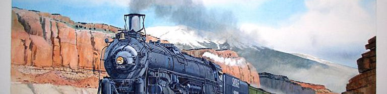
Locomotive 2926 heading west through
Grants Cut

Yucca Hotel & Cafe
1909 - 1966
YUCCA
Owner: George Ades
Manager: Charles Katzung
Phone # None
1910 — Opening of the Yucca Hotel
In 1910, the Yucca Hotel opened on the former Latham family Stockman’s Store parcel, one of the earliest commercial sites in Grants. When George A. Ades acquired the property in 1909, the removal of the original structure marked the beginning of a new phase of development on the west end of town. Constructed by stonemason Joseph “Joe” Capelli, the building represented one of the first substantial and permanent commercial structures in Grants.
Designed as a multi-use establishment, the Yucca Hotel provided lodging, dining, and essential services for both local residents and travelers moving along the railroad corridor. The Yucca Café, managed by Effie Ades, served as a central gathering place, offering meals to railroad workers, miners, and visitors entering the region.
In addition to its ground-floor commercial spaces, the hotel incorporated professional offices on the second floor, including a physician and dentist, reflecting the growing needs of an expanding community. This combination of services made the Yucca one of the earliest examples of a fully integrated commercial building in Grants.
With Charles Katzung documented as manager by 1911, the hotel quickly became a central hub of activity. Its opening signaled Grants’ transition from a small railroad siding into a developing commercial center, establishing the foundation for the business district that would expand along Santa Fe Avenue in the decades that followed.
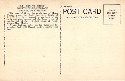
1910 — The Region Before the Yucca Era
A regional-era postcard representing the landscape surrounding Grants at the time the Yucca Hotel opened.

Ice Caves, South of Grants, New Mexico
c.1910

Title: Ice Caves, South of Grants, New Mexico
Postmarked: None
Postmark Route: None
Publisher: S.W. Post Card Co., Albuquerque, NM
Artist: None
Format: Printed postcard artwork
Type: RPPC (Real Photo Post Card)
Stamp: None
Box: “PLACE STAMP HERE” box — divided-back stamp box
Back Type: Divided back (U.S. standard after March 1, 1907)
Era: c.1910 (Yucca Hotel opening period, pre-Route 66)
Notes: Not specific to the Yucca Hotel; representative of regional imagery and travel destinations during the period
Context: Used to illustrate the environment and travel culture surrounding Grants at the time of the Yucca Hotel’s opening
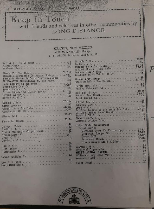
Artifact: Yucca Hotel directory listing and early business references (1927)
Source: Regional business directories and period listings documenting hotel services
Retrieved from: Surviving 1920s directory entries and local archival references
Caption: Early documentation showing the Yucca Hotel’s growth as a dependable lodging house during the pre–Route 66 boom years.
1910 Context — Early Grants Development
At the time of the Yucca Hotel’s opening, Grants remained a small but growing railroad community within New Mexico Territory. Commercial activity centered along Santa Fe Avenue, with development expanding westward from the original townsite.
The construction of the Yucca Hotel marked a shift toward permanent, multi-use buildings designed to support travelers, local residents, and emerging businesses. As one of the first substantial structures on the 1100 block, the Yucca established the foundation for continued commercial growth along the corridor.
While no confirmed photographs of the hotel exist from this period, regional postcards provide valuable context for the environment, travel patterns, and visual culture present at the time.
_svg.png)

1914
Grant — Uranium Capital of the World
Grants Cut and Mt. Taylor
Locomotive 2926 heading west through
Grants Cut
Yucca Hotel & Cafe
1909 - 1966
YUCCA
A regional-era postcard representing the landscape surrounding Grants at the time the Yucca Hotel opened.
Owner: George Ades
Manager: Charles Katzung
Phone # None
1914 — The Region Before the Yucca Hotel
In 1914, the west end of Grants remained lightly developed, with the Latham family’s Stockman’s Store parcel still serving as one of the few established commercial locations in the area. The surrounding landscape, reflected in regional postcards of the time, shows a community defined by open terrain, the railroad corridor, and scattered homesteads rather than formal lodging houses.
This year represents the final moment before the transition that would reshape the block. Within a few years, George A. Ades would acquire the Latham parcel and begin the process that led to the construction of the Yucca Hotel. The 1914 environment illustrates the setting into which the Yucca would soon emerge as one of Grants’ earliest permanent commercial anchors.
“Ice Caves, South of Grants, New Mexico.” Early postcard showing the regional landscape at the time the Yucca Hotel opened.
1914 — The Region Before the Yucca Era
“Mt. Taylor.” Fred Harvey postcard after a painting by Miss Mary Leeds Fulton, postmarked October 9, 1914.

1914 Fred Harvey Postcard — “Mt. Taylor”
After a painting by Miss Mary Leeds Fulton

Postmarked: October 9, 1914
Postmark Route: La Junta & Albuquerque R.P.O.
Publisher: Fred Harvey
Artist: Miss Mary Leeds Fulton
Format: Printed postcard artwork
Stamp: 1¢ Washington
Box: Generic “PLACE STAMP HERE” box — consistent with pre‑1920 postcard stock Back Type: Divided back (U.S. standard after March 1, 1907)
Era: 1914 (pre‑Yucca, pre‑Route‑66)
Notes: Represents the regional landscape east of Grants during the years immediately preceding the construction of the Yucca Hotel
Context: Authentic 1914 postcard documenting the environment and visual culture of the region before the west‑end business district began forming
Artifact: Fred Harvey postcard, La Junta & Albuquerque R.P.O
Source: Original 1914 mailed postcard
Retrieved from: Surviving 1920s directory entries and local archival references
Caption: Regional landscape imagery illustrating the environment surrounding Grants in the years immediately preceding the Yucca Hotel’s construction.
1915
Grant — Uranium Capital of the World
Grants Cut and Mt. Taylor
Locomotive 2926 heading west through
Grants Cut
Yucca Hotel & Cafe
1909 - 1966
YUCCA
Owner: George Ades
Manager: Charles Katzung
Phone # None
1915 — The Yucca Hotel in Its Early Years
By 1915, the Yucca Hotel had become a fully established lodging house on the former Latham Stockman’s Store parcel acquired by George A. Ades in 1909. The hotel’s café, operated by Effie Ades, served both local residents and railroad travelers, while the hotel itself was managed by Charles Katzung, the earliest confirmed manager in surviving records. The Yucca’s presence helped stabilize the west‑end business district, anchoring a block that had previously been little more than scattered storefronts and supply points.
Although no known 1915 photographs of the Yucca survive, the hotel was already functioning as a dependable stop for travelers and a recognizable commercial landmark in Grants. Its early years set the foundation for the district’s later growth, long before the arrival of Route 66 reshaped the town’s commercial identity.
A 1915 real photo postcard provides one of the earliest known images of the Yucca Hotel.
Early Yucca Hotel & Cafe Postcards
A collection of early postcards showing the Yucca Hotel and the developing west‑end business district before the arrival of Route 66.

Yucca Hotel real photo postcard, 1915.
One of the earliest known images of the Yucca Hotel, showing the building during its first years of operation before the 1916 fire and 1917 rebuild.

Postmarked: Unused (no cancellation) Publisher: Not printed on card Stamp
Box: Generic “PLACE STAMP HERE” box — consistent with pre‑1920 postcard stock Back Type: Divided back (U.S. standard after March 1, 1907)
Notes: The absence of a postmark and publisher imprint is typical of small‑batch hotel postcards sold locally in the 1910s.
Context: Produced more than a decade before Route 66 was designated in 1926, this postcard documents the Yucca Hotel in its earliest era and provides a rare pre‑highway view of Grants’ developing business district.
Artifact: Yucca Hotel real photo postcard (1915)
Source: Private postcard collections
Retrieved from: Surviving RPPC examples
Caption: Early image of the Yucca Hotel before the 1916 fire and 1917 reconstruction.
1916
Grant — Uranium Capital of the World
Grants Cut and Mt. Taylor
Locomotive 2926 heading west through
Grants Cut
Yucca Hotel & Cafe
(1917 Rebuild – 1920s Configuration)
Owner: George Ades
Manager:
Phone # None
1916 — Fire and Remodel
By 1916, the Yucca Hotel was operating as one of Grants’ earliest lodging houses, serving railroad workers, travelers, and local residents. Surviving real photo postcards from this period show the hotel in its original form, prior to the 1916 fire and the 1917 rebuild that reshaped its appearance. The fire did not destroy the structure, but it triggered the first major architectural changes, including the later addition of the balcony railing seen in all post‑1917.
No known photographs or postcards from 1916 have been identified.
Artifacts and Visual Record — 1916
A collection of early postcards showing the Yucca Hotel and the developing west‑end business district before the arrival of Route 66.

No surviving photographs or postcards are currently known that document the Yucca Hotel specifically in 1916. The fire and remodel are inferred from written references and from comparing later images of the building to its earliest known postcard views.
No surviving photographs or postcards are currently known that document the Yucca Hotel specifically in 1916. The fire and remodel are inferred from written references and from comparing later images of the building to its earliest known postcard views.
Artifact: No confirmed visual artifacts for 1916
Source: Written references; architectural comparison with pre‑1916 and post‑1917 images
Retrieved from: Local historical accounts; structural analysis
Caption: The 1916 fire and remodel are known only through text and later photographs.
1917
Grant — Uranium Capital of the World
Grants Cut and Mt. Taylor
Locomotive 2926 heading west through
Grants Cut
Yucca Hotel & Cafe
1909 - 1966
YUCCA
Owner: George A. Ades
Manager: Effie S. Ades (Cafe)
Manager:
Phone # None
1917 Visual Confirmation and Surrounding Context
The year 1917 marks the Yucca Hotel’s first confirmed visual documentation following the 1916 fire and the subsequent architectural rebuild. Surviving real‑photo postcards show the building in its earliest post‑fire configuration, including the squared façade, early balcony railing, rebuilt roofline, and updated second‑story arrangement. These images also confirm the surrounding commercial context, including the relocated Latham’s Stockman’s Store at 1016 W. Santa Fe—moved from its original Latham parcel and standing at this address until 1968—alongside other early structures that shaped the block’s development. Together, these elements establish the earliest verifiable physical environment surrounding the Yucca
Reopening, Operations, and Early Commercial Cluster
Following the 1916 fire, the Yucca Hotel completed its reconstruction and reopened to the public in 1917. The rebuild restored full lodging operations, reinstated the café under Effie Ades, and re‑established the building as a central stop for motorists and rail travelers. The year also aligns with broader block‑level activity, including the relocated Latham’s Stockman’s Store at 1016 (which would remain there until 1968 before returning to its original location), the 1916 construction of the Grants Theater at 1112, and the continued operation of earlier Ades‑era buildings such as the White Arrow Garage at 1114. These combined elements form the earliest confirmed commercial cluster surrounding the Yucca during its 1917 reopening.
1917 — Artifacts and Visual Record
A collection of early postcards showing the Yucca Hotel and the developing west‑end business district before the arrival of Route 66.
No surviving photographs or postcards are currently known that document the Yucca Hotel specifically in 1916. The fire and remodel are inferred from written references and from comparing later images of the building to its earliest known postcard views.
No surviving photographs or postcards are currently known that document the Yucca Hotel specifically in 1916. The fire and remodel are inferred from written references and from comparing later images of the building to its earliest known postcard views.
YUCCA
No surviving photographs or postcards are currently known that document the Yucca Hotel specifically in 1916. The fire and remodel are inferred from written references and from comparing later images of the building to its earliest known postcard views.
Artifact: No confirmed visual artifacts for 1916
Source: Written references; architectural comparison with pre‑1916 and post‑1917 images
Retrieved from: Local historical accounts; structural analysis
Caption: The 1916 fire and remodel are known only through text and later photographs.
1917 marks the earliest confirmed year with surviving visual evidence of the Yucca Hotel following the 1916 fire and architectural rebuild.
Remodel Architecture Box (1917 Rebuild)
Updated Building Specs (1917 Version)
Signage Evolution (1917 Entry)
Business Activity in the Yucca Block Area (1917)
-
squared façade
-
early balcony railing
-
rebuilt roofline
-
rebuilt window/door arrangement
-
rebuilt materials
-
rebuilt second‑story configuration
-
squared façade
-
early balcony railing
-
rebuilt roofline
-
rebuilt window/door arrangement
-
rebuilt materials
-
rebuilt second‑story configuration
-
rebuilt stair access
-
footprint retained
-
two‑story hotel + café
-
squared façade
-
early balcony railing
-
adobe/brick fireproof core
-
no fireplaces; no chimneys
-
coal‑fired boiler in partial basement
-
radiator heat via risers
-
rebuilt roofline (1917 configuration)
-
rebuilt second‑story layout
-
front stair access
-
commercial ground floor + lodging upstairs
-
footprint retained
-
first confirmed rooftop sign
-
left‑edge placement
-
bracket style
-
color
-
material
-
matchbook listed as non‑architectural
Businesses in the Yucca (1917 Entry)
-
Café (Effie Ades)
-
Doctor’s Offices Upstairs
-
Ticket Booth
-
Business Rooms
-
Lobby / Front Desk
-
Hotel Rooms
-
Block 1100 — Santa Fe Ave (NOTR)
-
Yucca Hotel & Café — 1100 W. Santa Fe Ave — rebuilt 1917
-
Early Ades activity — active by 1908
-
Latham’s Stockman’s Store — 1016 W. Santa Fe Ave — relocated Latham building, remained here until 1968
-
Block 1110 — Santa Fe Ave (NOTR)
-
Grants Theater — 1112 W. Santa Fe Ave — built 1917
-
Block 1000 — Santa Fe Ave (NOTR)
-
White Arrow Garage — 1000 W. Santa Fe Ave — built 1913
1923
Grant — Uranium Capital of the World
Grants Cut and Mt. Taylor
Locomotive 2926 heading west through
Grants Cut
Yucca Hotel & Cafe
1909 - 1966
YUCCA
Owner: George Ades
Manager:
Phone # None
1915 — Early Years of the Yucca Hotel
By 1915, the Yucca Hotel was operating as one of Grants’ earliest lodging houses, serving railroad workers, travelers, and local residents. Surviving real photo postcards from this period show the hotel in its original form, prior to the 1916 fire and 1917 rebuild that reshaped its appearance.
A 1915 real photo postcard provides one of the earliest known images of the Yucca Hotel.
Early Yucca Hotel & Cafe Postcards
A collection of early postcards showing the Yucca Hotel and the developing west‑end business district before the arrival of Route 66.

Yucca Hotel real photo postcard, 1915.
One of the earliest known images of the Yucca Hotel, showing the building during its first years of operation before the 1916 fire and 1917 rebuild.
Postmarked: Unused (no cancellation) Publisher: Not printed on card Stamp
Box: Generic “PLACE STAMP HERE” box — consistent with pre‑1920 postcard stock Back Type: Divided back (U.S. standard after March 1, 1907)
Notes: The absence of a postmark and publisher imprint is typical of small‑batch hotel postcards sold locally in the 1910s.
Context: Produced more than a decade before Route 66 was designated in 1926, this postcard documents the Yucca Hotel in its earliest era and provides a rare pre‑highway view of Grants’ developing business district.
Artifact: Yucca Hotel real photo postcard (1915)
Source: Private postcard collections
Retrieved from: Surviving RPPC examples
Caption: Early image of the Yucca Hotel before the 1916 fire and 1917 reconstruction.

1925
Grant — Uranium Capital of the World
Grants Cut and Mt. Taylor
Locomotive 2926 heading west through
Grants Cut
Yucca Hotel & Cafe
1909 - 1966
YUCCA
Owner: George Ades
Manager:
Phone # None
1915 — Early Years of the Yucca Hotel
By 1915, the Yucca Hotel was operating as one of Grants’ earliest lodging houses, serving railroad workers, travelers, and local residents. Surviving real photo postcards from this period show the hotel in its original form, prior to the 1916 fire and 1917 rebuild that reshaped its appearance.
A 1915 real photo postcard provides one of the earliest known images of the Yucca Hotel.
Early Yucca Hotel & Cafe Postcards
A collection of early postcards showing the Yucca Hotel and the developing west‑end business district before the arrival of Route 66.
Yucca Hotel real photo postcard, 1915.
One of the earliest known images of the Yucca Hotel, showing the building during its first years of operation before the 1916 fire and 1917 rebuild.
Yucca Hotel real photo postcard, 1915.
One of the earliest known images of the Yucca Hotel, showing the building during its first years of operation before the 1916 fire and 1917 rebuild.
Artifact: Yucca Hotel real photo postcard (1915)
Source: Private postcard collections
Retrieved from: Surviving RPPC examples
Caption: Early image of the Yucca Hotel before the 1916 fire and 1917 reconstruction.
1927
Grant — Uranium Capital of the World

Grants Cut and Mt. Taylor
Locomotive 2926 heading west through
Grants Cut
Yucca Hotel & Cafe
1909 - 1966
YUCCA
Owner: George Ades
Manager:
Phone # 1
1915 — Early Years of the Yucca Hotel
By 1915, the Yucca Hotel was operating as one of Grants’ earliest lodging houses, serving railroad workers, travelers, and local residents. Surviving real photo postcards from this period show the hotel in its original form, prior to the 1916 fire and 1917 rebuild that reshaped its appearance.
A 1915 real photo postcard provides one of the earliest known images of the Yucca Hotel.
1927 - Yucca Hotel & Cafe Postcards
A collection of early postcards showing the Yucca Hotel and the developing west‑end business district before the arrival of Route 66.
Yucca Hotel real photo postcard, 1915.
One of the earliest known images of the Yucca Hotel, showing the building during its first years of operation before the 1916 fire and 1917 rebuild.

Postmarked: Unused (no cancellation) Publisher: Not printed on card Stamp
Box: Generic “PLACE STAMP HERE” box — consistent with pre‑1920 postcard stock Back Type: Divided back (U.S. standard after March 1, 1907)
Notes: The absence of a postmark and publisher imprint is typical of small‑batch hotel postcards sold locally in the 1910s.
Context: Produced more than a decade before Route 66 was designated in 1926, this postcard documents the Yucca Hotel in its earliest era and provides a rare pre‑highway view of Grants’ developing business district.
Artifact: Yucca Hotel real photo postcard (1915)
Source: Private postcard collections
Retrieved from: Surviving RPPC examples
Caption: Early image of the Yucca Hotel before the 1916 fire and 1917 reconstruction.

1929
Grant — Uranium Capital of the World
Grants Cut and Mt. Taylor
Locomotive 2926 heading west through
Grants Cut
Yucca Hotel & Cafe
1909 - 1966
YUCCA
Owner: George Ades
Manager:
Phone # None
1915 — Early Years of the Yucca Hotel
By 1915, the Yucca Hotel was operating as one of Grants’ earliest lodging houses, serving railroad workers, travelers, and local residents. Surviving real photo postcards from this period show the hotel in its original form, prior to the 1916 fire and 1917 rebuild that reshaped its appearance.
A 1915 real photo postcard provides one of the earliest known images of the Yucca Hotel.
Early Yucca Hotel & Cafe Postcards
A collection of early postcards showing the Yucca Hotel and the developing west‑end business district before the arrival of Route 66.
Yucca Hotel real photo postcard, 1915.
One of the earliest known images of the Yucca Hotel, showing the building during its first years of operation before the 1916 fire and 1917 rebuild.
Postmarked: Unused (no cancellation) Publisher: Not printed on card Stamp
Box: Generic “PLACE STAMP HERE” box — consistent with pre‑1920 postcard stock Back Type: Divided back (U.S. standard after March 1, 1907)
Notes: The absence of a postmark and publisher imprint is typical of small‑batch hotel postcards sold locally in the 1910s.
Context: Produced more than a decade before Route 66 was designated in 1926, this postcard documents the Yucca Hotel in its earliest era and provides a rare pre‑highway view of Grants’ developing business district.
Artifact: Yucca Hotel real photo postcard (1915)
Source: Private postcard collections
Retrieved from: Surviving RPPC examples
Caption: Early image of the Yucca Hotel before the 1916 fire and 1917 reconstruction.
1930
Grant — Uranium Capital of the World
Grants Cut and Mt. Taylor
Locomotive 2926 heading west through
Grants Cut
Yucca Hotel & Cafe
1909 - 1966
YUCCA
Owner: George Ades
Manager:
Phone # 20
1915 — Early Years of the Yucca Hotel
By 1915, the Yucca Hotel was operating as one of Grants’ earliest lodging houses, serving railroad workers, travelers, and local residents. Surviving real photo postcards from this period show the hotel in its original form, prior to the 1916 fire and 1917 rebuild that reshaped its appearance.
A 1915 real photo postcard provides one of the earliest known images of the Yucca Hotel.
Early Yucca Hotel & Cafe Postcards
A collection of early postcards showing the Yucca Hotel and the developing west‑end business district before the arrival of Route 66.
Yucca Hotel real photo postcard, 1915.
One of the earliest known images of the Yucca Hotel, showing the building during its first years of operation before the 1916 fire and 1917 rebuild.
Postmarked: Unused (no cancellation) Publisher: Not printed on card Stamp
Box: Generic “PLACE STAMP HERE” box — consistent with pre‑1920 postcard stock Back Type: Divided back (U.S. standard after March 1, 1907)
Notes: The absence of a postmark and publisher imprint is typical of small‑batch hotel postcards sold locally in the 1910s.
Context: Produced more than a decade before Route 66 was designated in 1926, this postcard documents the Yucca Hotel in its earliest era and provides a rare pre‑highway view of Grants’ developing business district.
Artifact: Yucca Hotel real photo postcard (1915)
Source: Private postcard collections
Retrieved from: Surviving RPPC examples
Caption: Early image of the Yucca Hotel before the 1916 fire and 1917 reconstruction.
1931
Grant — Uranium Capital of the World
Grants Cut and Mt. Taylor
Locomotive 2926 heading west through
Grants Cut
Yucca Hotel & Cafe
1909 - 1966
YUCCA
Owner: George Ades
Manager:
Phone # 20
1915 — Early Years of the Yucca Hotel
By 1915, the Yucca Hotel was operating as one of Grants’ earliest lodging houses, serving railroad workers, travelers, and local residents. Surviving real photo postcards from this period show the hotel in its original form, prior to the 1916 fire and 1917 rebuild that reshaped its appearance.
A 1915 real photo postcard provides one of the earliest known images of the Yucca Hotel.
1931 — Mountain State Tel. & Tel Co.,
White Page listing for the Yucca Hotel.
Grants, New Mexico
Source: Photographs courtesy of the Cibola County History Museum.

Yucca Hotel real photo postcard, 1915.
One of the earliest known images of the Yucca Hotel, showing the building during its first years of operation before the 1916 fire and 1917 rebuild.
Artifact: Yucca Hotel real photo postcard (1915)
Source: Private postcard collections
Retrieved from: Surviving RPPC examples
Caption: Early image of the Yucca Hotel before the 1916 fire and 1917 reconstruction.
1933
Grant — Uranium Capital of the World
Grants Cut and Mt. Taylor
Locomotive 2926 heading west through
Grants Cut
Yucca Hotel & Cafe
1909 - 1966
YUCCA
Owner: George Ades
Manager:
Phone # 1
1915 — Early Years of the Yucca Hotel
By 1915, the Yucca Hotel was operating as one of Grants’ earliest lodging houses, serving railroad workers, travelers, and local residents. Surviving real photo postcards from this period show the hotel in its original form, prior to the 1916 fire and 1917 rebuild that reshaped its appearance.
A 1915 real photo postcard provides one of the earliest known images of the Yucca Hotel.
Early Yucca Hotel & Cafe Postcards
A collection of early postcards showing the Yucca Hotel and the developing west‑end business district before the arrival of Route 66.
Yucca Hotel real photo postcard, 1915.
One of the earliest known images of the Yucca Hotel, showing the building during its first years of operation before the 1916 fire and 1917 rebuild.
Postmarked: Unused (no cancellation) Publisher: Not printed on card Stamp
Box: Generic “PLACE STAMP HERE” box — consistent with pre‑1920 postcard stock Back Type: Divided back (U.S. standard after March 1, 1907)
Notes: The absence of a postmark and publisher imprint is typical of small‑batch hotel postcards sold locally in the 1910s.
Context: Produced more than a decade before Route 66 was designated in 1926, this postcard documents the Yucca Hotel in its earliest era and provides a rare pre‑highway view of Grants’ developing business district.
Artifact: Yucca Hotel real photo postcard (1915)
Source: Private postcard collections
Retrieved from: Surviving RPPC examples
Caption: Early image of the Yucca Hotel before the 1916 fire and 1917 reconstruction.
1935
Grant — Uranium Capital of the World
Grants Cut and Mt. Taylor
Locomotive 2926 heading west through
Grants Cut
Yucca Hotel & Cafe
1909 - 1966
H O T E L
YUCCA
Owner: George Ades
Manager:
Phone # 5
1935 Traveler Feature: Honeymoon on Route 66
In November 1935, a young couple traveled west along Route 66 in their new Ford three‑window coupe, documenting their honeymoon with photographs and handwritten notes. Their journey carried them through Texas, New Mexico, and Arizona at a time when much of Route 66 was still unpaved and roadside towns were only beginning to adapt to the growing stream of motorists.
Their handwritten travel list records each stop along the way, including the entry: “Hotel Yucca – Grants, N.M. — Nov. 16th, 1935.” This confirms their stay at the Yucca Hotel and anchors the date of the accompanying photographs.
The images preserved from this trip show the couple’s car parked in front of the Yucca Hotel, the wife standing along Route 66 in Texas, the husband at the Commercial Hotel in Holbrook, and a rough, unpaved stretch of the highway near Holbrook. These photographs, shared by their grandson Dan McDougall, offer a rare personal glimpse into early Route 66 travel during the Depression era and provide one of the few firsthand visual accounts of a 1930s stay at the Yucca Hotel.
“A 1935 honeymoon trip along Route 66 — including a stop at the Yucca Hotel.”
1935 — Traveler Photographs & Itinerary
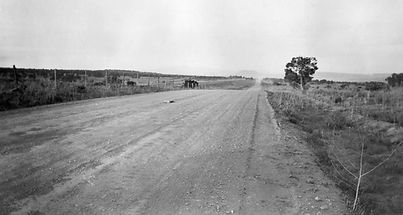
A view of a rough, unpaved stretch of the highway, capturing the conditions many motorists faced before the road was fully improved.
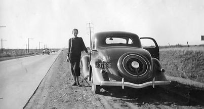
Their 1935 Ford coupe parked in front of the Yucca Hotel. A personal snapshot showing the hotel as travelers encountered it in the mid‑1930s.

A roadside portrait along the Texas stretch of Route 66, reflecting the open landscapes and informal stops typical of early highway travel.

A handwritten list documenting the couple’s day‑by‑day progress across the country, including the entry: “Hotel Yucca – Grants, N.M. — Nov. 16th, 1935.”
A companion image showing the husband and their car at another Route 66 hotel, illustrating the rhythm of overnight stops along the highway.
Source: Photographs courtesy of Dan McDougall; published by the Route 66 Postcards Facebook page.
1936
Grant — Uranium Capital of the World
Grants Cut and Mt. Taylor
Locomotive 2926 heading west through
Grants Cut
Yucca Hotel & Cafe
1909 - 1966
H O T E L
YUCCA
Owner: George Ades
Manager:
Phone # 1
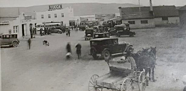
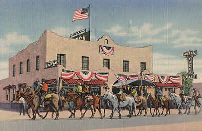
1936 — Yucca Hotel During the Rodeo Years
In 1936, the Yucca Hotel stood at the center of Grants’ Fourth of July rodeo festivities, with parade routes passing directly in front of the building. This period marks the hotel’s emergence as a recognizable Route 66 landmark, frequently appearing in photographs and commercial imagery tied to the town’s celebrations and growing highway traffic.
A 1936 parade photograph shows riders passing the Yucca Hotel during the annual rodeo celebration.
1936 — J. R. Willis Postcard
(Curt Teich 7A‑H2778)


Yucca Hotel real photo postcard, 1915.
One of the earliest known images of the Yucca Hotel, showing the building during its first years of operation before the 1916 fire and 1917 rebuild.
Yucca Hotel real photo postcard, 1936.
One of the earliest known images of the Yucca Hotel, showing the building during its first years of operation before the 1916 fire and 1917 rebuild.
Yucca Hotel real photo postcard, 1936.
One of the earliest known images of the Yucca Hotel, showing the building during its first years of operation before the 1916 fire and 1917 rebuild.
Artifact: Photograph of Fourth of July rodeo parade passing the Yucca Hotel (1936)
Source: Period photographs circulated in local collections and Route 66 historical archives
Retrieved from: Archival parade images showing downtown Grants during annual celebrations
Caption: Riders pass the Yucca Hotel during the 1936 Fourth of July rodeo, reflecting the hotel’s central role in community events.
1941
Grant — Uranium Capital of the World
Grants Cut and Mt. Taylor
Locomotive 2926 heading west through
Grants Cut
Yucca Hotel & Cafe
1909 - 1966
YUCCA
H O T E L

Owner: George Ades
Manager:
Phone # 1
1927 — Yucca Hotel Expands Services
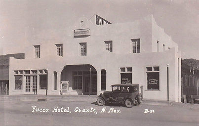
By 1927, the Yucca Hotel had become one of Grants’ most reliable lodging houses, offering meals, rooms, and traveler accommodations during the early years of Route 66. Local directory listings from this period show the hotel advertising steady service and dependable management, reflecting its growing role as a community anchor before the major highway boom of the 1930s.
A 1927 directory entry highlights the Yucca Hotel’s early reputation for consistent service and traveler accommodations.
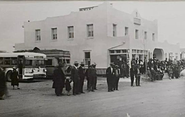
1941 — Fourth of July Parade
Grants, New Mexico
Source: Photographs courtesy of the Cibola County History Museum.

Yucca Hotel postcard, ca. 1927.
A late‑1920s view of the rebuilt Yucca Hotel, showing the barber shop and early automobile traffic during the first years of Route 66.

Yucca Hotel postcard, ca. 1927.
A late‑1920s view of the rebuilt Yucca Hotel, showing the barber shop and early automobile traffic during the first years of Route 66.
Artifact: Archival photographs of the 1941 Fourth of July Parade
Source: Cibola County History Museum
Retrieved from: Public post by the Cibola County History Museum on Facebook
Caption: Scenes from the 1941 Fourth of July Parade showing downtown Grants, including the Yucca Café, Cabot Drugs, and early Route 66 streetscape.
1943
Grant — Uranium Capital of the World
Grants Cut and Mt. Taylor
Locomotive 2926 heading west through
Grants Cut
Yucca Hotel & Cafe
1909 - 1966
YUCCA
H O T E L
Owner: George Ades
Manager:
Phone # 1
1927 — Yucca Hotel Expands Services
By 1927, the Yucca Hotel had become one of Grants’ most reliable lodging houses, offering meals, rooms, and traveler accommodations during the early years of Route 66. Local directory listings from this period show the hotel advertising steady service and dependable management, reflecting its growing role as a community anchor before the major highway boom of the 1930s.
1943 — Train View of the Yucca Hotel
Grants, New Mexico
Source: Photographs courtesy of the Cibola County History Museum.
Yucca Hotel postcard, ca. 1927.
A late‑1920s view of the rebuilt Yucca Hotel, showing the barber shop and early automobile traffic during the first years of Route 66.
Artifact: Archival photographs of the 1941 Fourth of July Parade
Source: Cibola County History Museum
Retrieved from: Public post by the Cibola County History Museum on Facebook
Caption: Scenes from the 1941 Fourth of July Parade showing downtown Grants, including the Yucca Café, Cabot Drugs, and early Route 66 streetscape.
A 1927 directory entry highlights the Yucca Hotel’s early reputation for consistent service and traveler accommodations.
1946
Grant — Uranium Capital of the World
Grants Cut and Mt. Taylor
Locomotive 2926 heading west through
Grants Cut
Yucca Hotel & Cafe
1909 - 1966
YUCCA
Owner: Paul Drakes
Manager: Mr. & Mrs Robert Hughs
Phone # 1
1927 — Yucca Hotel Expands Services
By 1927, the Yucca Hotel had become one of Grants’ most reliable lodging houses, offering meals, rooms, and traveler accommodations during the early years of Route 66. Local directory listings from this period show the hotel advertising steady service and dependable management, reflecting its growing role as a community anchor before the major highway boom of the 1930s.
A 1927 directory entry highlights the Yucca Hotel’s early reputation for consistent service and traveler accommodations.
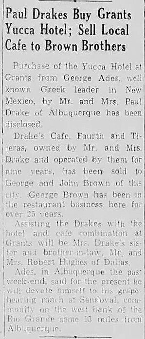
1946 — The Sale of the Yucca Hotel
Grants, New Mexico
Source: Photographs courtesy of the Cibola County History Museum.
Yucca Hotel postcard, ca. 1927.
A late‑1920s view of the rebuilt Yucca Hotel, showing the barber shop and early automobile traffic during the first years of Route 66.
Artifact: Archival photographs of the 1941 Fourth of July Parade
Source: Cibola County History Museum
Retrieved from: Public post by the Cibola County History Museum on Facebook
Caption: Scenes from the 1941 Fourth of July Parade showing downtown Grants, including the Yucca Café, Cabot Drugs, and early Route 66 streetscape.
1947
Grant — Uranium Capital of the World
Grants Cut and Mt. Taylor
Locomotive 2926 heading west through
Grants Cut
Yucca Hotel & Cafe
1909 - 1966
YUCCA
Owner: Paul Drake
Manager:
Phone # 1
1927 — Yucca Hotel Expands Services
By 1927, the Yucca Hotel had become one of Grants’ most reliable lodging houses, offering meals, rooms, and traveler accommodations during the early years of Route 66. Local directory listings from this period show the hotel advertising steady service and dependable management, reflecting its growing role as a community anchor before the major highway boom of the 1930s.
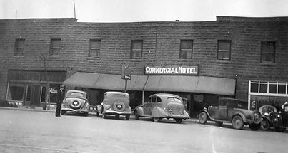
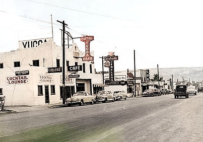
1946 — Street View of the
Yucca Hotel - Cafe, Cocktail Lounge &
Graham's Jewlers
Grants, New Mexico
Source: Photographs courtesy of the Colorized by Justin Zamora
Yucca Hotel postcard, ca. 1927.
A late‑1920s view of the rebuilt Yucca Hotel, showing the barber shop and early automobile traffic during the first years of Route 66.
Artifact: Archival photographs of the 1941 Fourth of July Parade
Source: Cibola County History Museum
Retrieved from: Public post by the Cibola County History Museum on Facebook
Caption: Scenes from the 1941 Fourth of July Parade showing downtown Grants, including the Yucca Café, Cabot Drugs, and early Route 66 streetscape.
A 1927 directory entry highlights the Yucca Hotel’s early reputation for consistent service and traveler accommodations.
1949
Grant — Uranium Capital of the World

Grants Cut and Mt. Taylor
Locomotive 2926 heading west through
Grants Cut
Yucca Hotel & Cafe
1910 - 1966
YUCCA
H O T E L
Owner: Paul Drake
Manager:
Phone # 1
1927 — Yucca Hotel Expands Services
By 1927, the Yucca Hotel had become one of Grants’ most reliable lodging houses, offering meals, rooms, and traveler accommodations during the early years of Route 66. Local directory listings from this period show the hotel advertising steady service and dependable management, reflecting its growing role as a community anchor before the major highway boom of the 1930s.
A 1927 directory entry highlights the Yucca Hotel’s early reputation for consistent service and traveler accommodations.
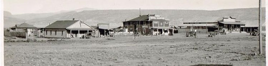
1949 — Street view of Route 66 with
the Yucca Hotel & Grahm's Jewler
Grants, New Mexico
Source: Photographs courtesy of the Cibola County History Museum.

Yucca Hotel postcard, ca. 1927.
A late‑1920s view of the rebuilt Yucca Hotel, showing the barber shop and early automobile traffic during the first years of Route 66.
Artifact: Archival photographs of the 1941 Fourth of July Parade
Source: Cibola County History Museum
Retrieved from: Public post by the Cibola County History Museum on Facebook
Caption: Scenes from the 1941 Fourth of July Parade showing downtown Grants, including the Yucca Café, Cabot Drugs, and early Route 66 streetscape.
1956
Grant — Uranium Capital of the World
Grants Cut and Mt. Taylor
Locomotive 2926 heading west through
Grants Cut
Yucca Hotel & Cafe
1909 - 1966
Owner: Paul Drake
Manager:
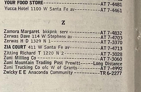
Phone # AT - 7-4461
1927 — Yucca Hotel Expands Services
By 1927, the Yucca Hotel had become one of Grants’ most reliable lodging houses, offering meals, rooms, and traveler accommodations during the early years of Route 66. Local directory listings from this period show the hotel advertising steady service and dependable management, reflecting its growing role as a community anchor before the major highway boom of the 1930s.
A 1927 directory entry highlights the Yucca Hotel’s early reputation for consistent service and traveler accommodations.
1956 — Mountain State Tel. & Tel Co.,
White Page listing for the Yucca Hotel.
Grants, New Mexico
Source: Photographs courtesy of the Cibola County History Museum.
Yucca Hotel postcard, ca. 1927.
A late‑1920s view of the rebuilt Yucca Hotel, showing the barber shop and early automobile traffic during the first years of Route 66.
Artifact: Archival photographs of the 1941 Fourth of July Parade
Source: Cibola County History Museum
Retrieved from: Public post by the Cibola County History Museum on Facebook
Caption: Scenes from the 1941 Fourth of July Parade showing downtown Grants, including the Yucca Café, Cabot Drugs, and early Route 66 streetscape.
1957
Grant — Uranium Capital of the World
Grants Cut and Mt. Taylor
Locomotive 2926 heading west through
Grants Cut
Yucca Hotel & Cafe
1909 - 1966
Owner: Paul Drake
Manager:
Phone # 1
1927 — Yucca Hotel Expands Services
By 1927, the Yucca Hotel had become one of Grants’ most reliable lodging houses, offering meals, rooms, and traveler accommodations during the early years of Route 66. Local directory listings from this period show the hotel advertising steady service and dependable management, reflecting its growing role as a community anchor before the major highway boom of the 1930s.
A 1927 directory entry highlights the Yucca Hotel’s early reputation for consistent service and traveler accommodations.
1957 — Street view of Route 66 and
the Yucca Hotel & Conley Motor Co.
Grants, New Mexico
Source: Photographs courtesy of the Cibola County History Museum.
Yucca Hotel postcard, ca. 1927.
A late‑1920s view of the rebuilt Yucca Hotel, showing the barber shop and early automobile traffic during the first years of Route 66.
Artifact: Archival photographs of the 1941 Fourth of July Parade
Source: Cibola County History Museum
Retrieved from: Public post by the Cibola County History Museum on Facebook
Caption: Scenes from the 1941 Fourth of July Parade showing downtown Grants, including the Yucca Café, Cabot Drugs, and early Route 66 streetscape.
1964
Grant — Uranium Capital of the World

Grants Cut and Mt. Taylor
Locomotive 2926 heading west through
Grants Cut
Yucca Hotel & Cafe
1909 - 1966
Owner: Paul Drake
Manager:
Phone # 1
1927 — Yucca Hotel Expands Services
By 1927, the Yucca Hotel had become one of Grants’ most reliable lodging houses, offering meals, rooms, and traveler accommodations during the early years of Route 66. Local directory listings from this period show the hotel advertising steady service and dependable management, reflecting its growing role as a community anchor before the major highway boom of the 1930s.
A 1927 directory entry highlights the Yucca Hotel’s early reputation for consistent service and traveler accommodations.
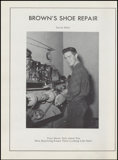
1964 — Yearbook sponsor page
the Yucca Hotel & Brown's Shoe Repair
Grants, New Mexico
Source: Photographs courtesy of the "Pirates Ahoy" Grants High School 1964 Annual
Yucca Hotel postcard, ca. 1927.
A late‑1920s view of the rebuilt Yucca Hotel, showing the barber shop and early automobile traffic during the first years of Route 66.
Artifact: Archival photographs of the 1941 Fourth of July Parade
Source: Cibola County History Museum
Retrieved from: Public post by the Cibola County History Museum on Facebook
Caption: Scenes from the 1941 Fourth of July Parade showing downtown Grants, including the Yucca Café, Cabot Drugs, and early Route 66 streetscape.
1966
Grant — Uranium Capital of the World
Grants Cut and Mt. Taylor
Locomotive 2926 heading west through
Grants Cut
Yucca Hotel & Cafe
1909 - 1966
Owner: George Ades
Manager:
Phone # 1
1927 — Yucca Hotel Expands Services
By 1927, the Yucca Hotel had become one of Grants’ most reliable lodging houses, offering meals, rooms, and traveler accommodations during the early years of Route 66. Local directory listings from this period show the hotel advertising steady service and dependable management, reflecting its growing role as a community anchor before the major highway boom of the 1930s.
A 1927 directory entry highlights the Yucca Hotel’s early reputation for consistent service and traveler accommodations.
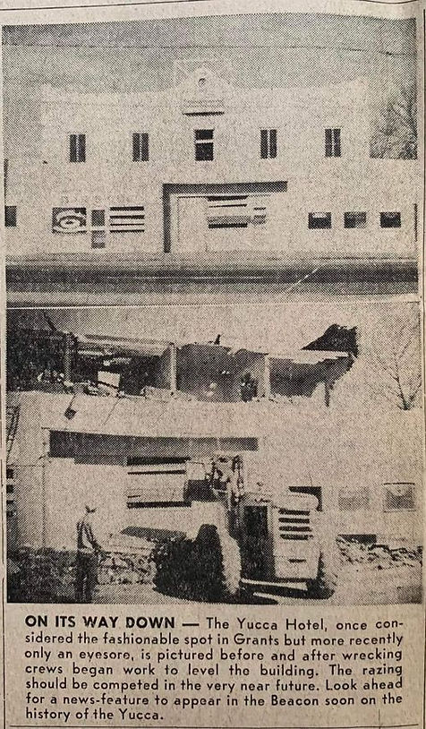
1966 — End of an Era
Demolition of The Yucca Hotel
Grants, New Mexico
Source: Photographs courtesy of the Grants Daily Beacon
November 16, 1966
Yucca Hotel postcard, ca. 1927.
A late‑1920s view of the rebuilt Yucca Hotel, showing the barber shop and early automobile traffic during the first years of Route 66.
Artifact: Archival photographs of the 1941 Fourth of July Parade
Source: Cibola County History Museum
Retrieved from: Public post by the Cibola County History Museum on Facebook
Caption: Scenes from the 1941 Fourth of July Parade showing downtown Grants, including the Yucca Café, Cabot Drugs, and early Route 66 streetscape.
1968
Grant — Uranium Capital of the World
Grants Cut and Mt. Taylor
Locomotive 2926 heading west through
Grants Cut
Latham's Stockman's Store
1968 - 1990s
Owner: George Ades
Manager:
Phone # 1
1927 — Yucca Hotel Expands Services
By 1927, the Yucca Hotel had become one of Grants’ most reliable lodging houses, offering meals, rooms, and traveler accommodations during the early years of Route 66. Local directory listings from this period show the hotel advertising steady service and dependable management, reflecting its growing role as a community anchor before the major highway boom of the 1930s.
A 1927 directory entry highlights the Yucca Hotel’s early reputation for consistent service and traveler accommodations.
1957 — Street view of Route 66 and
the Yucca Hotel & Conley Motor Co.
Grants, New Mexico
Source: Photographs courtesy of the Cibola County History Museum.
Yucca Hotel postcard, ca. 1927.
A late‑1920s view of the rebuilt Yucca Hotel, showing the barber shop and early automobile traffic during the first years of Route 66.
Artifact: Archival photographs of the 1941 Fourth of July Parade
Source: Cibola County History Museum
Retrieved from: Public post by the Cibola County History Museum on Facebook
Caption: Scenes from the 1941 Fourth of July Parade showing downtown Grants, including the Yucca Café, Cabot Drugs, and early Route 66 streetscape.

1975
Grant — Uranium Capital of the World

Grants Cut and Mt. Taylor
Locomotive 2926 heading west through
Grants Cut
Latham's Stockman's Store
1968 - 1990s
Owner: Bruce & Kelly Latham
Manager:
Phone: 284-4201
1927 — Yucca Hotel Expands Services
By 1927, the Yucca Hotel had become one of Grants’ most reliable lodging houses, offering meals, rooms, and traveler accommodations during the early years of Route 66. Local directory listings from this period show the hotel advertising steady service and dependable management, reflecting its growing role as a community anchor before the major highway boom of the 1930s.
A 1927 directory entry highlights the Yucca Hotel’s early reputation for consistent service and traveler accommodations.
1957 — Street view of Route 66 and
the Yucca Hotel & Conley Motor Co.
Grants, New Mexico
Source: Photographs courtesy of the Cibola County History Museum.

Yucca Hotel postcard, ca. 1927.
A late‑1920s view of the rebuilt Yucca Hotel, showing the barber shop and early automobile traffic during the first years of Route 66.
Artifact: Archival photographs of the 1941 Fourth of July Parade
Source: Cibola County History Museum
Retrieved from: Public post by the Cibola County History Museum on Facebook
Caption: Scenes from the 1941 Fourth of July Parade showing downtown Grants, including the Yucca Café, Cabot Drugs, and early Route 66 streetscape.
1976
Grant — Uranium Capital of the World
Grants Cut and Mt. Taylor
Locomotive 2926 heading west through
Grants Cut
Latham's Stockman's Store
1968 - 1990s
Owner: Bruce & Kelly Latham
Manager:
Phone: 284-4201
1927 — Yucca Hotel Expands Services
By 1927, the Yucca Hotel had become one of Grants’ most reliable lodging houses, offering meals, rooms, and traveler accommodations during the early years of Route 66. Local directory listings from this period show the hotel advertising steady service and dependable management, reflecting its growing role as a community anchor before the major highway boom of the 1930s.
A 1927 directory entry highlights the Yucca Hotel’s early reputation for consistent service and traveler accommodations.
1957 — Street view of Route 66 and
the Yucca Hotel & Conley Motor Co.
Grants, New Mexico
Source: Photographs courtesy of the Cibola County History Museum.

Artifact: Archival photographs of the 1941 Fourth of July Parade
Source: Cibola County History Museum
Retrieved from: Public post by the Cibola County History Museum on Facebook
Caption: Scenes from the 1941 Fourth of July Parade showing downtown Grants, including the Yucca Café, Cabot Drugs, and early Route 66 streetscape.
Yucca Hotel postcard, ca. 1927.
A late‑1920s view of the rebuilt Yucca Hotel, showing the barber shop and early automobile traffic during the first years of Route 66.
1978
Grant — Uranium Capital of the World
Grants Cut and Mt. Taylor
Locomotive 2926 heading west through
Grants Cut
Latham's Stockman's Store
1968 - 1990s
Owner: Bruce & Kelly Latham
Manager:
Phone: 287-4201
1927 — Yucca Hotel Expands Services
By 1927, the Yucca Hotel had become one of Grants’ most reliable lodging houses, offering meals, rooms, and traveler accommodations during the early years of Route 66. Local directory listings from this period show the hotel advertising steady service and dependable management, reflecting its growing role as a community anchor before the major highway boom of the 1930s.
A 1927 directory entry highlights the Yucca Hotel’s early reputation for consistent service and traveler accommodations.
1957 — Street view of Route 66 and
the Yucca Hotel & Conley Motor Co.
Grants, New Mexico
Source: Photographs courtesy of the Cibola County History Museum.
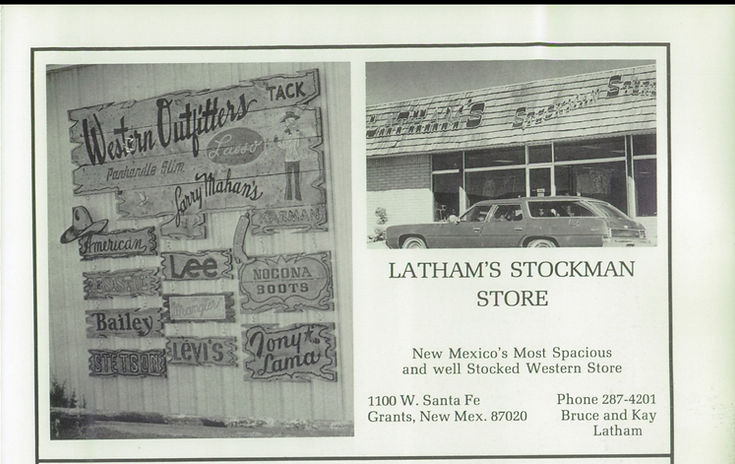
Yucca Hotel postcard, ca. 1927.
A late‑1920s view of the rebuilt Yucca Hotel, showing the barber shop and early automobile traffic during the first years of Route 66.
Artifact: Archival photographs of the 1941 Fourth of July Parade
Source: Cibola County History Museum
Retrieved from: Public post by the Cibola County History Museum on Facebook
Caption: Scenes from the 1941 Fourth of July Parade showing downtown Grants, including the Yucca Café, Cabot Drugs, and early Route 66 streetscape.

1980
Grant — Uranium Capital of the World

Grants Cut and Mt. Taylor
Locomotive 2926 heading west through
Grants Cut
1910
1990
Grant — Uranium Capital of the World

Grants Cut and Mt. Taylor
Locomotive 2926 heading west through
Grants Cut
1103 W. Santa Fe Avenue
Downtown Grants
Phillips 66 Service Station Parcel
Route Shields of Grants-Milan and Surrounding Area
The parcel at 108 W. Santa Fe Avenue developed shortly after the 1937 straightening of Route 66 and became home to one of the block’s earliest mid‑century nightlife venues. By the 1940s, the Tropical Lounge & Junior Bar operated here as a combined bar and cocktail establishment, serving both local residents and travelers using the improved highway.
In the mid‑1950s, the business adopted a new name — the California Bar — but continued operating in the same building with the same function. This bar remained a familiar gathering place on Santa Fe Avenue until the building was removed in 1973 to make way for Pizza Hut.
1912-1926
1912-1926
1926-1948
1948-1961
1961-1971
1971-1985
1912-1927
1927-Present
1972-Present
1985-Present
1985-Present
1985-Present
1985-Present
1985-Present
1991-Present
1998-Present
1998-Present
2010-Present
The Tropical Lounge & Junior Bar, later known as the California Bar, reflects the mid‑century evolution of Santa Fe Avenue. These establishments helped define the social identity of the corridor during the Route 66 era, offering nightlife and entertainment to both locals and motorists.
Founders & Builders (1909-1910)

Simon Bibo
1845 - 1922
Simon Bibo was one of the most influential merchants and community leaders in early New Mexico, part of a pioneering family whose commercial and political reach extended across the entire state. By the time he became involved in the Grants region, Bibo had already established himself as a respected trader, landholder, and civic figure with deep ties to Laguna, Acoma, and the surrounding pueblos. His presence in the early commercial development of Grants reflects the broader impact of the Bibo family on New Mexico’s territorial and early‑statehood economy. Early Life & Immigration Simon Bibo was born in 1845 in Prussia (modern‑day Germany), part of a Jewish family that would become one of the most influential mercantile dynasties in New Mexico. Simon and his brothers — including Solomon, Nathan, and Louis — immigrated to the United States in the mid‑19th century during a period of widespread European migration. Drawn by opportunity and the expanding frontier economy, the Bibo brothers made their way west, eventually settling in the New Mexico Territory. Arrival in New Mexico & Early Mercantile Work By the 1860s and 1870s, the Bibo brothers had established trading posts throughout the region, including at Laguna Pueblo, Acoma Pueblo, and other key points along early transportation routes. Their operations were known for fairness, reliability, and strong relationships with Native communities — a rarity in the era. Simon, like his brothers, became fluent in local languages and customs, earning trust and building long‑term partnerships. Role in Laguna, Acoma, and Regional Trade The Bibo family became deeply integrated into the cultural and economic life of the pueblos. Their trading posts supplied: food tools cloth livestock building materials credit and financial services Simon’s work helped establish a stable commercial network that connected remote communities to the broader territorial economy. Expansion Toward Grants & the Railroad Era When the Atlantic & Pacific Railroad pushed through the region in the 1880s, the Bibo family expanded their operations westward. Simon became involved in land transactions, supply contracts, and commercial development tied to the new rail corridor. By the early 1900s, as Grants began to form around the railroad siding, Simon’s influence extended into: land leasing supply chains early commercial partnerships support for new businesses His presence helped shape the economic foundation of the emerging town. Ties to Early Grants Businesses Although Simon did not own the Yucca or Lux, his mercantile network supplied many early businesses in the region. His connections linked him to: early hotel operators ranching families railroad crews construction contractors territorial‑era merchants The Bibo family’s reach meant that nearly every early business in Grants had some connection — direct or indirect — to their trade network. Political & Civic Influence The Bibo family held numerous civic roles across New Mexico, including: postmasters mayors county officials community negotiators advocates for Native communities Simon himself was known for diplomacy, fairness, and long‑standing relationships with tribal leaders. Later Life & Legacy Simon Bibo died in 1922, leaving behind a legacy that stretched far beyond any single town. His family’s mercantile empire shaped the economic development of western New Mexico for decades, and their influence is still recognized in historical records, community memory, and regional heritage. In Grants, Simon’s legacy is tied to the earliest commercial foundations of the town — a reminder that the community was shaped not only by local builders and business owners, but by regional figures whose work connected the area to the wider world.
Joesph "Joe" Cappelli
1880 - 1973
Joseph “Joe” Cappelli was an Italian‑born stonemason and contractor who helped shape early Grants during its first major boom. Best known for building the Yucca Hotel for George Ade on the former site of Latham’s Stockman’s Store, Cappelli lived only a few blocks from downtown and worked during the years when Grants transformed from a railroad siding into a true town. His craftsmanship produced one of the earliest and most important commercial buildings in Grants — a structure that later became a featured landmark on early Route 66 and the Will Rogers Highway. Early Life & Immigration Simon Bibo was born in 1845 in Prussia (modern‑day Germany), part of a Jewish family that would become one of the most influential mercantile dynasties in New Mexico. Simon and his brothers — including Solomon, Nathan, and Louis — immigrated to the United States in the mid‑19th century during a period of widespread European migration. Drawn by opportunity and the expanding frontier economy, the Bibo brothers made their way west, eventually settling in the New Mexico Territory. Arrival in New Mexico & Early Mercantile Work By the 1860s and 1870s, the Bibo brothers had established trading posts throughout the region, including at Laguna Pueblo, Acoma Pueblo, and other key points along early transportation routes. Their operations were known for fairness, reliability, and strong relationships with Native communities — a rarity in the era. Simon, like his brothers, became fluent in local languages and customs, earning trust and building long‑term partnerships. Role in Laguna, Acoma, and Regional Trade The Bibo family became deeply integrated into the cultural and economic life of the pueblos. Their trading posts supplied: food tools cloth livestock building materials credit and financial services Simon’s work helped establish a stable commercial network that connected remote communities to the broader territorial economy. Expansion Toward Grants & the Railroad Era When the Atlantic & Pacific Railroad pushed through the region in the 1880s, the Bibo family expanded their operations westward. Simon became involved in land transactions, supply contracts, and commercial development tied to the new rail corridor. By the early 1900s, as Grants began to form around the railroad siding, Simon’s influence extended into: land leasing supply chains early commercial partnerships support for new businesses His presence helped shape the economic foundation of the emerging town. Ties to Early Grants Businesses Although Simon did not own the Yucca or Lux, his mercantile network supplied many early businesses in the region. His connections linked him to: early hotel operators ranching families railroad crews construction contractors territorial‑era merchants The Bibo family’s reach meant that nearly every early business in Grants had some connection — direct or indirect — to their trade network. Political & Civic Influence The Bibo family held numerous civic roles across New Mexico, including: postmasters mayors county officials community negotiators advocates for Native communities Simon himself was known for diplomacy, fairness, and long‑standing relationships with tribal leaders. Later Life & Legacy Simon Bibo died in 1922, leaving behind a legacy that stretched far beyond any single town. His family’s mercantile empire shaped the economic development of western New Mexico for decades, and their influence is still recognized in historical records, community memory, and regional heritage. In Grants, Simon’s legacy is tied to the earliest commercial foundations of the town — a reminder that the community was shaped not only by local builders and business owners, but by regional figures whose work connected the area to the wider world.
1930
Grant — Uranium Capital of the World
Grants Cut and Mt. Taylor
Locomotive 2926 heading west through
Grants Cut
Phillips 66 Service Station
1930 - 1990s

Owner: George Ades
Manager:
Phone # 1
1927 — Yucca Hotel Expands Services
By 1927, the Yucca Hotel had become one of Grants’ most reliable lodging houses, offering meals, rooms, and traveler accommodations during the early years of Route 66. Local directory listings from this period show the hotel advertising steady service and dependable management, reflecting its growing role as a community anchor before the major highway boom of the 1930s.
A 1927 directory entry highlights the Yucca Hotel’s early reputation for consistent service and traveler accommodations.
1957 — Street view of Route 66 and
the Yucca Hotel & Conley Motor Co.
Grants, New Mexico
Source: Photographs courtesy of the Cibola County History Museum.
Yucca Hotel postcard, ca. 1927.
A late‑1920s view of the rebuilt Yucca Hotel, showing the barber shop and early automobile traffic during the first years of Route 66.
Artifact: Archival photographs of the 1941 Fourth of July Parade
Source: Cibola County History Museum
Retrieved from: Public post by the Cibola County History Museum on Facebook
Caption: Scenes from the 1941 Fourth of July Parade showing downtown Grants, including the Yucca Café, Cabot Drugs, and early Route 66 streetscape.
1910
1956
Grant — Uranium Capital of the World
Grants Cut and Mt. Taylor
Locomotive 2926 heading west through
Grants Cut
Jolly 66 Service Station
1930 - 1990s
Owner: James W. Holly
Jolly Sixty-Six Oil Co.
Manager:
Phone: AT 7-4291
1927 — Yucca Hotel Expands Services
By 1927, the Yucca Hotel had become one of Grants’ most reliable lodging houses, offering meals, rooms, and traveler accommodations during the early years of Route 66. Local directory listings from this period show the hotel advertising steady service and dependable management, reflecting its growing role as a community anchor before the major highway boom of the 1930s.
A 1927 directory entry highlights the Yucca Hotel’s early reputation for consistent service and traveler accommodations.
1957 — Street view of Route 66 and
the Yucca Hotel & Conley Motor Co.
Grants, New Mexico
Source: Photographs courtesy of the Cibola County History Museum.

Yucca Hotel postcard, ca. 1927.
A late‑1920s view of the rebuilt Yucca Hotel, showing the barber shop and early automobile traffic during the first years of Route 66.
Artifact: Archival photographs of the 1941 Fourth of July Parade
Source: Cibola County History Museum
Retrieved from: Public post by the Cibola County History Museum on Facebook
Caption: Scenes from the 1941 Fourth of July Parade showing downtown Grants, including the Yucca Café, Cabot Drugs, and early Route 66 streetscape.
1962
Grant — Uranium Capital of the World
Grants Cut and Mt. Taylor
Locomotive 2926 heading west through
Grants Cut
Andy's 66 Service Station
1930 - 1990s
Owner: James W. Holly
Holly Sixty-Six Oil Co.
Manager:
Phone: AT 7-4291
1927 — Yucca Hotel Expands Services
By 1927, the Yucca Hotel had become one of Grants’ most reliable lodging houses, offering meals, rooms, and traveler accommodations during the early years of Route 66. Local directory listings from this period show the hotel advertising steady service and dependable management, reflecting its growing role as a community anchor before the major highway boom of the 1930s.
A 1927 directory entry highlights the Yucca Hotel’s early reputation for consistent service and traveler accommodations.
1957 — Street view of Route 66 and
the Yucca Hotel & Conley Motor Co.
Grants, New Mexico
Source: Photographs courtesy of the Cibola County History Museum.

Yucca Hotel postcard, ca. 1927.
A late‑1920s view of the rebuilt Yucca Hotel, showing the barber shop and early automobile traffic during the first years of Route 66.
Artifact: Archival photographs of the 1941 Fourth of July Parade
Source: Cibola County History Museum
Retrieved from: Public post by the Cibola County History Museum on Facebook
Caption: Scenes from the 1941 Fourth of July Parade showing downtown Grants, including the Yucca Café, Cabot Drugs, and early Route 66 streetscape.
1966
Grant — Uranium Capital of the World
Grants Cut and Mt. Taylor
Locomotive 2926 heading west through
Grants Cut
Andy's Sixty-Six Service Station
1930 - 1990s
Owner:
Manager:
Phone: 287-2105
1927 — Yucca Hotel Expands Services
By 1927, the Yucca Hotel had become one of Grants’ most reliable lodging houses, offering meals, rooms, and traveler accommodations during the early years of Route 66. Local directory listings from this period show the hotel advertising steady service and dependable management, reflecting its growing role as a community anchor before the major highway boom of the 1930s.
A 1927 directory entry highlights the Yucca Hotel’s early reputation for consistent service and traveler accommodations.
1957 — Street view of Route 66 and
the Yucca Hotel & Conley Motor Co.
Grants, New Mexico
Source: Photographs courtesy of the Cibola County History Museum.

Yucca Hotel postcard, ca. 1927.
A late‑1920s view of the rebuilt Yucca Hotel, showing the barber shop and early automobile traffic during the first years of Route 66.
Artifact: Archival photographs of the 1941 Fourth of July Parade
Source: Cibola County History Museum
Retrieved from: Public post by the Cibola County History Museum on Facebook
Caption: Scenes from the 1941 Fourth of July Parade showing downtown Grants, including the Yucca Café, Cabot Drugs, and early Route 66 streetscape.
1968
Grant — Uranium Capital of the World
Grants Cut and Mt. Taylor
Locomotive 2926 heading west through
Grants Cut
Andy's Sixty-Six Service Station
1930 - 1990s
Owner:
Manager:
Phone: 287-2105
1927 — Yucca Hotel Expands Services
By 1927, the Yucca Hotel had become one of Grants’ most reliable lodging houses, offering meals, rooms, and traveler accommodations during the early years of Route 66. Local directory listings from this period show the hotel advertising steady service and dependable management, reflecting its growing role as a community anchor before the major highway boom of the 1930s.
A 1927 directory entry highlights the Yucca Hotel’s early reputation for consistent service and traveler accommodations.
1957 — Street view of Route 66 and
the Yucca Hotel & Conley Motor Co.
Grants, New Mexico
Source: Photographs courtesy of the Cibola County History Museum.
Yucca Hotel postcard, ca. 1927.
A late‑1920s view of the rebuilt Yucca Hotel, showing the barber shop and early automobile traffic during the first years of Route 66.
Artifact: Archival photographs of the 1941 Fourth of July Parade
Source: Cibola County History Museum
Retrieved from: Public post by the Cibola County History Museum on Facebook
Caption: Scenes from the 1941 Fourth of July Parade showing downtown Grants, including the Yucca Café, Cabot Drugs, and early Route 66 streetscape.
1111 W. Santa Fe Avenue
Downtown Grants
C & C Auto Sales Parcel
The building at 110 W. Santa Fe Avenue was constructed in the late 1960s on the west end of the former Tropical Lounge/California Bar parcel. This subdivision occurred before the bar was demolished, and the new structure appears in late‑1960s photographs of the California Bar.
The first documented tenant was Pacific Finance, which relocated here by 1973 after previously operating at 807 W. Santa Fe Avenue in 1966, 1967, and 1968. Over the next five decades, the building housed a sequence of small professional, retail, and service businesses that reflect the changing needs of Grants residents as Santa Fe Avenue transitioned from a Route 66 travel corridor into a locally focused business district.
1912-1926
1912-1926
1926-1948
1948-1961
1961-1971
1971-1985
1912-1927
1927-Present
1972-Present
1985-Present
1985-Present
1985-Present
1985-Present
1985-Present
1991-Present
1998-Present
1998-Present
2010-Present
The development of 110 W. Santa Fe reflects the final wave of mid‑century infill along the 100 block, providing new commercial space as Grants expanded and diversified.
1976
Grant — Uranium Capital of the World
Grants Cut and Mt. Taylor
Locomotive 2926 heading west through
Grants Cut
C and C AUTO SALES
1976 - 1978
Owner:
Manager:
Phone: 287-2320
1927 — Yucca Hotel Expands Services
By 1927, the Yucca Hotel had become one of Grants’ most reliable lodging houses, offering meals, rooms, and traveler accommodations during the early years of Route 66. Local directory listings from this period show the hotel advertising steady service and dependable management, reflecting its growing role as a community anchor before the major highway boom of the 1930s.
A 1927 directory entry highlights the Yucca Hotel’s early reputation for consistent service and traveler accommodations.
1957 — Street view of Route 66 and
the Yucca Hotel & Conley Motor Co.
Grants, New Mexico
Source: Photographs courtesy of the Cibola County History Museum.
Yucca Hotel postcard, ca. 1927.
A late‑1920s view of the rebuilt Yucca Hotel, showing the barber shop and early automobile traffic during the first years of Route 66.
Artifact: Archival photographs of the 1941 Fourth of July Parade
Source: Cibola County History Museum
Retrieved from: Public post by the Cibola County History Museum on Facebook
Caption: Scenes from the 1941 Fourth of July Parade showing downtown Grants, including the Yucca Café, Cabot Drugs, and early Route 66 streetscape.
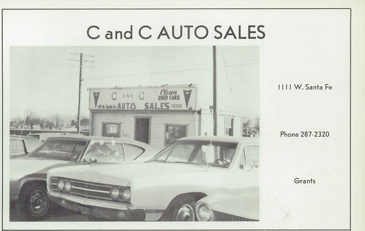
1112 W. Santa Fe Avenue
Downtown Grants
Grants Theatre Parcel
The building at 110 W. Santa Fe Avenue was constructed in the late 1960s on the west end of the former Tropical Lounge/California Bar parcel. This subdivision occurred before the bar was demolished, and the new structure appears in late‑1960s photographs of the California Bar.
The first documented tenant was Pacific Finance, which relocated here by 1973 after previously operating at 807 W. Santa Fe Avenue in 1966, 1967, and 1968. Over the next five decades, the building housed a sequence of small professional, retail, and service businesses that reflect the changing needs of Grants residents as Santa Fe Avenue transitioned from a Route 66 travel corridor into a locally focused business district.
1912-1926
1912-1926
1926-1948
1948-1961
1961-1971
1971-1985
1912-1927
1927-Present
1972-Present
1985-Present
1985-Present
1985-Present
1985-Present
1985-Present
1991-Present
1998-Present
1998-Present
2010-Present
The development of 110 W. Santa Fe reflects the final wave of mid‑century infill along the 100 block, providing new commercial space as Grants expanded and diversified.
1910
1917
Grant — Uranium Capital of the World
Grants Cut and Mt. Taylor
Locomotive 2926 heading west through
Grants Cut
1114 W. Santa Fe Avenue
Downtown Grants
White Arrow Garage Parcel
The building at 110 W. Santa Fe Avenue was constructed in the late 1960s on the west end of the former Tropical Lounge/California Bar parcel. This subdivision occurred before the bar was demolished, and the new structure appears in late‑1960s photographs of the California Bar.
The first documented tenant was Pacific Finance, which relocated here by 1973 after previously operating at 807 W. Santa Fe Avenue in 1966, 1967, and 1968. Over the next five decades, the building housed a sequence of small professional, retail, and service businesses that reflect the changing needs of Grants residents as Santa Fe Avenue transitioned from a Route 66 travel corridor into a locally focused business district.
1912-1926
1912-1926
1926-1948
1948-1961
1961-1971
1971-1985
1912-1927
1927-Present
1972-Present
1985-Present
1985-Present
1985-Present
1985-Present
1985-Present
1991-Present
1998-Present
1998-Present
2010-Present
The development of 110 W. Santa Fe reflects the final wave of mid‑century infill along the 100 block, providing new commercial space as Grants expanded and diversified.
1912
Grant — Uranium Capital of the World
Grants Cut and Mt. Taylor
Locomotive 2926 heading west through
Grants Cut
White Arrow Garage
1930 - 1990s
Owner:
Manager:
Phone: 287-2105
1927 — Yucca Hotel Expands Services
By 1927, the Yucca Hotel had become one of Grants’ most reliable lodging houses, offering meals, rooms, and traveler accommodations during the early years of Route 66. Local directory listings from this period show the hotel advertising steady service and dependable management, reflecting its growing role as a community anchor before the major highway boom of the 1930s.
A 1927 directory entry highlights the Yucca Hotel’s early reputation for consistent service and traveler accommodations.
1957 — Street view of Route 66 and
the Yucca Hotel & Conley Motor Co.
Grant, New Mexico
Source: Photographs courtesy of the Cibola County History Museum.
Yucca Hotel postcard, ca. 1927.
A late‑1920s view of the rebuilt Yucca Hotel, showing the barber shop and early automobile traffic during the first years of Route 66.
Artifact: Archival photographs of the 1941 Fourth of July Parade
Source: Cibola County History Museum
Retrieved from: Public post by the Cibola County History Museum on Facebook
Caption: Scenes from the 1941 Fourth of July Parade showing downtown Grants, including the Yucca Café, Cabot Drugs, and early Route 66 streetscape.
1913
Grant — Uranium Capital of the World
Grants Cut and Mt. Taylor
Locomotive 2926 heading west through
Grants Cut
White Arrow Garage
1930 - 1990s
Owner:
Manager: R. C. Elston
Phone: None
1927 — Yucca Hotel Expands Services
By 1927, the Yucca Hotel had become one of Grants’ most reliable lodging houses, offering meals, rooms, and traveler accommodations during the early years of Route 66. Local directory listings from this period show the hotel advertising steady service and dependable management, reflecting its growing role as a community anchor before the major highway boom of the 1930s.
A 1927 directory entry highlights the Yucca Hotel’s early reputation for consistent service and traveler accommodations.
1913 — Business Listing Catalogue
White Arrow Garage
Grant, New Mexico
Source: Photographs courtesy of the Cibola County History Museum.
Yucca Hotel postcard, ca. 1927.
A late‑1920s view of the rebuilt Yucca Hotel, showing the barber shop and early automobile traffic during the first years of Route 66.
Artifact: Archival photographs of the 1941 Fourth of July Parade
Source: Cibola County History Museum
Retrieved from: Public post by the Cibola County History Museum on Facebook
Caption: Scenes from the 1941 Fourth of July Parade showing downtown Grants, including the Yucca Café, Cabot Drugs, and early Route 66 streetscape.
1920
Grant — Uranium Capital of the World
Grants Cut and Mt. Taylor
Locomotive 2926 heading west through
Grants Cut
White Arrow Garage
1930 - 1990s
Owner:
Manager:
Phone: 287-2105
1927 — Yucca Hotel Expands Services
By 1927, the Yucca Hotel had become one of Grants’ most reliable lodging houses, offering meals, rooms, and traveler accommodations during the early years of Route 66. Local directory listings from this period show the hotel advertising steady service and dependable management, reflecting its growing role as a community anchor before the major highway boom of the 1930s.
A 1927 directory entry highlights the Yucca Hotel’s early reputation for consistent service and traveler accommodations.
1920 — White Arrow Garage
&
Standard Oil Products
Grant, New Mexico
Source: Photographs courtesy of the Cibola County History Museum.

Yucca Hotel postcard, ca. 1927.
A late‑1920s view of the rebuilt Yucca Hotel, showing the barber shop and early automobile traffic during the first years of Route 66.
Artifact: Archival photographs of the 1941 Fourth of July Parade
Source: Cibola County History Museum
Retrieved from: Public post by the Cibola County History Museum on Facebook
Caption: Scenes from the 1941 Fourth of July Parade showing downtown Grants, including the Yucca Café, Cabot Drugs, and early Route 66 streetscape.
1929
Grant — Uranium Capital of the World
Grants Cut and Mt. Taylor
Locomotive 2926 heading west through
Grants Cut
White Arrow Garage
1930 - 1990s
Owner:
Manager:
Phone: 287-2105
1927 — Yucca Hotel Expands Services
By 1927, the Yucca Hotel had become one of Grants’ most reliable lodging houses, offering meals, rooms, and traveler accommodations during the early years of Route 66. Local directory listings from this period show the hotel advertising steady service and dependable management, reflecting its growing role as a community anchor before the major highway boom of the 1930s.
A 1927 directory entry highlights the Yucca Hotel’s early reputation for consistent service and traveler accommodations.
1929 — Albuquerque Journal want ad for
White Arrow Garage
Grant, New Mexico
Source: Photographs courtesy of the Cibola County History Museum.
May 9, 1929

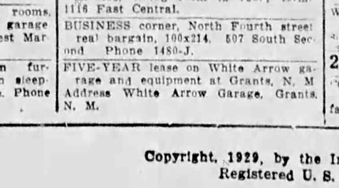
Yucca Hotel postcard, ca. 1927.
A late‑1920s view of the rebuilt Yucca Hotel, showing the barber shop and early automobile traffic during the first years of Route 66.
Artifact: Archival photographs of the 1941 Fourth of July Parade
Source: Cibola County History Museum
Retrieved from: Public post by the Cibola County History Museum on Facebook
Caption: Scenes from the 1941 Fourth of July Parade showing downtown Grants, including the Yucca Café, Cabot Drugs, and early Route 66 streetscape.
1910
1936
Grant — Uranium Capital of the World
Grants Cut and Mt. Taylor
Locomotive 2926 heading west through
Grants Cut
White Arrow Garage
1930 - 1990s
Owner and General Manager: Red Prestridge
Mechanical Department: Paul Blackburn
Ford Salesman: R. L. King
Phone: 22
1927 — Yucca Hotel Expands Services
By 1927, the Yucca Hotel had become one of Grants’ most reliable lodging houses, offering meals, rooms, and traveler accommodations during the early years of Route 66. Local directory listings from this period show the hotel advertising steady service and dependable management, reflecting its growing role as a community anchor before the major highway boom of the 1930s.
A 1927 directory entry highlights the Yucca Hotel’s early reputation for consistent service and traveler accommodations.
1936 — The Gallup Independent
article for
White Arrow Garage
Grants, New Mexico
Source: Photographs courtesy of the Cibola County History Museum.
The Gallup Independent
January 27, 1936
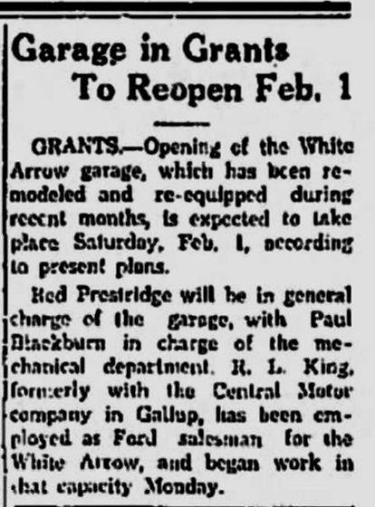
Yucca Hotel postcard, ca. 1927.
A late‑1920s view of the rebuilt Yucca Hotel, showing the barber shop and early automobile traffic during the first years of Route 66.
Artifact: Archival photographs of the 1941 Fourth of July Parade
Source: Cibola County History Museum
Retrieved from: Public post by the Cibola County History Museum on Facebook
Caption: Scenes from the 1941 Fourth of July Parade showing downtown Grants, including the Yucca Café, Cabot Drugs, and early Route 66 streetscape.
1940
Grant — Uranium Capital of the World
Grants Cut and Mt. Taylor
Locomotive 2926 heading west through
Grants Cut
White Arrow Garage
1930 - 1990s
Owner: Navajo Chevrolet Co. (Gallup)
Manager: Bill Dye
Mechanical Department:
Chevrolet Salesman:
Phone: 22
1927 — Yucca Hotel Expands Services
By 1927, the Yucca Hotel had become one of Grants’ most reliable lodging houses, offering meals, rooms, and traveler accommodations during the early years of Route 66. Local directory listings from this period show the hotel advertising steady service and dependable management, reflecting its growing role as a community anchor before the major highway boom of the 1930s.
A 1927 directory entry highlights the Yucca Hotel’s early reputation for consistent service and traveler accommodations.
1940 — The Gallup Independent want ad for the White Arrow Garage
Grants, New Mexico
Source: Photographs courtesy of the Cibola County History Museum.
The Gallup Independent
December 10, 1940

Yucca Hotel postcard, ca. 1927.
A late‑1920s view of the rebuilt Yucca Hotel, showing the barber shop and early automobile traffic during the first years of Route 66.
Artifact: Archival photographs of the 1941 Fourth of July Parade
Source: Cibola County History Museum
Retrieved from: Public post by the Cibola County History Museum on Facebook
Caption: Scenes from the 1941 Fourth of July Parade showing downtown Grants, including the Yucca Café, Cabot Drugs, and early Route 66 streetscape.
1910
1956
Grant — Uranium Capital of the World
Grants Cut and Mt. Taylor
Locomotive 2926 heading west through
Grants Cut
McMains Motor Co.
1930 - 1990s


Owner: McMains Motor Co.
Owner: O. L. McMains
Phone: 287-4771
Phone: 287-4730
ABCO Rent-A-Car Center
1930 - 1990s
Owner: McMains Motor Co.
Owner: O. L. McMains
Phone: 287-4771
1927 — Yucca Hotel Expands Services
By 1927, the Yucca Hotel had become one of Grants’ most reliable lodging houses, offering meals, rooms, and traveler accommodations during the early years of Route 66. Local directory listings from this period show the hotel advertising steady service and dependable management, reflecting its growing role as a community anchor before the major highway boom of the 1930s.
A 1927 directory entry highlights the Yucca Hotel’s early reputation for consistent service and traveler accommodations.
1956 — Grants High School
"Pirates Ahoy" sponsor ad and white page listings for
McMains Motor Co.
Grants, New Mexico
Source: Photographs courtesy of the Cibola County History Museum.
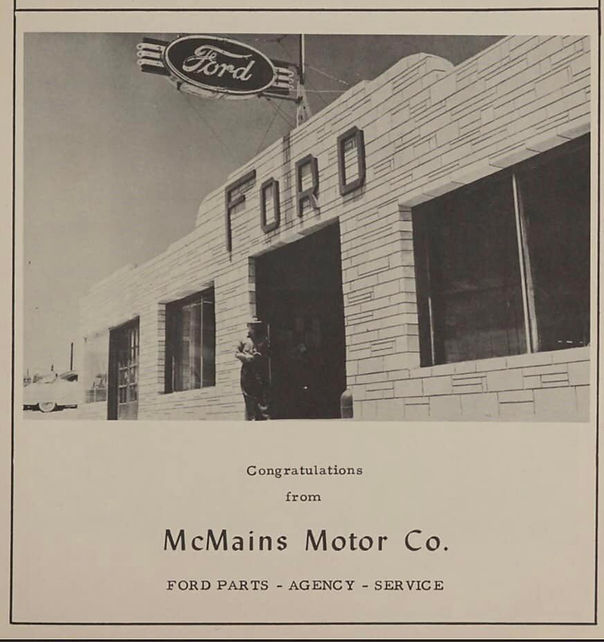
1956 Grants High School "Pirates Ahoy"
Sponsor ad for McMains Motor Co.
Grants, New Mexico

1956 Mountain States Tel & Tel Co.
White page listing for
McMain's Motor Co.
Grants, New Mexico

1956 Mountain States Tel & Tel Co.
White page listing for
ABCO RENT-A-CAR SYSTEM
Grants, New Mexico
Artifact: Archival photographs of the 1941 Fourth of July Parade
Source: Cibola County History Museum
Retrieved from: Public post by the Cibola County History Museum on Facebook
Caption: Scenes from the 1941 Fourth of July Parade showing downtown Grants, including the Yucca Café, Cabot Drugs, and early Route 66 streetscape.
1958
Grant — Uranium Capital of the World
Grants Cut and Mt. Taylor
Locomotive 2926 heading west through
Grants Cut
CONLEY MOTOR COMPANY
1930 - 1990s
Owner: Harley Conley
Manager:
Service Department:
Day Phone: AT 7-4771
Night Phone, 24-Hour Wrecker Service: AT 7-4185
1927 — Yucca Hotel Expands Services
By 1927, the Yucca Hotel had become one of Grants’ most reliable lodging houses, offering meals, rooms, and traveler accommodations during the early years of Route 66. Local directory listings from this period show the hotel advertising steady service and dependable management, reflecting its growing role as a community anchor before the major highway boom of the 1930s.
1958 — This is Grants brochure ad for Conely Motor Co.
Grants, New Mexico
Source: Photographs courtesy of the Cibola County History Museum.
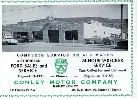
Conley Motor Company
Published by:“This is Grants” booklet, compiled and published by Manly W Lutz Publications Advertising ABQ NM. 1958 volume 1, number 1.
Artifact: Archival photographs of the 1941 Fourth of July Parade
Source: Cibola County History Museum
Retrieved from: Public post by the Cibola County History Museum on Facebook
Caption: Scenes from the 1941 Fourth of July Parade showing downtown Grants, including the Yucca Café, Cabot Drugs, and early Route 66 streetscape.
A 1927 directory entry highlights the Yucca Hotel’s early reputation for consistent service and traveler accommodations.
1963
Grant — Uranium Capital of the World
Grants Cut and Mt. Taylor
Locomotive 2926 heading west through
Grants Cut
CONLEY MOTOR COMPANY
1930 - 1990s

Owner: Harley Conley
Manager:
Service Department:
Day Phone: AT 7 - 4771
Night Phone, 24-Hour Wrecker Service: AT 7 - 4185
1927 — Yucca Hotel Expands Services
By 1927, the Yucca Hotel had become one of Grants’ most reliable lodging houses, offering meals, rooms, and traveler accommodations during the early years of Route 66. Local directory listings from this period show the hotel advertising steady service and dependable management, reflecting its growing role as a community anchor before the major highway boom of the 1930s.
1963 — Grants High School
"Pirate's Ahoy" sponsor ad
Grants, New Mexico
Source: Photographs courtesy of the Cibola County History Museum.
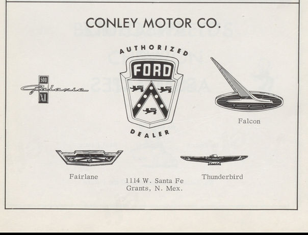
1956 -- Grants High School "Pirates Ahoy"
Sponsor ad for
Conley Motor Co.
Grants, New Mexico
Artifact: Archival photographs of the 1941 Fourth of July Parade
Source: Cibola County History Museum
Retrieved from: Public post by the Cibola County History Museum on Facebook
Caption: Scenes from the 1941 Fourth of July Parade showing downtown Grants, including the Yucca Café, Cabot Drugs, and early Route 66 streetscape.
A 1927 directory entry highlights the Yucca Hotel’s early reputation for consistent service and traveler accommodations.
1967
Grant — Uranium Capital of the World
Grants Cut and Mt. Taylor
Locomotive 2926 heading west through
Grants Cut
CIBOLA MOTORS INC.
1930 - 1990s
Owner: Harley Conley
Manager:
Service Department:
Day Phone: 287-4428
1927 — Yucca Hotel Expands Services
By 1927, the Yucca Hotel had become one of Grants’ most reliable lodging houses, offering meals, rooms, and traveler accommodations during the early years of Route 66. Local directory listings from this period show the hotel advertising steady service and dependable management, reflecting its growing role as a community anchor before the major highway boom of the 1930s.
A 1927 directory entry highlights the Yucca Hotel’s early reputation for consistent service and traveler accommodations.
1967 — This is Grants brochure ad for Cibola Motors Inc.
Grants, New Mexico
Source: Courtesy of Patricia McClure
1956 -- Grants High School "Pirates Ahoy"
Sponsor ad for Cibola Motor Inc.
Grants, New Mexico
Artifact: Archival photographs of the 1941 Fourth of July Parade
Source: Cibola County History Museum
Retrieved from: Public post by the Cibola County History Museum on Facebook
Caption: Scenes from the 1941 Fourth of July Parade showing downtown Grants, including the Yucca Café, Cabot Drugs, and early Route 66 streetscape.
1969
Grant — Uranium Capital of the World
Grants Cut and Mt. Taylor
Locomotive 2926 heading west through
Grants Cut
CIBOLA MOTORS INC.
1930 - 1990s
Owner: Harley Conley
Manager:
Service Department:
Day Phone: 287-4428
1927 — Yucca Hotel Expands Services
By 1927, the Yucca Hotel had become one of Grants’ most reliable lodging houses, offering meals, rooms, and traveler accommodations during the early years of Route 66. Local directory listings from this period show the hotel advertising steady service and dependable management, reflecting its growing role as a community anchor before the major highway boom of the 1930s.
A 1927 directory entry highlights the Yucca Hotel’s early reputation for consistent service and traveler accommodations.
1969 — This is Grants brochure ad for Cibola Motors Inc.
Grants, New Mexico
Source: Courtesy of Patricia McClure
1969 -- Grants High School "Pirates Ahoy"
Sponsor ad for Cibola Motor Inc.
Grants, New Mexico
Artifact: Archival photographs of the 1941 Fourth of July Parade
Source: Cibola County History Museum
Retrieved from: Public post by the Cibola County History Museum on Facebook
Caption: Scenes from the 1941 Fourth of July Parade showing downtown Grants, including the Yucca Café, Cabot Drugs, and early Route 66 streetscape.


1968

Valencia County
Grants — New Mexico

1115 W. Santa Fe Avenue
Downtown Grants
S. Bibo Bros. Mercantile Parcel
The building at 110 W. Santa Fe Avenue was constructed in the late 1960s on the west end of the former Tropical Lounge/California Bar parcel. This subdivision occurred before the bar was demolished, and the new structure appears in late‑1960s photographs of the California Bar.
The first documented tenant was Pacific Finance, which relocated here by 1973 after previously operating at 807 W. Santa Fe Avenue in 1966, 1967, and 1968. Over the next five decades, the building housed a sequence of small professional, retail, and service businesses that reflect the changing needs of Grants residents as Santa Fe Avenue transitioned from a Route 66 travel corridor into a locally focused business district.
1912-1926
1912-1926
1926-1948
1948-1961
1961-1971
1971-1985
1912-1927
1927-Present
1972-Present
1985-Present
1985-Present
1985-Present
1985-Present
1985-Present
1991-Present
1998-Present
1998-Present
2010-Present
Route Shields Timeline
Grants-Milan and Surrounding Areas
The development of 110 W. Santa Fe reflects the final wave of mid‑century infill along the 100 block, providing new commercial space as Grants expanded and diversified.
Founders & Builders (1881-1970)
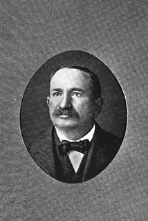
Simon Bibo
1845 - 1922
Simon Bibo was one of the most influential merchants and community leaders in early New Mexico, part of a pioneering family whose commercial and political reach extended across the entire state. By the time he became involved in the Grants region, Bibo had already established himself as a respected trader, landholder, and civic figure with deep ties to Laguna, Acoma, and the surrounding pueblos. His presence in the early commercial development of Grants reflects the broader impact of the Bibo family on New Mexico’s territorial and early‑statehood economy. Early Life & Immigration Simon Bibo was born in 1845 in Prussia (modern‑day Germany), part of a Jewish family that would become one of the most influential mercantile dynasties in New Mexico. Simon and his brothers — including Solomon, Nathan, and Louis — immigrated to the United States in the mid‑19th century during a period of widespread European migration. Drawn by opportunity and the expanding frontier economy, the Bibo brothers made their way west, eventually settling in the New Mexico Territory. Arrival in New Mexico & Early Mercantile Work By the 1860s and 1870s, the Bibo brothers had established trading posts throughout the region, including at Laguna Pueblo, Acoma Pueblo, and other key points along early transportation routes. Their operations were known for fairness, reliability, and strong relationships with Native communities — a rarity in the era. Simon, like his brothers, became fluent in local languages and customs, earning trust and building long‑term partnerships. Role in Laguna, Acoma, and Regional Trade The Bibo family became deeply integrated into the cultural and economic life of the pueblos. Their trading posts supplied: food tools cloth livestock building materials credit and financial services Simon’s work helped establish a stable commercial network that connected remote communities to the broader territorial economy. Expansion Toward Grants & the Railroad Era When the Atlantic & Pacific Railroad pushed through the region in the 1880s, the Bibo family expanded their operations westward. Simon became involved in land transactions, supply contracts, and commercial development tied to the new rail corridor. By the early 1900s, as Grants began to form around the railroad siding, Simon’s influence extended into: land leasing supply chains early commercial partnerships support for new businesses His presence helped shape the economic foundation of the emerging town. Ties to Early Grants Businesses Although Simon did not own the Yucca or Lux, his mercantile network supplied many early businesses in the region. His connections linked him to: early hotel operators ranching families railroad crews construction contractors territorial‑era merchants The Bibo family’s reach meant that nearly every early business in Grants had some connection — direct or indirect — to their trade network. Political & Civic Influence The Bibo family held numerous civic roles across New Mexico, including: postmasters mayors county officials community negotiators advocates for Native communities Simon himself was known for diplomacy, fairness, and long‑standing relationships with tribal leaders. Later Life & Legacy Simon Bibo died in 1922, leaving behind a legacy that stretched far beyond any single town. His family’s mercantile empire shaped the economic development of western New Mexico for decades, and their influence is still recognized in historical records, community memory, and regional heritage. In Grants, Simon’s legacy is tied to the earliest commercial foundations of the town — a reminder that the community was shaped not only by local builders and business owners, but by regional figures whose work connected the area to the wider world.
Joesph "Joe" Cappelli
1880 - 1973
Joseph “Joe” Cappelli was an Italian‑born stonemason and contractor who helped shape early Grants during its first major boom. Best known for building the Yucca Hotel for George Ade on the former site of Latham’s Stockman’s Store, Cappelli lived only a few blocks from downtown and worked during the years when Grants transformed from a railroad siding into a true town. His craftsmanship produced one of the earliest and most important commercial buildings in Grants — a structure that later became a featured landmark on early Route 66 and the Will Rogers Highway. Early Life & Immigration Simon Bibo was born in 1845 in Prussia (modern‑day Germany), part of a Jewish family that would become one of the most influential mercantile dynasties in New Mexico. Simon and his brothers — including Solomon, Nathan, and Louis — immigrated to the United States in the mid‑19th century during a period of widespread European migration. Drawn by opportunity and the expanding frontier economy, the Bibo brothers made their way west, eventually settling in the New Mexico Territory. Arrival in New Mexico & Early Mercantile Work By the 1860s and 1870s, the Bibo brothers had established trading posts throughout the region, including at Laguna Pueblo, Acoma Pueblo, and other key points along early transportation routes. Their operations were known for fairness, reliability, and strong relationships with Native communities — a rarity in the era. Simon, like his brothers, became fluent in local languages and customs, earning trust and building long‑term partnerships. Role in Laguna, Acoma, and Regional Trade The Bibo family became deeply integrated into the cultural and economic life of the pueblos. Their trading posts supplied: food tools cloth livestock building materials credit and financial services Simon’s work helped establish a stable commercial network that connected remote communities to the broader territorial economy. Expansion Toward Grants & the Railroad Era When the Atlantic & Pacific Railroad pushed through the region in the 1880s, the Bibo family expanded their operations westward. Simon became involved in land transactions, supply contracts, and commercial development tied to the new rail corridor. By the early 1900s, as Grants began to form around the railroad siding, Simon’s influence extended into: land leasing supply chains early commercial partnerships support for new businesses His presence helped shape the economic foundation of the emerging town. Ties to Early Grants Businesses Although Simon did not own the Yucca or Lux, his mercantile network supplied many early businesses in the region. His connections linked him to: early hotel operators ranching families railroad crews construction contractors territorial‑era merchants The Bibo family’s reach meant that nearly every early business in Grants had some connection — direct or indirect — to their trade network. Political & Civic Influence The Bibo family held numerous civic roles across New Mexico, including: postmasters mayors county officials community negotiators advocates for Native communities Simon himself was known for diplomacy, fairness, and long‑standing relationships with tribal leaders. Later Life & Legacy Simon Bibo died in 1922, leaving behind a legacy that stretched far beyond any single town. His family’s mercantile empire shaped the economic development of western New Mexico for decades, and their influence is still recognized in historical records, community memory, and regional heritage. In Grants, Simon’s legacy is tied to the earliest commercial foundations of the town — a reminder that the community was shaped not only by local builders and business owners, but by regional figures whose work connected the area to the wider world.
1881
Grant's Camp - New Mexico Territory
Grants Cut and Mt. Taylor
Locomotive 2926 heading west through
Grants Cut

S. BIBO MERCANTILE CO.
1881 - 1970s
Owner: Simon Bibo
Manager:
Service Department:
Day Phone: 287-4428
1927 — Yucca Hotel Expands Services
By 1927, the Yucca Hotel had become one of Grants’ most reliable lodging houses, offering meals, rooms, and traveler accommodations during the early years of Route 66. Local directory listings from this period show the hotel advertising steady service and dependable management, reflecting its growing role as a community anchor before the major highway boom of the 1930s.
1969 — This is Grants brochure ad for Cibola Motors Inc.
Grants, New Mexico
Source: Courtesy of Patricia McClure
1969 -- Grants High School "Pirates Ahoy"
Sponsor ad for Cibola Motor Inc.
Grants, New Mexico
Artifact: Archival photographs of the 1941 Fourth of July Parade
Source: Cibola County History Museum
Retrieved from: Public post by the Cibola County History Museum on Facebook
Caption: Scenes from the 1941 Fourth of July Parade showing downtown Grants, including the Yucca Café, Cabot Drugs, and early Route 66 streetscape.
A 1927 directory entry highlights the Yucca Hotel’s early reputation for consistent service and traveler accommodations.
1882
Grant's Camp - New Mexico Territory
Grants Cut and Mt. Taylor
Locomotive 2926 heading west through
Grants Cut
S. BIBO MERCANTILE CO.
1881 - 1970s
Owner: Simon Bibo
Manager:
Service Department:
Day Phone: 287-4428
1927 — Yucca Hotel Expands Services
By 1927, the Yucca Hotel had become one of Grants’ most reliable lodging houses, offering meals, rooms, and traveler accommodations during the early years of Route 66. Local directory listings from this period show the hotel advertising steady service and dependable management, reflecting its growing role as a community anchor before the major highway boom of the 1930s.
1882 — This is Grants brochure ad for Cibola Motors Inc.
Grants, New Mexico
Source: Courtesy of Patricia McClure
1969 -- Grants High School "Pirates Ahoy"
Sponsor ad for Cibola Motor Inc.
Grants, New Mexico
Artifact: Archival photographs of the 1941 Fourth of July Parade
Source: Cibola County History Museum
Retrieved from: Public post by the Cibola County History Museum on Facebook
Caption: Scenes from the 1941 Fourth of July Parade showing downtown Grants, including the Yucca Café, Cabot Drugs, and early Route 66 streetscape.
A 1927 directory entry highlights the Yucca Hotel’s early reputation for consistent service and traveler accommodations.
1884
Grant's Camp - New Mexico Territory
Grants Cut and Mt. Taylor
Locomotive 2926 heading west through
Grants Cut
S. BIBO MERCANTILE CO.
1881 - 1970s
Owner: Simon Bibo
Manager:
Service Department:
Day Phone: 287-4428
POST OFFICE (1st Post Office)
1881 - 1930s
Postmaster: Simon Bibo
Western Union Express, Wells Fargo & Co.
1881 - 1930s
Agent: William Webb
1927 — Yucca Hotel Expands Services
By 1927, the Yucca Hotel had become one of Grants’ most reliable lodging houses, offering meals, rooms, and traveler accommodations during the early years of Route 66. Local directory listings from this period show the hotel advertising steady service and dependable management, reflecting its growing role as a community anchor before the major highway boom of the 1930s.
A 1927 directory entry highlights the Yucca Hotel’s early reputation for consistent service and traveler accommodations.
1884 — Business Listing Catalogue for
S. Bibo Mercantile
Grant, New Mexico Territory
Source: Courtesy of Patricia McClure
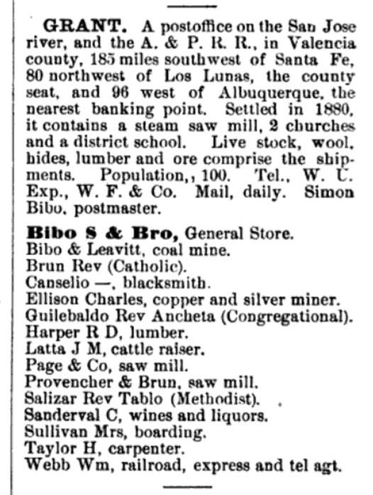
1969 -- Grants High School "Pirates Ahoy"
Sponsor ad for Cibola Motor Inc.
Grants, New Mexico
1969 -- Grants High School "Pirates Ahoy"
Sponsor ad for Cibola Motor Inc.
Grants, New Mexico
Artifact: Archival photographs of the 1941 Fourth of July Parade
Source: Cibola County History Museum
Retrieved from: Public post by the Cibola County History Museum on Facebook
Caption: Scenes from the 1941 Fourth of July Parade showing downtown Grants, including the Yucca Café, Cabot Drugs, and early Route 66 streetscape.
1903
Grant's Camp - New Mexico Territory
Grants Cut and Mt. Taylor
Locomotive 2926 heading west through
Grants Cut
S. BIBO MERCANTILE CO.
1881 - 1970s
Owner: Simon Bibo
Manager: Charles Neustadt
Phone: None
POST OFFICE (1st Post Office)
1881 - 1930s
Postmaster: Simon Bibo
Western Union Express, Wells Fargo & Co.
1881 - 1930s
Agent: William Webb
Stage Coaches
1903 - 1930s
Stage to San Mateo: Jesus Blea
Stage to Cooperton: Narcisco Vallejos
1927 — Yucca Hotel Expands Services
By 1927, the Yucca Hotel had become one of Grants’ most reliable lodging houses, offering meals, rooms, and traveler accommodations during the early years of Route 66. Local directory listings from this period show the hotel advertising steady service and dependable management, reflecting its growing role as a community anchor before the major highway boom of the 1930s.
1903 — Business Listing Catalogue for
S. Bibo Mercantile
Grant, New Mexico Territory
Source: Courtesy of Patricia McClure
1969 -- Grants High School "Pirates Ahoy"
Sponsor ad for Cibola Motor Inc.
Grants, New Mexico
Artifact: Archival photographs of the 1941 Fourth of July Parade
Source: Cibola County History Museum
Retrieved from: Public post by the Cibola County History Museum on Facebook
Caption: Scenes from the 1941 Fourth of July Parade showing downtown Grants, including the Yucca Café, Cabot Drugs, and early Route 66 streetscape.
A 1927 directory entry highlights the Yucca Hotel’s early reputation for consistent service and traveler accommodations.
1905
Grant's Camp - New Mexico Territory
Grants Cut and Mt. Taylor
Locomotive 2926 heading west through
Grants Cut
S. BIBO MERCANTILE CO.
1881 - 1970s
Owner: Simon Bibo
Manager: Charles Neustadt
Phone: None
POST OFFICE (1st Post Office)
1881 - 1930s
Postmaster: Charles Neustadt
Justice of the Peace
1881 - 1930s
Justice of the Peace: Charles Neustadt
Western Union Express, Wells Fargo & Co.
1881 - 1930s
Agent: William Webb
Stage Coaches
1903 - 1930s
Stage to San Mateo: Jesus Blea
Stage to Cooperton: Narcisco Vallejos
1905 — Business Listing Catalogue for
S. Bibo Mercantile
Grant, New Mexico Territory
Source: Courtesy of Patricia McClure

1969 -- Grants High School "Pirates Ahoy"
Sponsor ad for Cibola Motor Inc.
Grants, New Mexico
Artifact: Archival photographs of the 1941 Fourth of July Parade
Source: Cibola County History Museum
Retrieved from: Public post by the Cibola County History Museum on Facebook
Caption: Scenes from the 1941 Fourth of July Parade showing downtown Grants, including the Yucca Café, Cabot Drugs, and early Route 66 streetscape.
1927 — Yucca Hotel Expands Services
By 1927, the Yucca Hotel had become one of Grants’ most reliable lodging houses, offering meals, rooms, and traveler accommodations during the early years of Route 66. Local directory listings from this period show the hotel advertising steady service and dependable management, reflecting its growing role as a community anchor before the major highway boom of the 1930s.
A 1927 directory entry highlights the Yucca Hotel’s early reputation for consistent service and traveler accommodations.
1913
Grant's Camp - New Mexico Territory
Grants Cut and Mt. Taylor
Locomotive 2926 heading west through
Grants Cut
S. BIBO MERCANTILE CO.
1881 - 1970s
Owner: Simon Bibo
Manager: Charles Neustadt
Phone: None
POST OFFICE (1st Post Office)
1881 - 1930s
Postmaster: Charles Neustadt
Justice of the Peace
1881 - 1930s
Justice of the Peace: Charles Neustadt
Western Union Express, Wells Fargo & Co.
1881 - 1930s
Agent: William Webb
Stage Coaches
1903 - 1930s
Stage to San Mateo: Jesus Blea
Stage to Cooperton: Narcisco Vallejos
1913 — Business Listing Catalogue for
S. Bibo Mercantile
Grant, New Mexico Territory
Source: Courtesy of Patricia McClure
1969 -- Grants High School "Pirates Ahoy"
Sponsor ad for Cibola Motor Inc.
Grants, New Mexico
Artifact: Archival photographs of the 1941 Fourth of July Parade
Source: Cibola County History Museum
Retrieved from: Public post by the Cibola County History Museum on Facebook
Caption: Scenes from the 1941 Fourth of July Parade showing downtown Grants, including the Yucca Café, Cabot Drugs, and early Route 66 streetscape.
1927 — Yucca Hotel Expands Services
By 1927, the Yucca Hotel had become one of Grants’ most reliable lodging houses, offering meals, rooms, and traveler accommodations during the early years of Route 66. Local directory listings from this period show the hotel advertising steady service and dependable management, reflecting its growing role as a community anchor before the major highway boom of the 1930s.
A 1927 directory entry highlights the Yucca Hotel’s early reputation for consistent service and traveler accommodations.
1914
Grant's Camp - New Mexico Territory
Grants Cut and Mt. Taylor
Locomotive 2926 heading west through
Grants Cut
CUBERO TRADING CO.
1914 - 1970s
Owner: Emil Bibo
Manager:
Phone: None
POST OFFICE (1st Post Office)
1881 - 1930s
Postmaster: Charles Neustadt
Justice of the Peace
1881 - 1930s
Justice of the Peace: Charles Neustadt
Western Union Express, Wells Fargo & Co.
1881 - 1930s
Agent: William Webb
Stage Coaches
1903 - 1930s
Stage to San Mateo: Jesus Blea
Stage to Cooperton: Narcisco Vallejos
1927 — Yucca Hotel Expands Services
By 1927, the Yucca Hotel had become one of Grants’ most reliable lodging houses, offering meals, rooms, and traveler accommodations during the early years of Route 66. Local directory listings from this period show the hotel advertising steady service and dependable management, reflecting its growing role as a community anchor before the major highway boom of the 1930s.
1914 — New owner Notice for
Cubero Trading Co.
(formerly - S. Bibo Mercantile Co.)
Grant, New Mexico Territory
Source: Courtesy of Patricia McClure
August 6, 1914

1969 -- Grants High School "Pirates Ahoy"
Sponsor ad for Cibola Motor Inc.
Grants, New Mexico
Artifact: Archival photographs of the 1941 Fourth of July Parade
Source: Cibola County History Museum
Retrieved from: Public post by the Cibola County History Museum on Facebook
Caption: Scenes from the 1941 Fourth of July Parade showing downtown Grants, including the Yucca Café, Cabot Drugs, and early Route 66 streetscape.
A 1927 directory entry highlights the Yucca Hotel’s early reputation for consistent service and traveler accommodations.
Founders & Builders (1881-1970)
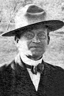
Emil Bibo
1860 - 1916
Simon Bibo was one of the most influential merchants and community leaders in early New Mexico, part of a pioneering family whose commercial and political reach extended across the entire state. By the time he became involved in the Grants region, Bibo had already established himself as a respected trader, landholder, and civic figure with deep ties to Laguna, Acoma, and the surrounding pueblos. His presence in the early commercial development of Grants reflects the broader impact of the Bibo family on New Mexico’s territorial and early‑statehood economy. Early Life & Immigration Simon Bibo was born in 1845 in Prussia (modern‑day Germany), part of a Jewish family that would become one of the most influential mercantile dynasties in New Mexico. Simon and his brothers — including Solomon, Nathan, and Louis — immigrated to the United States in the mid‑19th century during a period of widespread European migration. Drawn by opportunity and the expanding frontier economy, the Bibo brothers made their way west, eventually settling in the New Mexico Territory. Arrival in New Mexico & Early Mercantile Work By the 1860s and 1870s, the Bibo brothers had established trading posts throughout the region, including at Laguna Pueblo, Acoma Pueblo, and other key points along early transportation routes. Their operations were known for fairness, reliability, and strong relationships with Native communities — a rarity in the era. Simon, like his brothers, became fluent in local languages and customs, earning trust and building long‑term partnerships. Role in Laguna, Acoma, and Regional Trade The Bibo family became deeply integrated into the cultural and economic life of the pueblos. Their trading posts supplied: food tools cloth livestock building materials credit and financial services Simon’s work helped establish a stable commercial network that connected remote communities to the broader territorial economy. Expansion Toward Grants & the Railroad Era When the Atlantic & Pacific Railroad pushed through the region in the 1880s, the Bibo family expanded their operations westward. Simon became involved in land transactions, supply contracts, and commercial development tied to the new rail corridor. By the early 1900s, as Grants began to form around the railroad siding, Simon’s influence extended into: land leasing supply chains early commercial partnerships support for new businesses His presence helped shape the economic foundation of the emerging town. Ties to Early Grants Businesses Although Simon did not own the Yucca or Lux, his mercantile network supplied many early businesses in the region. His connections linked him to: early hotel operators ranching families railroad crews construction contractors territorial‑era merchants The Bibo family’s reach meant that nearly every early business in Grants had some connection — direct or indirect — to their trade network. Political & Civic Influence The Bibo family held numerous civic roles across New Mexico, including: postmasters mayors county officials community negotiators advocates for Native communities Simon himself was known for diplomacy, fairness, and long‑standing relationships with tribal leaders. Later Life & Legacy Simon Bibo died in 1922, leaving behind a legacy that stretched far beyond any single town. His family’s mercantile empire shaped the economic development of western New Mexico for decades, and their influence is still recognized in historical records, community memory, and regional heritage. In Grants, Simon’s legacy is tied to the earliest commercial foundations of the town — a reminder that the community was shaped not only by local builders and business owners, but by regional figures whose work connected the area to the wider world.
1921
Grant — Uranium Capital of the World
Grants Cut and Mt. Taylor
Locomotive 2926 heading west through
Grants Cut
BERNALILLO MERCANTILE CO.
1914 - 1921
Owner: Carl Seligman
Manager:
Phone: None
POST OFFICE (1st Post Office)
1881 - 1930s
Postmaster: Charles Neustadt
Notary Public
1881 - 1930s
Justice of the Peace: Carl Seligman
Western Union Express, Wells Fargo & Co.
1881 - 1930s
Agent: William Webb
Stage Coaches
1903 - 1930s
Stage to San Mateo: Jesus Blea
Stage to Cooperton: Narcisco Vallejos
1927 — Yucca Hotel Expands Services
By 1927, the Yucca Hotel had become one of Grants’ most reliable lodging houses, offering meals, rooms, and traveler accommodations during the early years of Route 66. Local directory listings from this period show the hotel advertising steady service and dependable management, reflecting its growing role as a community anchor before the major highway boom of the 1930s.
1921 — Business Listing for
Bernalillo Mercantile Co.
Grant, New Mexico Territory
Source: Courtesy of Patricia McClure
August 6, 1914
1969 -- Grants High School "Pirates Ahoy"
Sponsor ad for Cibola Motor Inc.
Grants, New Mexico
Artifact: Archival photographs of the 1941 Fourth of July Parade
Source: Cibola County History Museum
Retrieved from: Public post by the Cibola County History Museum on Facebook
Caption: Scenes from the 1941 Fourth of July Parade showing downtown Grants, including the Yucca Café, Cabot Drugs, and early Route 66 streetscape.
A 1927 directory entry highlights the Yucca Hotel’s early reputation for consistent service and traveler accommodations.
1929
Grant — Uranium Capital of the World
Grants Cut and Mt. Taylor
Locomotive 2926 heading west through
Grants Cut
BERNALILLO MERCANTILE CO.
1921 - 1945
Owner: Carl Seligman
Manager: H. L. Weise
Phone: None
POST OFFICE (1st Post Office)
1881 - 1930s
Postmaster: Charles Neustadt
Notary Public & Justice of the Peace
1881 - 1930s
Justice of the Peace: Joseph Sanchez
Notary Public: Charles Neustadt
Western Union Tel Co.
1881 - 1930s
Chief Operator: B. J. Dannenbaum
1927 — Yucca Hotel Expands Services
By 1927, the Yucca Hotel had become one of Grants’ most reliable lodging houses, offering meals, rooms, and traveler accommodations during the early years of Route 66. Local directory listings from this period show the hotel advertising steady service and dependable management, reflecting its growing role as a community anchor before the major highway boom of the 1930s.
1926 — Business Listing for
Bernalillo Mercantile Co.
Grant, New Mexico Territory
Source: Courtesy of Patricia McClure
August 6, 1914
1969 -- Grants High School "Pirates Ahoy"
Sponsor ad for Cibola Motor Inc.
Grants, New Mexico
Artifact: Archival photographs of the 1941 Fourth of July Parade
Source: Cibola County History Museum
Retrieved from: Public post by the Cibola County History Museum on Facebook
Caption: Scenes from the 1941 Fourth of July Parade showing downtown Grants, including the Yucca Café, Cabot Drugs, and early Route 66 streetscape.
A 1927 directory entry highlights the Yucca Hotel’s early reputation for consistent service and traveler accommodations.
1945
Grant — Uranium Capital of the World
Grants Cut and Mt. Taylor
Locomotive 2926 heading west through
Grants Cut
VALLEY MERCANTILE CO.
1945 - 1953
Owner: Carrol Gunderson (Bond-Gunderson Co.)
Grocery Department Manager: John Schadel
Phone: None
1945 — Business Listing for
Valley Mercantile Co.
Grants, New Mexico Territory
Source: Courtesy of Patricia McClure
1927 — Yucca Hotel Expands Services
By 1927, the Yucca Hotel had become one of Grants’ most reliable lodging houses, offering meals, rooms, and traveler accommodations during the early years of Route 66. Local directory listings from this period show the hotel advertising steady service and dependable management, reflecting its growing role as a community anchor before the major highway boom of the 1930s.
August 6, 1914
1969 -- Grants High School "Pirates Ahoy"
Sponsor ad for Cibola Motor Inc.
Grants, New Mexico
Artifact: Archival photographs of the 1941 Fourth of July Parade
Source: Cibola County History Museum
Retrieved from: Public post by the Cibola County History Museum on Facebook
Caption: Scenes from the 1941 Fourth of July Parade showing downtown Grants, including the Yucca Café, Cabot Drugs, and early Route 66 streetscape.
A 1927 directory entry highlights the Yucca Hotel’s early reputation for consistent service and traveler accommodations.
1952
Grant — Uranium Capital of the World
Grants Cut and Mt. Taylor
Locomotive 2926 heading west through
Grants Cut
VALLEY MERCANTILE CO.
1945 - 1953
Owner: Carrol Gunderson (Bond-Gunderson Co.)
Grocery Department Manager: John Schadel
Phone: None
1927 — Yucca Hotel Expands Services
By 1927, the Yucca Hotel had become one of Grants’ most reliable lodging houses, offering meals, rooms, and traveler accommodations during the early years of Route 66. Local directory listings from this period show the hotel advertising steady service and dependable management, reflecting its growing role as a community anchor before the major highway boom of the 1930s.
A 1927 directory entry highlights the Yucca Hotel’s early reputation for consistent service and traveler accommodations.
1952 — Business Listing for
Valley Mercantile Co.
Grants, New Mexico Territory
Source: Courtesy of Patricia McClure
August 6, 1914
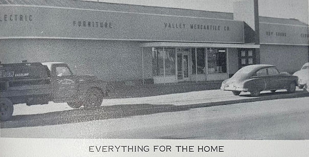
1969 -- Grants High School "Pirates Ahoy"
Sponsor ad for Cibola Motor Inc.
Grants, New Mexico
Artifact: Archival photographs of the 1941 Fourth of July Parade
Source: Cibola County History Museum
Retrieved from: Public post by the Cibola County History Museum on Facebook
Caption: Scenes from the 1941 Fourth of July Parade showing downtown Grants, including the Yucca Café, Cabot Drugs, and early Route 66 streetscape.
1953
Grant — Uranium Capital of the World
Grants Cut and Mt. Taylor
Locomotive 2926 heading west through
Grants Cut
GLADDIN'S SUPER MARKET
1953 - 1957
Owner: Carrol Gunderson (Bond-Gunderson Co.)
Grocery Department Manager: John Schadel
Phone: None
1927 — Yucca Hotel Expands Services
By 1927, the Yucca Hotel had become one of Grants’ most reliable lodging houses, offering meals, rooms, and traveler accommodations during the early years of Route 66. Local directory listings from this period show the hotel advertising steady service and dependable management, reflecting its growing role as a community anchor before the major highway boom of the 1930s.
A 1927 directory entry highlights the Yucca Hotel’s early reputation for consistent service and traveler accommodations.
1953 — Article for
Gladdin's Super Market
Grants, New Mexico
Source: Courtesy of Patricia McClure
The Gallup Independent
May 21, 1953
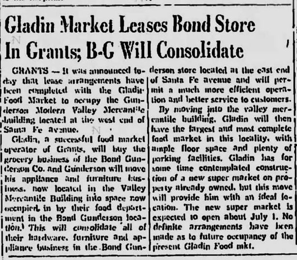
1969 -- Grants High School "Pirates Ahoy"
Sponsor ad for Cibola Motor Inc.
Grants, New Mexico
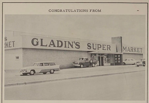
1969 -- Grants High School "Pirates Ahoy"
Sponsor ad for Cibola Motor Inc.
Grants, New Mexico
Artifact: Archival photographs of the 1941 Fourth of July Parade
Source: Cibola County History Museum
Retrieved from: Public post by the Cibola County History Museum on Facebook
Caption: Scenes from the 1941 Fourth of July Parade showing downtown Grants, including the Yucca Café, Cabot Drugs, and early Route 66 streetscape.
1957
Grant — Uranium Capital of the World
Grants Cut and Mt. Taylor
Locomotive 2926 heading west through
Grants Cut
STURGES SUPER MARKET
1957 - 1953
Owner: Fritz Sturges
Grocery Department Manager: John Schadel
Phone: None
1927 — Yucca Hotel Expands Services
By 1927, the Yucca Hotel had become one of Grants’ most reliable lodging houses, offering meals, rooms, and traveler accommodations during the early years of Route 66. Local directory listings from this period show the hotel advertising steady service and dependable management, reflecting its growing role as a community anchor before the major highway boom of the 1930s.
A 1927 directory entry highlights the Yucca Hotel’s early reputation for consistent service and traveler accommodations.
1957 — Business Listing for
Sturges Super Market
Grants, New Mexico
Source: Courtesy of Patricia McClure
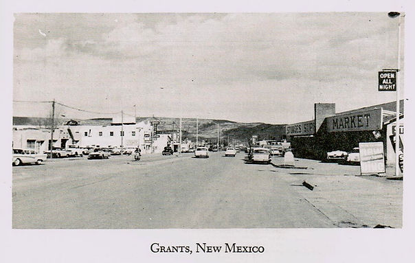
1969 -- Grants High School "Pirates Ahoy"
Sponsor ad for Cibola Motor Inc.
Grants, New Mexico
The Gallup Independent
May 21, 1953
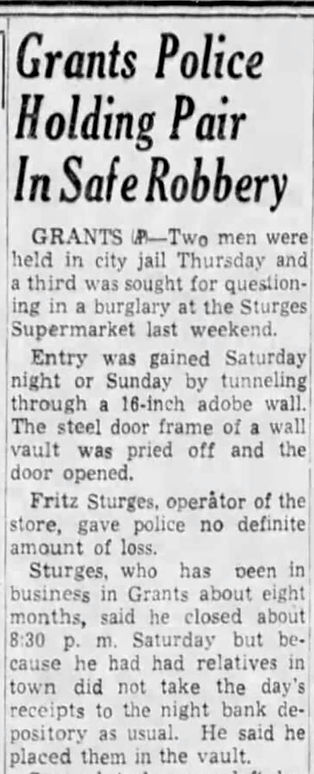

1969 -- Grants High School "Pirates Ahoy"
Sponsor ad for Cibola Motor Inc.
Grants, New Mexico
Artifact: Archival photographs of the 1941 Fourth of July Parade
Source: Cibola County History Museum
Retrieved from: Public post by the Cibola County History Museum on Facebook
Caption: Scenes from the 1941 Fourth of July Parade showing downtown Grants, including the Yucca Café, Cabot Drugs, and early Route 66 streetscape.
1963
Grant — Uranium Capital of the World
Grants Cut and Mt. Taylor
Locomotive 2926 heading west through
Grants Cut
GRANTS SURPLUS CITY
1963 - 1977
Owner: Fritz Sturges
Grocery Department Manager: John Schadel
Phone: AT 7-4856
1927 — Yucca Hotel Expands Services
By 1927, the Yucca Hotel had become one of Grants’ most reliable lodging houses, offering meals, rooms, and traveler accommodations during the early years of Route 66. Local directory listings from this period show the hotel advertising steady service and dependable management, reflecting its growing role as a community anchor before the major highway boom of the 1930s.
1963 — Business Listing for
Sturges Super Market
Grants, New Mexico
Source: Courtesy of Patricia McClure
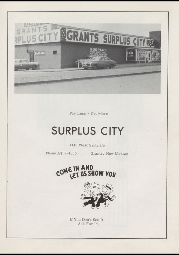
1969 -- Grants High School "Pirates Ahoy"
Sponsor ad for Cibola Motor Inc.
Grants, New Mexico
Artifact: Archival photographs of the 1941 Fourth of July Parade
Source: Cibola County History Museum
Retrieved from: Public post by the Cibola County History Museum on Facebook
Caption: Scenes from the 1941 Fourth of July Parade showing downtown Grants, including the Yucca Café, Cabot Drugs, and early Route 66 streetscape.
A 1927 directory entry highlights the Yucca Hotel’s early reputation for consistent service and traveler accommodations.
1964
Grant — Uranium Capital of the World
Grants Cut and Mt. Taylor
Locomotive 2926 heading west through
Grants Cut
GRANTS SURPLUS CITY
1963 - 1976
Owner: Fritz Sturges
Grocery Department Manager: John Schadel
Phone: None
1927 — Yucca Hotel Expands Services
By 1927, the Yucca Hotel had become one of Grants’ most reliable lodging houses, offering meals, rooms, and traveler accommodations during the early years of Route 66. Local directory listings from this period show the hotel advertising steady service and dependable management, reflecting its growing role as a community anchor before the major highway boom of the 1930s.
1964 — Business Listing for
Sturges Super Market
Grants, New Mexico
Source: Courtesy of Patricia McClure
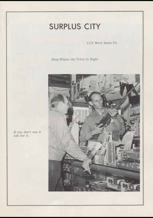
1969 -- Grants High School "Pirates Ahoy"
Sponsor ad for Cibola Motor Inc.
Grants, New Mexico
Artifact: Archival photographs of the 1941 Fourth of July Parade
Source: Cibola County History Museum
Retrieved from: Public post by the Cibola County History Museum on Facebook
Caption: Scenes from the 1941 Fourth of July Parade showing downtown Grants, including the Yucca Café, Cabot Drugs, and early Route 66 streetscape.
A 1927 directory entry highlights the Yucca Hotel’s early reputation for consistent service and traveler accommodations.
1910
1978
Grant — Uranium Capital of the World
Grants Cut and Mt. Taylor
Locomotive 2926 heading west through
Grants Cut
FALCOMATA MOTORS
1978 - 2020
1977 — Business Listing for
Sturges Super Market
Grants, New Mexico
Source: Courtesy of Patricia McClure
Owner: Fritz Sturges
Grocery Department Manager: John Schadel
Phone: 287-9265
1927 — Yucca Hotel Expands Services
By 1927, the Yucca Hotel had become one of Grants’ most reliable lodging houses, offering meals, rooms, and traveler accommodations during the early years of Route 66. Local directory listings from this period show the hotel advertising steady service and dependable management, reflecting its growing role as a community anchor before the major highway boom of the 1930s.
1969 -- Grants High School "Pirates Ahoy"
Sponsor ad for Cibola Motor Inc.
Grants, New Mexico
Artifact: Archival photographs of the 1941 Fourth of July Parade
Source: Cibola County History Museum
Retrieved from: Public post by the Cibola County History Museum on Facebook
Caption: Scenes from the 1941 Fourth of July Parade showing downtown Grants, including the Yucca Café, Cabot Drugs, and early Route 66 streetscape.
A 1927 directory entry highlights the Yucca Hotel’s early reputation for consistent service and traveler accommodations.
1977

Valencia County
Grant's Camp — New Mexico Territory

C and C AUTO SALES
1976 - 1978
1977 — Business Listing for
Sturges Super Market
Grants, New Mexico
Source: Courtesy of Patricia McClure
1116 W. Santa Fe Avenue
Downtown Grants
Ades Liquors Parcel
The building at 110 W. Santa Fe Avenue was constructed in the late 1960s on the west end of the former Tropical Lounge/California Bar parcel. This subdivision occurred before the bar was demolished, and the new structure appears in late‑1960s photographs of the California Bar.
The first documented tenant was Pacific Finance, which relocated here by 1973 after previously operating at 807 W. Santa Fe Avenue in 1966, 1967, and 1968. Over the next five decades, the building housed a sequence of small professional, retail, and service businesses that reflect the changing needs of Grants residents as Santa Fe Avenue transitioned from a Route 66 travel corridor into a locally focused business district.
1912-1926
1912-1926
1926-1948
1948-1961
1961-1971
1971-1985
1912-1927
1927-Present
1972-Present
1985-Present
1985-Present
1985-Present
1985-Present
1985-Present
1991-Present
1998-Present
1998-Present
2010-Present
The development of 110 W. Santa Fe reflects the final wave of mid‑century infill along the 100 block, providing new commercial space as Grants expanded and diversified.
1968
Grant — Uranium Capital of the World
Grants Cut and Mt. Taylor
Locomotive 2926 heading west through
Grants Cut
Founders & Builders (1909-1910)
Simon Bibo
1845 - 1922
Simon Bibo was one of the most influential merchants and community leaders in early New Mexico, part of a pioneering family whose commercial and political reach extended across the entire state. By the time he became involved in the Grants region, Bibo had already established himself as a respected trader, landholder, and civic figure with deep ties to Laguna, Acoma, and the surrounding pueblos. His presence in the early commercial development of Grants reflects the broader impact of the Bibo family on New Mexico’s territorial and early‑statehood economy. Early Life & Immigration Simon Bibo was born in 1845 in Prussia (modern‑day Germany), part of a Jewish family that would become one of the most influential mercantile dynasties in New Mexico. Simon and his brothers — including Solomon, Nathan, and Louis — immigrated to the United States in the mid‑19th century during a period of widespread European migration. Drawn by opportunity and the expanding frontier economy, the Bibo brothers made their way west, eventually settling in the New Mexico Territory. Arrival in New Mexico & Early Mercantile Work By the 1860s and 1870s, the Bibo brothers had established trading posts throughout the region, including at Laguna Pueblo, Acoma Pueblo, and other key points along early transportation routes. Their operations were known for fairness, reliability, and strong relationships with Native communities — a rarity in the era. Simon, like his brothers, became fluent in local languages and customs, earning trust and building long‑term partnerships. Role in Laguna, Acoma, and Regional Trade The Bibo family became deeply integrated into the cultural and economic life of the pueblos. Their trading posts supplied: food tools cloth livestock building materials credit and financial services Simon’s work helped establish a stable commercial network that connected remote communities to the broader territorial economy. Expansion Toward Grants & the Railroad Era When the Atlantic & Pacific Railroad pushed through the region in the 1880s, the Bibo family expanded their operations westward. Simon became involved in land transactions, supply contracts, and commercial development tied to the new rail corridor. By the early 1900s, as Grants began to form around the railroad siding, Simon’s influence extended into: land leasing supply chains early commercial partnerships support for new businesses His presence helped shape the economic foundation of the emerging town. Ties to Early Grants Businesses Although Simon did not own the Yucca or Lux, his mercantile network supplied many early businesses in the region. His connections linked him to: early hotel operators ranching families railroad crews construction contractors territorial‑era merchants The Bibo family’s reach meant that nearly every early business in Grants had some connection — direct or indirect — to their trade network. Political & Civic Influence The Bibo family held numerous civic roles across New Mexico, including: postmasters mayors county officials community negotiators advocates for Native communities Simon himself was known for diplomacy, fairness, and long‑standing relationships with tribal leaders. Later Life & Legacy Simon Bibo died in 1922, leaving behind a legacy that stretched far beyond any single town. His family’s mercantile empire shaped the economic development of western New Mexico for decades, and their influence is still recognized in historical records, community memory, and regional heritage. In Grants, Simon’s legacy is tied to the earliest commercial foundations of the town — a reminder that the community was shaped not only by local builders and business owners, but by regional figures whose work connected the area to the wider world.
Joesph "Joe" Cappelli
1880 - 1973
Joseph “Joe” Cappelli was an Italian‑born stonemason and contractor who helped shape early Grants during its first major boom. Best known for building the Yucca Hotel for George Ade on the former site of Latham’s Stockman’s Store, Cappelli lived only a few blocks from downtown and worked during the years when Grants transformed from a railroad siding into a true town. His craftsmanship produced one of the earliest and most important commercial buildings in Grants — a structure that later became a featured landmark on early Route 66 and the Will Rogers Highway. Early Life & Immigration Simon Bibo was born in 1845 in Prussia (modern‑day Germany), part of a Jewish family that would become one of the most influential mercantile dynasties in New Mexico. Simon and his brothers — including Solomon, Nathan, and Louis — immigrated to the United States in the mid‑19th century during a period of widespread European migration. Drawn by opportunity and the expanding frontier economy, the Bibo brothers made their way west, eventually settling in the New Mexico Territory. Arrival in New Mexico & Early Mercantile Work By the 1860s and 1870s, the Bibo brothers had established trading posts throughout the region, including at Laguna Pueblo, Acoma Pueblo, and other key points along early transportation routes. Their operations were known for fairness, reliability, and strong relationships with Native communities — a rarity in the era. Simon, like his brothers, became fluent in local languages and customs, earning trust and building long‑term partnerships. Role in Laguna, Acoma, and Regional Trade The Bibo family became deeply integrated into the cultural and economic life of the pueblos. Their trading posts supplied: food tools cloth livestock building materials credit and financial services Simon’s work helped establish a stable commercial network that connected remote communities to the broader territorial economy. Expansion Toward Grants & the Railroad Era When the Atlantic & Pacific Railroad pushed through the region in the 1880s, the Bibo family expanded their operations westward. Simon became involved in land transactions, supply contracts, and commercial development tied to the new rail corridor. By the early 1900s, as Grants began to form around the railroad siding, Simon’s influence extended into: land leasing supply chains early commercial partnerships support for new businesses His presence helped shape the economic foundation of the emerging town. Ties to Early Grants Businesses Although Simon did not own the Yucca or Lux, his mercantile network supplied many early businesses in the region. His connections linked him to: early hotel operators ranching families railroad crews construction contractors territorial‑era merchants The Bibo family’s reach meant that nearly every early business in Grants had some connection — direct or indirect — to their trade network. Political & Civic Influence The Bibo family held numerous civic roles across New Mexico, including: postmasters mayors county officials community negotiators advocates for Native communities Simon himself was known for diplomacy, fairness, and long‑standing relationships with tribal leaders. Later Life & Legacy Simon Bibo died in 1922, leaving behind a legacy that stretched far beyond any single town. His family’s mercantile empire shaped the economic development of western New Mexico for decades, and their influence is still recognized in historical records, community memory, and regional heritage. In Grants, Simon’s legacy is tied to the earliest commercial foundations of the town — a reminder that the community was shaped not only by local builders and business owners, but by regional figures whose work connected the area to the wider world.
1120 W. Santa Fe Avenue
Downtown Grants
Ades Liquors Parcel
The building at 110 W. Santa Fe Avenue was constructed in the late 1960s on the west end of the former Tropical Lounge/California Bar parcel. This subdivision occurred before the bar was demolished, and the new structure appears in late‑1960s photographs of the California Bar.
The first documented tenant was Pacific Finance, which relocated here by 1973 after previously operating at 807 W. Santa Fe Avenue in 1966, 1967, and 1968. Over the next five decades, the building housed a sequence of small professional, retail, and service businesses that reflect the changing needs of Grants residents as Santa Fe Avenue transitioned from a Route 66 travel corridor into a locally focused business district.
The development of 110 W. Santa Fe reflects the final wave of mid‑century infill along the 100 block, providing new commercial space as Grants expanded and diversified.
1968
Valencia County
Grants — New Mexico